Nokia N-GAGE User Guide - Page 77
Traffic and safety, Stop navigating
 |
UPC - 758478517055
View all Nokia N-GAGE manuals
Add to My Manuals
Save this manual to your list of manuals |
Page 77 highlights
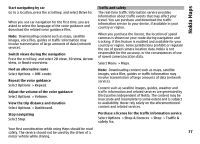
Nokia Maps Start navigating by car Go to a location, press the scroll key, and select Drive to. When you use car navigation for the first time, you are asked to select the language of the voice guidance and download the related voice guidance files. Note: Downloading content such as maps, satellite images, voice files, guides or traffic information may involve transmission of large amounts of data (network service). Switch views during the navigation Press the scroll key, and select 2D view, 3D view, Arrow view, or Route overview. Find an alternative route Select Options > Diff. route. Repeat the voice guidance Select Options > Repeat. Adjust the volume of the voice guidance Select Options > Volume. View the trip distance and duration Select Options > Dashboard. Stop navigating Select Stop. Traffic and safety The real-time traffic information service provides information about traffic events that may affect your travel. You can purchase and download the traffic information service to your device, if available in your country or region. When you purchase the licence, the location of speed cameras is shown on your route during navigation and tracking, if this feature is enabled and available for your country or region. Some jurisdictions prohibit or regulate the use of speed camera location data. Nokia is not responsible for the accuracy, or the consequences of use of speed camera location data. Select Menu > Maps. Note: Downloading content such as maps, satellite images, voice files, guides or traffic information may involve transmission of large amounts of data (network service). Content such as satellite images, guides, weather and traffic information and related services are generated by third parties independent of Nokia. The content may be inaccurate and incomplete to some extent and is subject to availability. Never rely solely on the aforementioned content and related services. Purchase a licence for the traffic information service Select Options > Shop & licences > Shop > Traffic & safety %s. Your first consideration while using Maps should be road safety. The service should not be used by the driver of a 77 motor vehicle while driving.
-
 1
1 -
2
-
3
-
4
-
5
-
6
-
7
-
8
-
9
-
10
-
11
-
12
-
13
-
14
-
15
-
16
-
17
-
18
-
19
-
20
-
21
-
22
-
23
-
24
-
25
-
26
-
27
-
28
-
29
-
30
-
31
-
32
-
33
-
34
-
35
-
36
-
37
-
38
-
39
-
40
-
41
-
42
-
43
-
44
-
45
-
46
-
47
-
48
-
49
-
50
-
51
-
52
-
53
-
54
-
55
-
56
-
57
-
58
-
59
-
60
-
61
-
62
-
63
-
64
-
65
-
66
-
67
-
68
-
69
-
70
-
71
-
 72
72 -
 73
73 -
 74
74 -
 75
75 -
 76
76 -
 77
77 -
 78
78 -
 79
79 -
 80
80 -
 81
81 -
 82
82 -
83
-
84
-
85
-
86
-
87
-
88
-
89
-
90
-
91
-
92
-
93
-
94
-
95
-
96
-
97
-
98
-
99
-
100
-
101
-
102
-
103
-
104
-
105
-
106
-
107
-
108
-
109
-
110
-
111
-
112
-
113
-
114
-
115
-
116
-
117
-
118
-
119
-
120
-
121
-
122
-
123
-
124
-
125
-
126
-
127
-
128
-
129
-
130
-
131
-
132
-
133
-
134
-
135
-
136
-
137
-
138
-
139
-
140
-
141
-
142
-
143
-
144
-
145
-
146
-
147
-
148
-
149
-
150
-
151
-
152
-
153
-
154
-
155
-
156
-
157
-
158
-
159
 |
 |
