2014 Nissan Pathfinder Navigation System Owner's Manual - Page 145
2014 Nissan Pathfinder Manual

Page 145 highlights
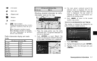
VIEWING INFORMATION ABOUT CURRENT VEHICLE LOCATION This displays the information about the vehicle location on the route when driving according to route guidance. 4 * 5 * VIEWING AVAILABLE TRAFFIC INFORMATION Displays the distance to the next intersection on the route. Displays the distance traveled from the previous intersection on the route. NavTraffic information is a subscription service offered by SiriusXM Satellite Radio. This service provides real-time information regarding traffic flow, accidents, road construction and other incidents, where available. NavTraffic combines information from commercial and public traffic data providers including government departments of transportation, police, emergency services, road sensors, cameras and aircraft reports. The traffic information is broadcast to the vehicle by the SiriusXM satellites. Available traffic information on the route the driver selected is shown on the navigation screen so traffic conditions between you and the destination are known. Three types of real-time traffic information for major roadways are shown on the navigation system: * Unscheduled traffic data for example, accidents and disabled vehicles. * Scheduled traffic data, for example road construction and road closures. * Traffic flow information (rate of speed data). BASIC OPERATION 1. Push . 2. Highlight [Where am I?] and push . 3. Push to return to the previous screen. Push to return to the current location map screen. Contents of vehicle location information 1 * 2 * 3 * Next Street: Displays the next street on the route. Current Street: Displays the current street on the route. Previous Street: Displays the previous street on the route. WARNING NavTraffic information is not a substitute for attentive driving. Traffic conditions change constantly and emergency Viewing technical information 7-3
-
 1
1 -
2
-
3
-
4
-
5
-
6
-
7
-
8
-
9
-
10
-
11
-
12
-
13
-
14
-
15
-
16
-
17
-
18
-
19
-
20
-
21
-
22
-
23
-
24
-
25
-
26
-
27
-
28
-
29
-
30
-
31
-
32
-
33
-
34
-
35
-
36
-
37
-
38
-
39
-
40
-
41
-
42
-
43
-
44
-
45
-
46
-
47
-
48
-
49
-
50
-
51
-
52
-
53
-
54
-
55
-
56
-
57
-
58
-
59
-
60
-
61
-
62
-
63
-
64
-
65
-
66
-
67
-
68
-
69
-
70
-
71
-
72
-
73
-
74
-
75
-
76
-
77
-
78
-
79
-
80
-
81
-
82
-
83
-
84
-
85
-
86
-
87
-
88
-
89
-
90
-
91
-
92
-
93
-
94
-
95
-
96
-
97
-
98
-
99
-
100
-
101
-
102
-
103
-
104
-
105
-
106
-
107
-
108
-
109
-
110
-
111
-
112
-
113
-
114
-
115
-
116
-
117
-
118
-
119
-
120
-
121
-
122
-
123
-
124
-
125
-
126
-
127
-
128
-
129
-
130
-
131
-
132
-
133
-
134
-
135
-
136
-
137
-
138
-
139
-
 140
140 -
 141
141 -
 142
142 -
 143
143 -
 144
144 -
 145
145 -
 146
146 -
 147
147 -
 148
148 -
 149
149 -
 150
150 -
151
-
152
-
153
-
154
-
155
-
156
-
157
-
158
-
159
-
160
-
161
-
162
-
163
-
164
-
165
-
166
-
167
-
168
-
169
-
170
-
171
-
172
-
173
-
174
-
175
-
176
-
177
-
178
-
179
-
180
-
181
-
182
-
183
-
184
-
185
-
186
-
187
-
188
-
189
-
190
-
191
-
192
-
193
-
194
-
195
-
196
-
197
-
198
-
199
-
200
-
201
-
202
-
203
-
204
-
205
-
206
-
207
-
208
-
209
-
210
-
211
-
212
-
213
-
214
-
215
-
216
-
217
-
218
-
219
-
220
-
221
-
222
-
223
-
224
-
225
-
226
-
227
-
228
-
229
-
230
-
231
-
232
-
233
-
234
-
235
-
236
-
237
-
238
-
239
-
240
-
241
-
242
-
243
-
244
-
245
-
246
-
247
-
248
-
249
-
250
-
251
-
252
 |
 |
