2014 Nissan Pathfinder Navigation System Owner's Manual - Page 47
2014 Nissan Pathfinder Manual

Page 47 highlights
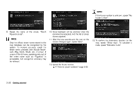
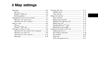
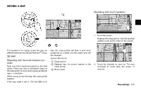
7 * 8 * 9 * 10 * 11 * Arrow: Indicates the distance to the next guide point and the turning direction at that guide point. Stored location (orange): Displays the locations that are stored in the Address Book. Icons can be changed according to personal preferences. "Storing location" (page 6-2) Avoid Area (green or blue): Displays the areas to avoid that are stored in the Address Book with green or blue icons. During the route search, the route guidance is performed by searching for a route that avoids those areas. "Storing avoid area" (page 6-7) Street name: Displays the name of the street the vehicle is currently driving on. Traffic indicator: Displays the reception condition of traffic information transmitted from the provider. Green: Reception condition is good. Gray: Reception condition is not good. No mark: Subscription to NavTraffic service is not detected. BirdviewTM (3D) MAP BirdviewTM displays the map from an elevated perspective. In BirdviewTM, it is easy to recognize an image of the route because it provides a panoramic view over a long distance. The method to look at the map is the same for the 2D and BirdviewTM maps. Building footprint graphics (2D map) INFO: About the BirdviewTM display . "BirdviewTM" is a registered trademark of Clarion Co., Ltd. . The map in BirdviewTM always appears with the current forward direction facing up. 3D building graphics (BirdviewTM map) INFO: In the area where the building graphics are not stored in the map data, the normal map is displayed even when the map is zoomed in. BUILDING GRAPHICS In the area where the building graphics are stored in the map data, the building graphics are displayed when the map is zoomed in. On the 2D map display, these are called "Building footprint graphics", and on the Birdview TM display, these are called "3D building graphics". Map settings 3-3
-
 1
1 -
2
-
3
-
4
-
5
-
6
-
7
-
8
-
9
-
10
-
11
-
12
-
13
-
14
-
15
-
16
-
17
-
18
-
19
-
20
-
21
-
22
-
23
-
24
-
25
-
26
-
27
-
28
-
29
-
30
-
31
-
32
-
33
-
34
-
35
-
36
-
37
-
38
-
39
-
40
-
41
-
 42
42 -
 43
43 -
 44
44 -
 45
45 -
 46
46 -
 47
47 -
 48
48 -
 49
49 -
 50
50 -
 51
51 -
 52
52 -
53
-
54
-
55
-
56
-
57
-
58
-
59
-
60
-
61
-
62
-
63
-
64
-
65
-
66
-
67
-
68
-
69
-
70
-
71
-
72
-
73
-
74
-
75
-
76
-
77
-
78
-
79
-
80
-
81
-
82
-
83
-
84
-
85
-
86
-
87
-
88
-
89
-
90
-
91
-
92
-
93
-
94
-
95
-
96
-
97
-
98
-
99
-
100
-
101
-
102
-
103
-
104
-
105
-
106
-
107
-
108
-
109
-
110
-
111
-
112
-
113
-
114
-
115
-
116
-
117
-
118
-
119
-
120
-
121
-
122
-
123
-
124
-
125
-
126
-
127
-
128
-
129
-
130
-
131
-
132
-
133
-
134
-
135
-
136
-
137
-
138
-
139
-
140
-
141
-
142
-
143
-
144
-
145
-
146
-
147
-
148
-
149
-
150
-
151
-
152
-
153
-
154
-
155
-
156
-
157
-
158
-
159
-
160
-
161
-
162
-
163
-
164
-
165
-
166
-
167
-
168
-
169
-
170
-
171
-
172
-
173
-
174
-
175
-
176
-
177
-
178
-
179
-
180
-
181
-
182
-
183
-
184
-
185
-
186
-
187
-
188
-
189
-
190
-
191
-
192
-
193
-
194
-
195
-
196
-
197
-
198
-
199
-
200
-
201
-
202
-
203
-
204
-
205
-
206
-
207
-
208
-
209
-
210
-
211
-
212
-
213
-
214
-
215
-
216
-
217
-
218
-
219
-
220
-
221
-
222
-
223
-
224
-
225
-
226
-
227
-
228
-
229
-
230
-
231
-
232
-
233
-
234
-
235
-
236
-
237
-
238
-
239
-
240
-
241
-
242
-
243
-
244
-
245
-
246
-
247
-
248
-
249
-
250
-
251
-
252
 |
 |