2014 Nissan Pathfinder Navigation System Owner's Manual - Page 46
2014 Nissan Pathfinder Manual

Page 46 highlights
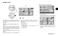
MAP TYPES Two types of map views are available: 2D and BirdviewTM (3D) map. This indicator will appear when the destination or waypoint is set and route guidance is started. When the vehicle is not driven on the suggested route, the screen displays the direction to the destination and the distance to the destination from the current vehicle position. "Switching estimated arrival time display" (page 5-28) Suggested route: Appears in bold yellow during route guidance. / Direction indicator: Indicates the directional setting of the map. Touch the icon to change the setting. : North always pointing up. : Traveling direction always pointing up. "Setting map orientation" (page 3-14) Scale indicator: Indicates the scale of the map. Touch the icon to display the scale bar. This allows the map scale to be adjusted. "Operating with touch operation" (page 3-10) 2D MAP 2D map displays the map in a 2-dimensional environment similar to a road map. Screen information 4 * 5 * 6 * 1 * Vehicle icon: Indicates the current vehicle location and the direction of travel. 2 * 3 * Guide point: Indicates a guide point on the route. Remaining time and distance to the destination: Indicates the approximate remaining time and distance to the destination or waypoint. 3-2 Map settings
-
 1
1 -
2
-
3
-
4
-
5
-
6
-
7
-
8
-
9
-
10
-
11
-
12
-
13
-
14
-
15
-
16
-
17
-
18
-
19
-
20
-
21
-
22
-
23
-
24
-
25
-
26
-
27
-
28
-
29
-
30
-
31
-
32
-
33
-
34
-
35
-
36
-
37
-
38
-
39
-
40
-
 41
41 -
 42
42 -
 43
43 -
 44
44 -
 45
45 -
 46
46 -
 47
47 -
 48
48 -
 49
49 -
 50
50 -
 51
51 -
52
-
53
-
54
-
55
-
56
-
57
-
58
-
59
-
60
-
61
-
62
-
63
-
64
-
65
-
66
-
67
-
68
-
69
-
70
-
71
-
72
-
73
-
74
-
75
-
76
-
77
-
78
-
79
-
80
-
81
-
82
-
83
-
84
-
85
-
86
-
87
-
88
-
89
-
90
-
91
-
92
-
93
-
94
-
95
-
96
-
97
-
98
-
99
-
100
-
101
-
102
-
103
-
104
-
105
-
106
-
107
-
108
-
109
-
110
-
111
-
112
-
113
-
114
-
115
-
116
-
117
-
118
-
119
-
120
-
121
-
122
-
123
-
124
-
125
-
126
-
127
-
128
-
129
-
130
-
131
-
132
-
133
-
134
-
135
-
136
-
137
-
138
-
139
-
140
-
141
-
142
-
143
-
144
-
145
-
146
-
147
-
148
-
149
-
150
-
151
-
152
-
153
-
154
-
155
-
156
-
157
-
158
-
159
-
160
-
161
-
162
-
163
-
164
-
165
-
166
-
167
-
168
-
169
-
170
-
171
-
172
-
173
-
174
-
175
-
176
-
177
-
178
-
179
-
180
-
181
-
182
-
183
-
184
-
185
-
186
-
187
-
188
-
189
-
190
-
191
-
192
-
193
-
194
-
195
-
196
-
197
-
198
-
199
-
200
-
201
-
202
-
203
-
204
-
205
-
206
-
207
-
208
-
209
-
210
-
211
-
212
-
213
-
214
-
215
-
216
-
217
-
218
-
219
-
220
-
221
-
222
-
223
-
224
-
225
-
226
-
227
-
228
-
229
-
230
-
231
-
232
-
233
-
234
-
235
-
236
-
237
-
238
-
239
-
240
-
241
-
242
-
243
-
244
-
245
-
246
-
247
-
248
-
249
-
250
-
251
-
252
 |
 |
