2014 Nissan Pathfinder Navigation System Owner's Manual - Page 211
2014 Nissan Pathfinder Manual

Page 211 highlights
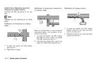
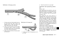
ROUTE GUIDANCE - If it is impossible to reach the destination or waypoints because of traffic regulations, etc. - If the only route to reach the destination or waypoints is extremely complicated. - If the destination, current vehicle position or waypoint is within the "Avoid Area". - If a part of the route is included in the "Avoid Area". . The following may occur when the route is displayed. - If you calculate a route on a main road, the starting point of the route may not exactly match the current vehicle location. - The endpoint of the route may not exactly match the destination. - If you calculate a route on a main road, the system may display a route from another main road. This may be because the position of the vehicle icon is not accurate. In this case, park the vehicle in a safe location and reset the vehicle icon, or continue driving to see if the position of the vehicle icon is automatically adjusted before recalculating the route. - There are cases in which the system shows an indirect route to reach the destination or waypoints, if you set them from stored or facility information. In order to correct this, you must be careful about the traffic direction, especially when lanes with different travel directions are shown separately, such as interchanges and service areas. - This system makes no distinction between limited traffic control and total control (blockage). It may show an indirect route even if the road is usable. - Even if the freeway preference is set to OFF, a route that uses the freeway may be suggested. - Even if the ferry preference is set to OFF, a route that uses a ferry line may be suggested. - Ferry lines, excluding those that are only for pedestrians, bicycles and motorcycles, are stored in this system. Take into consideration the travel time required and operational condition before deciding whether to use them or not. . INFO: The system will only announce street names when the system language is set to English. Street names are not announced when the system is set to Franc ¸ ais (French). BASICS OF VOICE GUIDANCE Voice guidance announces which direction to turn when approaching an intersection in which a turn is necessary. NOTE: . There may be some cases in which voice guidance and actual road conditions do not correspond. This may occur because of discrepancies between the actual road and the information on the map data, or it is due to the vehicle's speed. In case voice guidance does not correspond to the actual road conditions, follow the information obtained from traffic signs or notices on the road. Route guidance provided by the navigation system does not take carpool lane driving into consideration, especially when carpool lanes are separated from other road lanes. General system information 10-9 .
-
 1
1 -
2
-
3
-
4
-
5
-
6
-
7
-
8
-
9
-
10
-
11
-
12
-
13
-
14
-
15
-
16
-
17
-
18
-
19
-
20
-
21
-
22
-
23
-
24
-
25
-
26
-
27
-
28
-
29
-
30
-
31
-
32
-
33
-
34
-
35
-
36
-
37
-
38
-
39
-
40
-
41
-
42
-
43
-
44
-
45
-
46
-
47
-
48
-
49
-
50
-
51
-
52
-
53
-
54
-
55
-
56
-
57
-
58
-
59
-
60
-
61
-
62
-
63
-
64
-
65
-
66
-
67
-
68
-
69
-
70
-
71
-
72
-
73
-
74
-
75
-
76
-
77
-
78
-
79
-
80
-
81
-
82
-
83
-
84
-
85
-
86
-
87
-
88
-
89
-
90
-
91
-
92
-
93
-
94
-
95
-
96
-
97
-
98
-
99
-
100
-
101
-
102
-
103
-
104
-
105
-
106
-
107
-
108
-
109
-
110
-
111
-
112
-
113
-
114
-
115
-
116
-
117
-
118
-
119
-
120
-
121
-
122
-
123
-
124
-
125
-
126
-
127
-
128
-
129
-
130
-
131
-
132
-
133
-
134
-
135
-
136
-
137
-
138
-
139
-
140
-
141
-
142
-
143
-
144
-
145
-
146
-
147
-
148
-
149
-
150
-
151
-
152
-
153
-
154
-
155
-
156
-
157
-
158
-
159
-
160
-
161
-
162
-
163
-
164
-
165
-
166
-
167
-
168
-
169
-
170
-
171
-
172
-
173
-
174
-
175
-
176
-
177
-
178
-
179
-
180
-
181
-
182
-
183
-
184
-
185
-
186
-
187
-
188
-
189
-
190
-
191
-
192
-
193
-
194
-
195
-
196
-
197
-
198
-
199
-
200
-
201
-
202
-
203
-
204
-
205
-
 206
206 -
 207
207 -
 208
208 -
 209
209 -
 210
210 -
 211
211 -
 212
212 -
 213
213 -
 214
214 -
 215
215 -
 216
216 -
217
-
218
-
219
-
220
-
221
-
222
-
223
-
224
-
225
-
226
-
227
-
228
-
229
-
230
-
231
-
232
-
233
-
234
-
235
-
236
-
237
-
238
-
239
-
240
-
241
-
242
-
243
-
244
-
245
-
246
-
247
-
248
-
249
-
250
-
251
-
252
 |
 |
