2014 Nissan Pathfinder Navigation System Owner's Manual - Page 54
2014 Nissan Pathfinder Manual

Page 54 highlights
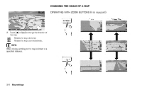
OPERATING WITH TOUCH OPERATION INFO: Free zoom: Once the [Small Step Zoom by Dial] is set to ON in the setting screen, the scale can be changed in smaller steps, when [ZOOM IN] or [ZOOM OUT] is pushed and held, than when either button is briefly pushed. If briefly pushed, operation returns to normal. Voice command Scale level for 2D map and BirdviewTM map (3D) display US Units 320 miles 80 miles 32 miles 8 miles 5 miles 2 miles 1 mile 1/2 mile 1/4 mile 1/8 mile 1/16 mile 1/32 mile 1/32 mile 1/64 mile Metric Units 640 km 160 km 64 km 16 km 10 km 4 km 2 km 1 km 500 m 200 m 100 m 50 m 50 m 25 m Normal Map 1. Touch . 1. Push located on the steering Displays the scale. 2. After the tone sounds, speak a command. To change the map scale: "Zoom In " (Alternate command mode) "Zoom Out " (Alternate command mode) Shows building footprint graphics MAP SCALE 2. Touch [ZOOM IN] or [ZOOM OUT] to change the scale. Any required map scale (map coverage) between 320 miles (640 km) and 1/64 of a mile (25 m) can be selected. Example: The most detailed level (2D map) 3-10 Map settings
-
 1
1 -
2
-
3
-
4
-
5
-
6
-
7
-
8
-
9
-
10
-
11
-
12
-
13
-
14
-
15
-
16
-
17
-
18
-
19
-
20
-
21
-
22
-
23
-
24
-
25
-
26
-
27
-
28
-
29
-
30
-
31
-
32
-
33
-
34
-
35
-
36
-
37
-
38
-
39
-
40
-
41
-
42
-
43
-
44
-
45
-
46
-
47
-
48
-
 49
49 -
 50
50 -
 51
51 -
 52
52 -
 53
53 -
 54
54 -
 55
55 -
 56
56 -
 57
57 -
 58
58 -
 59
59 -
60
-
61
-
62
-
63
-
64
-
65
-
66
-
67
-
68
-
69
-
70
-
71
-
72
-
73
-
74
-
75
-
76
-
77
-
78
-
79
-
80
-
81
-
82
-
83
-
84
-
85
-
86
-
87
-
88
-
89
-
90
-
91
-
92
-
93
-
94
-
95
-
96
-
97
-
98
-
99
-
100
-
101
-
102
-
103
-
104
-
105
-
106
-
107
-
108
-
109
-
110
-
111
-
112
-
113
-
114
-
115
-
116
-
117
-
118
-
119
-
120
-
121
-
122
-
123
-
124
-
125
-
126
-
127
-
128
-
129
-
130
-
131
-
132
-
133
-
134
-
135
-
136
-
137
-
138
-
139
-
140
-
141
-
142
-
143
-
144
-
145
-
146
-
147
-
148
-
149
-
150
-
151
-
152
-
153
-
154
-
155
-
156
-
157
-
158
-
159
-
160
-
161
-
162
-
163
-
164
-
165
-
166
-
167
-
168
-
169
-
170
-
171
-
172
-
173
-
174
-
175
-
176
-
177
-
178
-
179
-
180
-
181
-
182
-
183
-
184
-
185
-
186
-
187
-
188
-
189
-
190
-
191
-
192
-
193
-
194
-
195
-
196
-
197
-
198
-
199
-
200
-
201
-
202
-
203
-
204
-
205
-
206
-
207
-
208
-
209
-
210
-
211
-
212
-
213
-
214
-
215
-
216
-
217
-
218
-
219
-
220
-
221
-
222
-
223
-
224
-
225
-
226
-
227
-
228
-
229
-
230
-
231
-
232
-
233
-
234
-
235
-
236
-
237
-
238
-
239
-
240
-
241
-
242
-
243
-
244
-
245
-
246
-
247
-
248
-
249
-
250
-
251
-
252
 |
 |
