Audiovox NAV102 Operation Manual - Page 26
Setup - reviews
 |
View all Audiovox NAV102 manuals
Add to My Manuals
Save this manual to your list of manuals |
Page 26 highlights
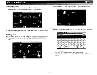
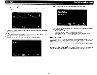
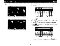
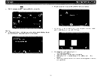
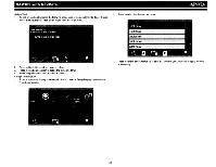
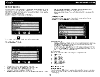
~ NAV102 with NavMate SETUP MENU When using the NAV102 for the first time, it is recommended that you customize the system parameter settings. For example, regarding navigation, you can choose to avoid or allow toll roads or ferries or change your map orientation. You can also edit display settings, including the display of on-screen navigation icons. To get started, press the Setup button on the "Main Menu". Auto Recalculation: Automatically recalculate the route if a wrong turn is made. Voice Guidance: When on, the system will give voice prompts. Announcement Tone: When on, the system will give a double tone to alert you of the next turn. Display Options To select which and how many icons are displayed on the map or to change the map orientation, press Display Options on the "Setup" menu. i i i You can always press the button to return to the previous screen. Setup Routing Criteria Heading Up/North Up Heading Up: This mode will display the map with the vehicle direction always pointing up. The map will rotate and move accordingly during navigation while the green arrow representing the vehicle stays up and still. North Up: This mode will display the map with North always pointing upward. The map will not rotate during navigation. The green arrow representing the vehicle will rotate and move according to the vehicle location on the map. On-Screen Icons Press to turn the display for any of the following icons or information on/off: Display Clock ETA Display Status Bar Display GPS Icon Display Scale Icon Display Compass Icon Display Next Maneuver Enlarged Intersection Shortest Time: Calculate route based on the fastest time. Avoid Freeway: Try not to use highways when calculating routes. Avoid Tolls: Do not use toll roads when calculating routes. Use Ferries: Use ferry travel when calculating routes. Simulation: Enable simulation mode (perform simulated navigation when not traveling). User Preferences Language Settings Press to choose from a list of available languages for on-screen text. Once a new language is selected, you will return the initial screen and be required to review safety information in the chosen language. 24
-
 1
1 -
2
-
3
-
4
-
5
-
6
-
7
-
8
-
9
-
10
-
11
-
12
-
13
-
14
-
15
-
16
-
17
-
18
-
19
-
20
-
 21
21 -
 22
22 -
 23
23 -
 24
24 -
 25
25 -
 26
26 -
 27
27 -
 28
28 -
 29
29 -
 30
30 -
 31
31 -
32
-
33
-
34
-
35
-
36
-
37
-
38
-
39
-
40
-
41
-
42
-
43
-
44
-
45
-
46
-
47
-
48
-
49
-
50
-
51
-
52
-
53
-
54
-
55
-
56
-
57
-
58
-
59
-
60
 |
 |
