Audiovox NAV102 Operation Manual - Page 3
Introduction - gps sd card
 |
View all Audiovox NAV102 manuals
Add to My Manuals
Save this manual to your list of manuals |
Page 3 highlights
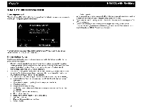
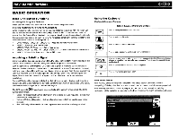
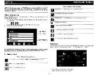
NAV102 with NavMate ~ INTRODUCTION We hope that you enjoy using your new Jensen NAV102 navigation system. This manual is designed to help you get the most out of your system. This navigation system leads you straight to your destination. You can navigate and plan your route with an easy-to-use and intuitive interface, plan your trip to suit your personal preferences and interests, and find and save (bookmark) interesting destinations before you begin your trip. Key Features Powered by Horizon NavMate Tele Atlas Map Data 11 million POI (Point Of Interest) Speed Sensitive Zoom Female/Male TIS Voice Guidance Female/Male Recorded Voice Guidance Turn by Turn Voice Guidance Back-Up Data DVD Specifications Samsung S3C2440 (ARM9) 400MHz Processor 64MB SDRAM 32MB Nand Flash Win CE4.2 Storage - External SD Card Slot (2GB Card Included w/ Map Data) Operating Voltage - Received from Head Unit (11 - 16VDC, Negative Ground) About GPS and GNSS The NAV102 uses a vehicle GPS (Global Positioning System)-based navigation device which utilizes digital map data to guide you from your selected location A to location B, using location information obtained from a Global Navigation Satellite System (GNSS). A GNSS consists of a set of satellites that transmit high-frequency radio signals containing time, direction, and distance data that can be picked up by a receiver, allowing users to pinpoint their precise locations anywhere around the globe. Navigation Satellite Receivers (GPS devices) use this transmitted information to calculate an exact location on the earth. Every point on Earth can be identified by latitude and longitude. The receiver uses the information sent by at least three satellites and determines the coordinates of the receiving device. By comparing the time the signals were transmitted from the satellites and the time they were recorded, the receiver calculates how far away each satellite is. The distance of the receiver from three or more satellites reflects its position on the surface of the planet. Using these distance measurements, the receiver might also be able to calculate speed, bearing, trip time, distance to destination, altitude, etc. The GPS position may be displayed as a point on a digital map (at least three satellites' signals must be received) and as the GPS device moves the corresponding trace is displayed as well. Please keep in mind that although the radio signals of navigation satellites will pass through clouds, glass, plastic, and other lightweight materials, satellite-navigation receivers will not work underground or in some enclosed spaces. Horizon NavMate Navigation / Tele Atlas Map Data The NAV102 2GB SD card is pre-loaded with Horizon NavMate engine and Tele Atlas map data. The map data covers the continental US, Alaska, Hawaii and Puerto Rico. The initial GPS location lock is best established when your vehicle is parked. If the device is in motion, the signal can take longer to initially connect. Once the initial coordinates are established, the software will follow you as you move and navigate. NOTE: It may take up to 5 minutes to establish the first connection. Subsequent connections will be faster (30 seconds to 1 minute), but if you have not used the unit for several days or are very far away from the last location you used it, it may take up to 5 minutes again to find a strong signal. 1
-
 1
1 -
 2
2 -
 3
3 -
 4
4 -
 5
5 -
 6
6 -
 7
7 -
 8
8 -
 9
9 -
10
-
11
-
12
-
13
-
14
-
15
-
16
-
17
-
18
-
19
-
20
-
21
-
22
-
23
-
24
-
25
-
26
-
27
-
28
-
29
-
30
-
31
-
32
-
33
-
34
-
35
-
36
-
37
-
38
-
39
-
40
-
41
-
42
-
43
-
44
-
45
-
46
-
47
-
48
-
49
-
50
-
51
-
52
-
53
-
54
-
55
-
56
-
57
-
58
-
59
-
60
 |
 |
