Panasonic CN-NVD905U Navigation Dvd Player - Page 28
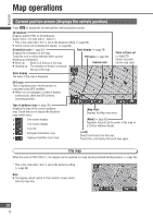
Map operations, Current position screen (displays the vehicle position
 |
UPC - 037988757947
View all Panasonic CN-NVD905U manuals
Add to My Manuals
Save this manual to your list of manuals |
Page 28 highlights
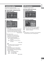
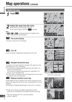
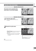
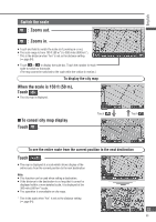
English Map operations Current position screen (displays the vehicle position) Press to display the current position (vehicle position) screen. 3D landmark Displays specific POIs as 3D landmarks. Scale: 150 ft - 0.5 mile (50 m - 500 m*) * This is the scale when "km" is set as the distance setting ( page 84). Screen can be set to display/not display. ( page 84) Orientation mark ( page 32) Clock display ( page 26) Displays the orientation of the map. Touch the icon to switch between North up and Heading up orientations. North up: North is at the top of the map. POI icons ( page 50) Vehicle mark Heading up: The direction of motion is towards the top of the map. Scale display The scale of the map is displayed. Zoom in/Zoom out ( page 33) Zooms in/zooms out the map scale. GPS mark This is displayed when vehicle position is calculated using GPS satellites. When it is not displayed, or when it flashes continuously, check the GPS antenna mounting position. Type of guidance map ( page 30) Displays the type of the current guidance map. Touch the icon to display the Guidance map switch menu. : One-screen display : Two-screen display : Turn list : Enlarged intersection map : Highway transition zoom map [Map view] Displays the Map view menu. [Mark] ( page 62) Registers the point at the center of the map as a Contact (Address Book). [] to display the touch keys again. City map When the scale is 150 ft (50 m*), the display can be switched to a map showing detailed building shapes. ( page 33) * This is the scale when "km" is set as the distance setting ( page 84). Note: The display cannot switch to that content in areas which lack city map data. 28 28
-
 1
1 -
2
-
3
-
4
-
5
-
6
-
7
-
8
-
9
-
10
-
11
-
12
-
13
-
14
-
15
-
16
-
17
-
18
-
19
-
20
-
21
-
22
-
 23
23 -
 24
24 -
 25
25 -
 26
26 -
 27
27 -
 28
28 -
 29
29 -
 30
30 -
 31
31 -
 32
32 -
 33
33 -
34
-
35
-
36
-
37
-
38
-
39
-
40
-
41
-
42
-
43
-
44
-
45
-
46
-
47
-
48
-
49
-
50
-
51
-
52
-
53
-
54
-
55
-
56
-
57
-
58
-
59
-
60
-
61
-
62
-
63
-
64
-
65
-
66
-
67
-
68
-
69
-
70
-
71
-
72
-
73
-
74
-
75
-
76
-
77
-
78
-
79
-
80
-
81
-
82
-
83
-
84
-
85
-
86
-
87
-
88
-
89
-
90
-
91
-
92
-
93
-
94
-
95
-
96
-
97
-
98
-
99
-
100
-
101
-
102
-
103
-
104
-
105
-
106
-
107
-
108
-
109
-
110
-
111
-
112
-
113
-
114
-
115
-
116
-
117
-
118
 |
 |
