Audiovox NVX430BT User Manual - Page 25
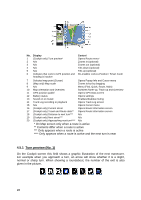
Marked map points (Pin), Visible POIs (Points of Interest)
 |
View all Audiovox NVX430BT manuals
Add to My Manuals
Save this manual to your list of manuals |
Page 25 highlights
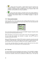
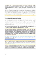
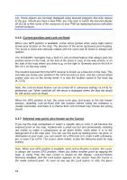
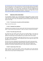
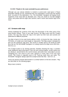
timeout The NVX430BT Navigator restores Lock-to-Position (5.6.3.3), and the Cursor jumps back to the current GPS position. 4.4.8 Marked map points (Pin) The Cursor can be marked with a pin. Pins are shown as being stuck in the map. A pin is visible at all zoom levels and remains in its position until you unpin it, or delete all pins in advanced settings (5.6.5.3). The NVX430BT Navigator automatically selects the color of the pin. Different colors help you identify a pin in the History list (6.2.2) later. There they are shown together with their address and GPS coordinates. Tip: A quick way to tell the coordinates of a location you found on the map is to pin it, and then look for the coordinates in the History list (6.2.2). This way you also save the coordinates with the pin for later reference. If you do not need the coordinates later, just select the point and start Find Coordinates (6.2.3). 4.4.9 Visible POIs (Points of Interest) The NVX430BT Navigator comes with thousands of built-in POIs, and you can create your own POI database as well. Having all of them displayed on the map would make the map too crowded. To avoid this, The NVX430BT Navigator lets you select which POIs to show and which ones to hide (4.7.2.4) using their categories and subcategories. Icons on the map represent pOIs. For a built-in POI it is the icon of the subcategory of the actual POI. For points you create, it is the icon you had chosen when you created the POI (it can be changed later). These icons are large enough to recognize the symbol, and semi-transparent so as not to cover the streets and junctions behind them. When the map is zoomed out, the icons are not shown. As you zoom in, small dots appear at the locations of visible POIs. Zooming in further makes the full icons appear. If two points are too close to each other so that icons overlap, a multi-POI icon is shown instead of individual ones. Zoom in more to see them separately. (Should the two POIs have the same icon, this icon will be displayed instead of the multi-POI icon.) Note: When navigating, POI icons can be disabled together with street names (5.2.4). If you still need this information during your journey, just drag the map to disable Lock-to-Position (4.5.4). This will restore street names and POI icons immediately. Now press Enter or tap Lock to reactivate Lock-to-Position. 25
-
 1
1 -
2
-
3
-
4
-
5
-
6
-
7
-
8
-
9
-
10
-
11
-
12
-
13
-
14
-
15
-
16
-
17
-
18
-
19
-
 20
20 -
 21
21 -
 22
22 -
 23
23 -
 24
24 -
 25
25 -
 26
26 -
 27
27 -
 28
28 -
 29
29 -
 30
30 -
31
-
32
-
33
-
34
-
35
-
36
-
37
-
38
-
39
-
40
-
41
-
42
-
43
-
44
-
45
-
46
-
47
-
48
-
49
-
50
-
51
-
52
-
53
-
54
-
55
-
56
-
57
-
58
-
59
-
60
-
61
-
62
-
63
-
64
-
65
-
66
-
67
-
68
-
69
-
70
-
71
-
72
-
73
-
74
-
75
-
76
-
77
-
78
-
79
-
80
-
81
-
82
-
83
-
84
-
85
-
86
-
87
-
88
-
89
 |
 |