Audiovox NVX430BT User Manual - Page 57
Show Street Labels, Textured Polygons, Sound settings, Master sound volume/switch
 |
View all Audiovox NVX430BT manuals
Add to My Manuals
Save this manual to your list of manuals |
Page 57 highlights
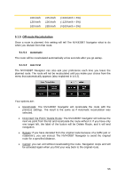
5.2.4 Show Street Labels You can set whether or not to see the names of the streets and the POI icons on the map when driving. Based on the current zoom and tilt levels, street names are displayed either aligned with the street or on signposts stuck into the streets (4.4.4). If you switch these signs on, it will be easier to recognize your location on the map, if you turn them off, it will be easier to see the road geometry. Note: You can only disable street names and POI icons if The NVX430BT Navigator follows your position. As soon as you move the map and Lock-to-Position (4.5.4) is disabled, street names and icons become visible again. Press Enter or tap Lock to re-enable Lock-to-Position and have the labels and icons disappear again. 5.2.5 Textured Polygons Enable textured polygons, and have rivers, lakes, forests and other large objects displayed in a more realistic and attractive way on the map. Disabling it will lead to uniform areas but better performance. See 4.4.5. 5.3 Sound settings Settings on this page determine the way The NVX430BT Navigator sounds. 5.3.1 Master sound volume/switch The loudness of The NVX430BT Navigator is independent of your PND settings. When you run The NVX430BT Navigator, the position of this fader determines the device volume level. When you exit the program, the device settings return. The left part of this control works as a mute button. Tap to mute all The NVX430BT Navigator sounds. This works in tandem with the Mute button (4.5.11) on the map screens. Switching one of them will change the status of the other. 57
-
 1
1 -
2
-
3
-
4
-
5
-
6
-
7
-
8
-
9
-
10
-
11
-
12
-
13
-
14
-
15
-
16
-
17
-
18
-
19
-
20
-
21
-
22
-
23
-
24
-
25
-
26
-
27
-
28
-
29
-
30
-
31
-
32
-
33
-
34
-
35
-
36
-
37
-
38
-
39
-
40
-
41
-
42
-
43
-
44
-
45
-
46
-
47
-
48
-
49
-
50
-
51
-
 52
52 -
 53
53 -
 54
54 -
 55
55 -
 56
56 -
 57
57 -
 58
58 -
 59
59 -
 60
60 -
 61
61 -
 62
62 -
63
-
64
-
65
-
66
-
67
-
68
-
69
-
70
-
71
-
72
-
73
-
74
-
75
-
76
-
77
-
78
-
79
-
80
-
81
-
82
-
83
-
84
-
85
-
86
-
87
-
88
-
89
 |
 |