Audiovox NVX430BT User Manual - Page 27
Roads in the route excluded by your preferences, Screens with map
 |
View all Audiovox NVX430BT manuals
Add to My Manuals
Save this manual to your list of manuals |
Page 27 highlights
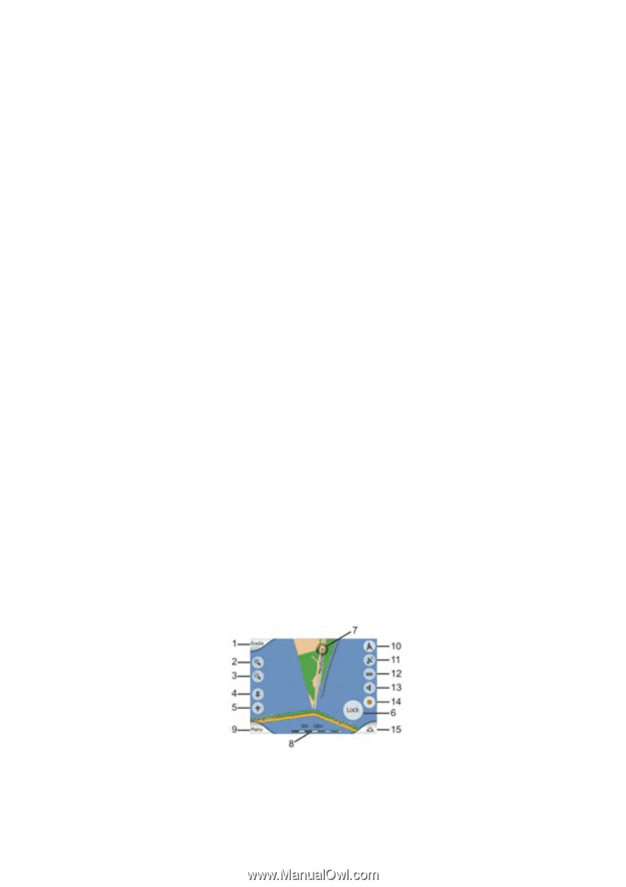
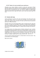
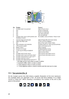
4.4.10.5 Roads in the route excluded by your preferences Although you can choose whether to include or avoid some road types in Route parameter settings (5.4.4), sometimes they are impossible to avoid near the starting point, via points or the destination. If so, The NVX430BT Navigator will display those segments of the route with an alternate color. They are shown in red with daylight colors, and yellow with the night color scheme, both in active and inactive legs of the route. 4.5 Screens with map Having explained the contents of the map, the description of the other parts of the map screens follows. There is two map screens: the Map screen and the Cockpit screen. The way they show the map is the same but their look and controls are optimized for different purposes. The Map screen is to be used mainly without a GPS, to browse the map, create user POI items, or to plan your route based on map points. The Map screen is designed to give you the maximum map area. This screen is usually used in 2D North-up mode (you can set The NVX430BT Navigator so it always opens the Map screen like that - see 5.6.1.1). The Cockpit screen is for driving purposes. Besides showing the map, it contains some additional travel information if you are just cruising (speed, current street your are driving in, speed limit for the current street), and some more route data if you are navigating (e.g. next street in your route, distance to travel, type of the next route event). This screen is typically used in 3D Track-up mode (you can make The NVX430BT Navigator always open the Cockpit screen like that - see 5.6.1.2). There are several controls that function in a similar fashion on the two screens. They are described on the following pages. Map screen contents: Cockpit screen contents: 27
-
 1
1 -
2
-
3
-
4
-
5
-
6
-
7
-
8
-
9
-
10
-
11
-
12
-
13
-
14
-
15
-
16
-
17
-
18
-
19
-
20
-
21
-
 22
22 -
 23
23 -
 24
24 -
 25
25 -
 26
26 -
 27
27 -
 28
28 -
 29
29 -
 30
30 -
 31
31 -
 32
32 -
33
-
34
-
35
-
36
-
37
-
38
-
39
-
40
-
41
-
42
-
43
-
44
-
45
-
46
-
47
-
48
-
49
-
50
-
51
-
52
-
53
-
54
-
55
-
56
-
57
-
58
-
59
-
60
-
61
-
62
-
63
-
64
-
65
-
66
-
67
-
68
-
69
-
70
-
71
-
72
-
73
-
74
-
75
-
76
-
77
-
78
-
79
-
80
-
81
-
82
-
83
-
84
-
85
-
86
-
87
-
88
-
89
 |
 |