Audiovox NVX430BT User Manual - Page 26
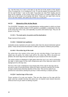
Elements of the Active Route, The start point, via points and the destination, Animated turn guidance
 |
View all Audiovox NVX430BT manuals
Add to My Manuals
Save this manual to your list of manuals |
Page 26 highlights
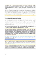
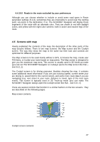
Tip: Tap the map on or near a POI item to see the list of the names of the nearest POIs in a popup list, if it is enabled (4.7.2.5). To see the details of a particular POI in the list, tap the blue 'i' icon on the right. If you have too may POIs nearby, this list may not be complete. In the Cursor menu (4.5.13) there is a button called POI that leads you to the screen of all nearby POI items. There you can open them one by one to see their details, and select any of them as a route point. 4.4.10 Elements of the Active Route The NVX430BT Navigator uses a multi-destination routing system in which you have a start point (your current location if GPS position is available), a destination, the line of the active leg of the route, and optionally via points and inactive legs. They are all shown on the map. 4.4.10.1 The start point, via points and the destination Flags represent these points. 4.4.10.2 Animated turn guidance Animated arrows represent all route events other than the above-mentioned special points. These arrows show the direction in which you need to continue your journey. 4.4.10.3 The active leg of the route The active leg is the section of the route you are currently driving. If you have not added any via points, the whole route will be the active leg. When via points are present, the active leg is the part leading from your location to the next via point. The active section is displayed in light green when the sun is up, and in red during the night. In both cases it is the most conspicuous part of the map even when in the background of a 3D map view. The line of the route is displayed on the driving side of the road for two-way and on the axis in case of one-way streets. When the map is zoomed in and the line is wide enough, small arrows show the direction of the route. This can be useful if you preview the route before starting the journey or when entering a complex junction. 4.4.10.4 Inactive legs of the route Future sections of a route are inactive. They are also shown on the map with the same color but a darker tint than the active one. An inactive route section becomes active as soon as you reach its starting via point. 26
-
 1
1 -
2
-
3
-
4
-
5
-
6
-
7
-
8
-
9
-
10
-
11
-
12
-
13
-
14
-
15
-
16
-
17
-
18
-
19
-
20
-
 21
21 -
 22
22 -
 23
23 -
 24
24 -
 25
25 -
 26
26 -
 27
27 -
 28
28 -
 29
29 -
 30
30 -
 31
31 -
32
-
33
-
34
-
35
-
36
-
37
-
38
-
39
-
40
-
41
-
42
-
43
-
44
-
45
-
46
-
47
-
48
-
49
-
50
-
51
-
52
-
53
-
54
-
55
-
56
-
57
-
58
-
59
-
60
-
61
-
62
-
63
-
64
-
65
-
66
-
67
-
68
-
69
-
70
-
71
-
72
-
73
-
74
-
75
-
76
-
77
-
78
-
79
-
80
-
81
-
82
-
83
-
84
-
85
-
86
-
87
-
88
-
89
 |
 |