Garmin G500 Pilots Guide - Page 120
Waypoint Information
 |
View all Garmin G500 manuals
Add to My Manuals
Save this manual to your list of manuals |
Page 120 highlights
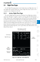
Foreword System Sec 1 3.5.2 Waypoint Information Page The Waypoint Information page provides details about a particular waypoint. You can show a waypoint by selecting it by Ident, Facility Name, or by City. The Map window shows the selected waypoint in the center of the map. The Range keys zoom in and out on the map. The Info window at the bottom of the display shows the Bearing and Distance from your present position to the selected waypoint as well as its region and Lat/Lon coordinates. The map window is set up with the same parameters as were selected for Navigation Map Page 1. Facility Identifier Facility Name Facility Location Facility Type Map Orientation PFD Sec 2 MFD Sec 3 Features Avoidance Hazard Sec 4 Map Window Additional Sec 5 & Alerts Annun. Sec 6 Symbols Sec 7 Appendix A Glossary Sec 8 Bearing & Distance to Wpt from Present Position Map Scale Map Region Lat/Lon Wpt Info Soft Key Wpt Weather Info Soft Key Figure 3-85 Flight Plan Waypoint Information Page NOTE: Waypoint information is shown on the second page of the Flight Plan page group. 3.5.2.1 Selecting a Waypoint 1) While viewing the Waypoint Information page of the FPL page group, press the MFD knob and use the large and small MFD knobs to select the identifier for the waypoint. 2) Press the ENT key to select the waypoint. 3) Use the RNG (Range) keys to zoom in or out on the map view. 3-56 Garmin G500 Pilot's Guide 190-01102-02 Rev. B Index Appendix B
-
 1
1 -
2
-
3
-
4
-
5
-
6
-
7
-
8
-
9
-
10
-
11
-
12
-
13
-
14
-
15
-
16
-
17
-
18
-
19
-
20
-
21
-
22
-
23
-
24
-
25
-
26
-
27
-
28
-
29
-
30
-
31
-
32
-
33
-
34
-
35
-
36
-
37
-
38
-
39
-
40
-
41
-
42
-
43
-
44
-
45
-
46
-
47
-
48
-
49
-
50
-
51
-
52
-
53
-
54
-
55
-
56
-
57
-
58
-
59
-
60
-
61
-
62
-
63
-
64
-
65
-
66
-
67
-
68
-
69
-
70
-
71
-
72
-
73
-
74
-
75
-
76
-
77
-
78
-
79
-
80
-
81
-
82
-
83
-
84
-
85
-
86
-
87
-
88
-
89
-
90
-
91
-
92
-
93
-
94
-
95
-
96
-
97
-
98
-
99
-
100
-
101
-
102
-
103
-
104
-
105
-
106
-
107
-
108
-
109
-
110
-
111
-
112
-
113
-
114
-
 115
115 -
 116
116 -
 117
117 -
 118
118 -
 119
119 -
 120
120 -
 121
121 -
 122
122 -
 123
123 -
 124
124 -
 125
125 -
126
-
127
-
128
-
129
-
130
-
131
-
132
-
133
-
134
-
135
-
136
-
137
-
138
-
139
-
140
-
141
-
142
-
143
-
144
-
145
-
146
-
147
-
148
-
149
-
150
-
151
-
152
-
153
-
154
-
155
-
156
-
157
-
158
-
159
-
160
-
161
-
162
-
163
-
164
-
165
-
166
-
167
-
168
-
169
-
170
-
171
-
172
-
173
-
174
-
175
-
176
-
177
-
178
-
179
-
180
-
181
-
182
-
183
-
184
-
185
-
186
-
187
-
188
-
189
-
190
-
191
-
192
-
193
-
194
-
195
-
196
-
197
-
198
-
199
-
200
-
201
-
202
-
203
-
204
-
205
-
206
-
207
-
208
-
209
-
210
-
211
-
212
-
213
-
214
-
215
-
216
-
217
-
218
-
219
-
220
-
221
-
222
-
223
-
224
-
225
-
226
-
227
-
228
-
229
-
230
-
231
-
232
-
233
-
234
-
235
-
236
-
237
-
238
-
239
-
240
-
241
-
242
-
243
-
244
-
245
-
246
-
247
-
248
-
249
-
250
-
251
-
252
-
253
-
254
-
255
-
256
-
257
-
258
-
259
-
260
-
261
-
262
-
263
-
264
-
265
-
266
-
267
-
268
-
269
-
270
-
271
-
272
-
273
-
274
-
275
-
276
-
277
-
278
-
279
-
280
-
281
-
282
-
283
-
284
-
285
-
286
-
287
-
288
-
289
-
290
 |
 |
