Garmin G500 Pilots Guide - Page 24
Secure Data Cards
 |
View all Garmin G500 manuals
Add to My Manuals
Save this manual to your list of manuals |
Page 24 highlights
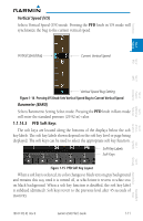
Foreword System Sec 1 PFD Sec 2 MFD Sec 3 Features Avoidance Hazard Sec 4 Additional Loss of GPS, magnetometer, or air data inputs is communicated to the pilot by message advisory alerts (refer to Section 6 for specific AHRS alert information). Any failure of the internal AHRS inertial sensors results in loss of attitude and heading information (indicated by red "X" flags over the corresponding flight instruments). A maximum of two GPS inputs are provided to the AHRS. If GPS information from one of the inputs fails, the AHRS uses the remaining GPS input and an alert message is issued to inform the pilot. If both GPS inputs fail, the AHRS will continue to provide attitude and heading information to the PFD as long as magnetometer and airspeed data are available and valid. If the magnetometer input fails, the AHRS continues to output valid attitude information and GPS Track information is used; however, the heading output on the PFD is flagged as invalid with a red "X," "TRK" in magenta is annunciated to the right of the Track value, and the Track value color is changed from white to magenta. NOTE: In this case the magnetic standby compass and GPS ground track can be used to keep the aircraft on the desired heading. Failure of the air data input has no effect on the AHRS output while AHRS is receiving valid GPS information. Invalid or unavailable airspeed data in addition to complete GPS failure results in loss of all attitude and heading information. 1.1.13 Secure Data Cards The G500 System uses Secure Digital (SD) cards to load and store various types of data. For basic flight operations, SD cards are required for Terrain, Obstacle, FliteChart, SafeTaxi, and ChartView database storage as well as Jeppesen aviation and ChartView database updates. The Navigation Database update card is generally inserted in the upper SD card slot for database updates and then removed. Other database cards are normally located in the lower SD card slot. NOTE: Ensure the GDU 620 is powered off before inserting or removing an SD card. NOTE: Refer to A-1 for instructions on updating the aviation database. Sec 5 & Alerts Annun. Sec 6 Symbols Sec 7 Appendix A Glossary Sec 8 Index Appendix B 1-8 Garmin G500 Pilot's Guide 190-01102-02 Rev. B
-
 1
1 -
2
-
3
-
4
-
5
-
6
-
7
-
8
-
9
-
10
-
11
-
12
-
13
-
14
-
15
-
16
-
17
-
18
-
 19
19 -
 20
20 -
 21
21 -
 22
22 -
 23
23 -
 24
24 -
 25
25 -
 26
26 -
 27
27 -
 28
28 -
 29
29 -
30
-
31
-
32
-
33
-
34
-
35
-
36
-
37
-
38
-
39
-
40
-
41
-
42
-
43
-
44
-
45
-
46
-
47
-
48
-
49
-
50
-
51
-
52
-
53
-
54
-
55
-
56
-
57
-
58
-
59
-
60
-
61
-
62
-
63
-
64
-
65
-
66
-
67
-
68
-
69
-
70
-
71
-
72
-
73
-
74
-
75
-
76
-
77
-
78
-
79
-
80
-
81
-
82
-
83
-
84
-
85
-
86
-
87
-
88
-
89
-
90
-
91
-
92
-
93
-
94
-
95
-
96
-
97
-
98
-
99
-
100
-
101
-
102
-
103
-
104
-
105
-
106
-
107
-
108
-
109
-
110
-
111
-
112
-
113
-
114
-
115
-
116
-
117
-
118
-
119
-
120
-
121
-
122
-
123
-
124
-
125
-
126
-
127
-
128
-
129
-
130
-
131
-
132
-
133
-
134
-
135
-
136
-
137
-
138
-
139
-
140
-
141
-
142
-
143
-
144
-
145
-
146
-
147
-
148
-
149
-
150
-
151
-
152
-
153
-
154
-
155
-
156
-
157
-
158
-
159
-
160
-
161
-
162
-
163
-
164
-
165
-
166
-
167
-
168
-
169
-
170
-
171
-
172
-
173
-
174
-
175
-
176
-
177
-
178
-
179
-
180
-
181
-
182
-
183
-
184
-
185
-
186
-
187
-
188
-
189
-
190
-
191
-
192
-
193
-
194
-
195
-
196
-
197
-
198
-
199
-
200
-
201
-
202
-
203
-
204
-
205
-
206
-
207
-
208
-
209
-
210
-
211
-
212
-
213
-
214
-
215
-
216
-
217
-
218
-
219
-
220
-
221
-
222
-
223
-
224
-
225
-
226
-
227
-
228
-
229
-
230
-
231
-
232
-
233
-
234
-
235
-
236
-
237
-
238
-
239
-
240
-
241
-
242
-
243
-
244
-
245
-
246
-
247
-
248
-
249
-
250
-
251
-
252
-
253
-
254
-
255
-
256
-
257
-
258
-
259
-
260
-
261
-
262
-
263
-
264
-
265
-
266
-
267
-
268
-
269
-
270
-
271
-
272
-
273
-
274
-
275
-
276
-
277
-
278
-
279
-
280
-
281
-
282
-
283
-
284
-
285
-
286
-
287
-
288
-
289
-
290
 |
 |
