Garmin GPSMAP 3210 Owner's Manual - Page 44
Viewing a Main in Full-Screen Mode, Map
 |
UPC - 753759053062
View all Garmin GPSMAP 3210 manuals
Add to My Manuals
Save this manual to your list of manuals |
Page 44 highlights
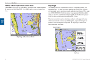
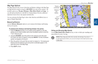
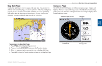
Main Pages Main Pages > Map Page Viewing a Main Page in Full-Screen Mode Use the DATA key to view the main page in full-screen mode, without functions, the status bar, or digital data fields. Press DATA again to return to the previous view. Map Page The Map Page provides comprehensive electronic cartography, plotting, and navigational data. The Map Page shows your boat on a digital chart, complete with geographic names, map items, navaids, and other chart features. When using your GPSMAP 3206/3210 with the optional preprogrammed BlueChart g2 data cards, you can view detailed roads and photographs. See the BlueChart g2 User's Guide for additional information about BlueChart g2 data. When the map pointer is active, information is shown in the upper-left corner of the map to indicate location, any identifying text, range, and bearing to the pointer or a selected waypoint or map item. The map range is shown in the lower-right corner of the map. Map information Map Page in Full-Screen Mode Map range 36 GPSMAP 3206/3210 Owner's Manual
-
 1
1 -
2
-
3
-
4
-
5
-
6
-
7
-
8
-
9
-
10
-
11
-
12
-
13
-
14
-
15
-
16
-
17
-
18
-
19
-
20
-
21
-
22
-
23
-
24
-
25
-
26
-
27
-
28
-
29
-
30
-
31
-
32
-
33
-
34
-
35
-
36
-
37
-
38
-
 39
39 -
 40
40 -
 41
41 -
 42
42 -
 43
43 -
 44
44 -
 45
45 -
 46
46 -
 47
47 -
 48
48 -
 49
49 -
50
-
51
-
52
-
53
-
54
-
55
-
56
-
57
-
58
-
59
-
60
-
61
-
62
-
63
-
64
-
65
-
66
-
67
-
68
-
69
-
70
-
71
-
72
-
73
-
74
-
75
-
76
-
77
-
78
-
79
-
80
-
81
-
82
-
83
-
84
-
85
-
86
-
87
-
88
-
89
-
90
-
91
-
92
-
93
-
94
-
95
-
96
-
97
-
98
-
99
-
100
-
101
-
102
-
103
-
104
-
105
-
106
-
107
-
108
-
109
-
110
-
111
-
112
-
113
-
114
-
115
-
116
-
117
-
118
-
119
-
120
-
121
-
122
-
123
-
124
-
125
-
126
-
127
-
128
-
129
-
130
 |
 |
