Garmin GPSMAP 3210 Owner's Manual - Page 77
Detail Sub Tab, Labels Sub Tab, Lat/Lon Grid
 |
UPC - 753759053062
View all Garmin GPSMAP 3210 manuals
Add to My Manuals
Save this manual to your list of manuals |
Page 77 highlights
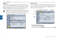
Detail Sub Tab Use the Detail sub tab to control the amount of detail for charts, waypoints, active routes, Tide Stations, services, saved tracks, and track logs shown on the Map Page. Main Menu > Map Tab Labels Sub Tab Use the Labels sub tab to select the screen size of the text for a given map item. Main Menu • Chart-controls how much map detail you see and which charts the unit chooses to use for a particular zoom range. Select Most, More, Normal, Less, or Least. • Chart, Waypoints, Active Route, Tide Stations, Services, Lat/Lon Grid-sets the maximum scale at which the feature should appear onscreen. Select Off, All Ranges, Auto, or
-
 1
1 -
2
-
3
-
4
-
5
-
6
-
7
-
8
-
9
-
10
-
11
-
12
-
13
-
14
-
15
-
16
-
17
-
18
-
19
-
20
-
21
-
22
-
23
-
24
-
25
-
26
-
27
-
28
-
29
-
30
-
31
-
32
-
33
-
34
-
35
-
36
-
37
-
38
-
39
-
40
-
41
-
42
-
43
-
44
-
45
-
46
-
47
-
48
-
49
-
50
-
51
-
52
-
53
-
54
-
55
-
56
-
57
-
58
-
59
-
60
-
61
-
62
-
63
-
64
-
65
-
66
-
67
-
68
-
69
-
70
-
71
-
 72
72 -
 73
73 -
 74
74 -
 75
75 -
 76
76 -
 77
77 -
 78
78 -
 79
79 -
 80
80 -
 81
81 -
 82
82 -
83
-
84
-
85
-
86
-
87
-
88
-
89
-
90
-
91
-
92
-
93
-
94
-
95
-
96
-
97
-
98
-
99
-
100
-
101
-
102
-
103
-
104
-
105
-
106
-
107
-
108
-
109
-
110
-
111
-
112
-
113
-
114
-
115
-
116
-
117
-
118
-
119
-
120
-
121
-
122
-
123
-
124
-
125
-
126
-
127
-
128
-
129
-
130
 |
 |

GPSMAP 3206/3210 Owner’s Manual
6
M
AIN
M
ENU
>
M
AP
T
AB
M
AIN
M
ENU
Detail Sub Tab
Use the Detail sub tab to control the amount of detail for charts, waypoints, active
routes, Tide Stations, services, saved tracks, and track logs shown on the Map
Page.
Chart
—controls how much map detail you see and which charts the unit
chooses to use for a particular zoom range. Select
Most
,
More
,
Normal
,
Less
, or
Least.
Chart
,
Waypoints
,
Active Route
,
Tide Stations
,
Services
,
Lat/Lon
Grid
—sets the maximum scale at which the feature should appear on-
screen. Select
Off
,
All Ranges
,
Auto
, or
<30 ft
to
<800 nm
.
NOTE:
Some types of data only show up to certain zoom scales.
•
•
Labels Sub Tab
Use the Labels sub tab to select the screen size of the text for a given map item.
Chart
,
Waypoints
,
Active Route
,
Tide Stations
,
Services
,
Spot
Soundings
,
Lat/Lon Grid
—controls the screen size of the text for a given
map item. Select
None
,
Small
,
Medium
, or
Large
.
•