Garmin GPSMAP 3210 Owner's Manual - Page 92
Graph Sub Tab, Color Scheme, Fish Symbols, Scale, Overlay, Corners, Basic
 |
UPC - 753759053062
View all Garmin GPSMAP 3210 manuals
Add to My Manuals
Save this manual to your list of manuals |
Page 92 highlights
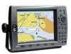
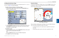
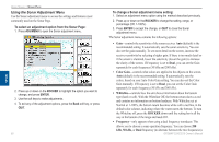
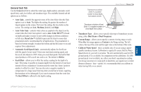
Using Sonar > Sonar Tab To calibrate the water speed: 1. On the Sonar tab, press the Cal Water Spd soft key. 2. Bring the boat to cruising speed. Both the top ground and uncalibrated water speeds are shown at the bottom of the calibration window. Note your top speed, stop the boat, and press ENTER. 3. By default, the top ground speed automatically appears in the "What was your top water speed?" field. If a ground speed is not available, the top uncalibrated water speed is used instead. If the new speed is correct, highlight OK, and press ENTER. If you want to manually enter a calibration, press ENTER on the speed field, enter a new speed, and press ENTER. Graph Sub Tab Use the Graph sub tab to select the color scheme, fish symbols, and scale. The available Graph sub tab options are: • Color Scheme-sets the colors for the Sonar and Flasher Pages. • Fish Symbols-sets how the Sonar Page interprets suspended targets and background information. If you select a fish symbol, the GPSMAP 3206/3210 identifies some returns for you by replacing them with fish symbols (in large, medium, and small sizes based on the size of the sonar return). If you are using dual beam, fish symbols from the narrow beam (directly underneath your boat) are solid, and the returns from the wide beam (out to the sides of your boat) are hollow. the Sonar Page does not interpret the sonar return data. Suspended targets appear as symbols. No background information appears Same as previous with the target depth shown. Suspended targets appear as symbols. Background information appears, making the distinction between fish and structure easier. Same as previous with target depth shown. • Scale-controls the appearance of the depth scale shown vertically along the right side of the graph. You can configure the depth scale to appear in one of four different ways: as an Overlay, in the Corners, Basic, or No Scale. Sonar 84 GPSMAP 3206/3210 Owner's Manual
-
 1
1 -
2
-
3
-
4
-
5
-
6
-
7
-
8
-
9
-
10
-
11
-
12
-
13
-
14
-
15
-
16
-
17
-
18
-
19
-
20
-
21
-
22
-
23
-
24
-
25
-
26
-
27
-
28
-
29
-
30
-
31
-
32
-
33
-
34
-
35
-
36
-
37
-
38
-
39
-
40
-
41
-
42
-
43
-
44
-
45
-
46
-
47
-
48
-
49
-
50
-
51
-
52
-
53
-
54
-
55
-
56
-
57
-
58
-
59
-
60
-
61
-
62
-
63
-
64
-
65
-
66
-
67
-
68
-
69
-
70
-
71
-
72
-
73
-
74
-
75
-
76
-
77
-
78
-
79
-
80
-
81
-
82
-
83
-
84
-
85
-
86
-
 87
87 -
 88
88 -
 89
89 -
 90
90 -
 91
91 -
 92
92 -
 93
93 -
 94
94 -
 95
95 -
 96
96 -
 97
97 -
98
-
99
-
100
-
101
-
102
-
103
-
104
-
105
-
106
-
107
-
108
-
109
-
110
-
111
-
112
-
113
-
114
-
115
-
116
-
117
-
118
-
119
-
120
-
121
-
122
-
123
-
124
-
125
-
126
-
127
-
128
-
129
-
130
 |
 |
