Garmin GPSMAP 3210 Owner's Manual - Page 78
AIS Sub Tab, AutoZoom, Accuracy Circle, Bearing Line, All Ranges, <30 ft, <800 nm, Course Line
 |
UPC - 753759053062
View all Garmin GPSMAP 3210 manuals
Add to My Manuals
Save this manual to your list of manuals |
Page 78 highlights
Main Menu > Map Tab Nav Sub Tab Use the Nav sub tab to show or hide certain navigational features on the Map Page and the scale at which they appear. • Course Line-sets the maximum zoom scale at which the course line appears on-screen. Select Auto, Off, or
-
 1
1 -
2
-
3
-
4
-
5
-
6
-
7
-
8
-
9
-
10
-
11
-
12
-
13
-
14
-
15
-
16
-
17
-
18
-
19
-
20
-
21
-
22
-
23
-
24
-
25
-
26
-
27
-
28
-
29
-
30
-
31
-
32
-
33
-
34
-
35
-
36
-
37
-
38
-
39
-
40
-
41
-
42
-
43
-
44
-
45
-
46
-
47
-
48
-
49
-
50
-
51
-
52
-
53
-
54
-
55
-
56
-
57
-
58
-
59
-
60
-
61
-
62
-
63
-
64
-
65
-
66
-
67
-
68
-
69
-
70
-
71
-
72
-
 73
73 -
 74
74 -
 75
75 -
 76
76 -
 77
77 -
 78
78 -
 79
79 -
 80
80 -
 81
81 -
 82
82 -
 83
83 -
84
-
85
-
86
-
87
-
88
-
89
-
90
-
91
-
92
-
93
-
94
-
95
-
96
-
97
-
98
-
99
-
100
-
101
-
102
-
103
-
104
-
105
-
106
-
107
-
108
-
109
-
110
-
111
-
112
-
113
-
114
-
115
-
116
-
117
-
118
-
119
-
120
-
121
-
122
-
123
-
124
-
125
-
126
-
127
-
128
-
129
-
130
 |
 |

´0
GPSMAP 3206/3210 Owner’s Manual
M
AIN
M
ENU
>
M
AP
T
AB
M
AIN
M
ENU
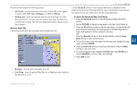
Nav Sub Tab
Use the Nav sub tab to show or hide certain navigational features on the Map
Page and the scale at which they appear.
AutoZoom
—toggles the automatic zoom on or off. When
On
, the map
automatically adjusts the map to a lower range as you approach your
destination point.
Accuracy Circle
—toggles the circle on or off. The circle represents the
approximate accuracy of the GPS position based on EPE (Estimated
Position Error) and map data quality. Your actual location is somewhere
within the circle.
Bearing Line
—sets the maximum scale at which the feature appears on the
screen and toggles the red/yellow line that continually points to the current
navigation point. Select
Off
,
All Ranges
,
Auto
, or
<30 ft
to
<800 nm
.
•
•
•
Course Line
—sets the maximum zoom scale at which the course line
appears on-screen. Select
Auto
,
Off
, or
<120 ft
to
<800 nm
.
Heading Line
—draws an extension from the end of the boat icon in the
direction of travel. For
Distance
, enter the numeric distance value to which
you want the line to extend. For
Time
, enter the numeric time value for
which you want the line to extend. The Time line length automatically
adjusts as your speed changes.
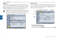
AIS Sub Tab
AIS (Automatic Identification System) alerts you to area traffic. AIS provides
ship IDs, position, course, and speed for ships equipped with a transponder within
range.
NOTE:
You must set your chartplotter communication to
NMEA In/NMEA
Out
with a baud rate of 38,400 to receive AIS information.
•
•