Garmin GPSMAP 3210 Owner's Manual - Page 50
Highway the bottom-center of the Highway Three-dimensional cartography provides - gps manual
 |
UPC - 753759053062
View all Garmin GPSMAP 3210 manuals
Add to My Manuals
Save this manual to your list of manuals |
Page 50 highlights
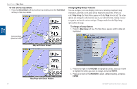
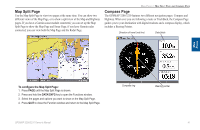
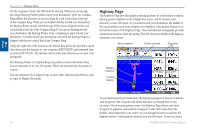
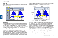
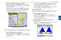
Main Pages Main Pages > Highway Page For the compass to work, the GPS must be moving. When you are moving, the orange Bearing Pointer points toward your destination, while the Compass Ring reflects the direction you are traveling by a red vertical line at the top of the Compass Ring. When you are headed directly toward your destination, the Bearing Pointer points toward the top of the screen, aligned with the red vertical line at the top of the Compass Ring. If you are not heading toward your destination, the Bearing Pointer turns, continuing to point toward your destination. To head toward your destination, turn until the Bearing Pointer is aligned with the red vertical line in the Compass Ring. Along the right side of the screen are the default data fields; the top field is speed. Also shown are the distance to your waypoint (DIST NEXT) and estimated time en route (ETE NEXT). The distance and en route time decrease as you near your destination. The Bearing Pointer or Compass Ring may point in various directions when you are stationary or at very low speeds. When you start moving, the pointer is correct. You can customize the Compass Page to show other functions and different sizes or types of Digital Data fields. Highway Page The Highway Page provides graphic steering guidance to a destination waypoint, placing greater emphasis on the straight-line course, and the distance and direction you are off course. As you head toward your destination, the middle of the screen guides you to your waypoint on a highway. Your present location is at the bottom-center of the Highway Page. Three-dimensional cartography provides situational awareness while navigating. The line down the middle of the highway represents your course. Route waypoint Current nav point Data fields Desired track line Current location As you head toward your destination, the highway perspective moves to indicate your progress to the waypoint and which direction you should steer to stay on course. If you are navigating a route, the Highway Page shows each route waypoint in sequence connected by a magenta "road" with a line down the middle, which represents your course. As you navigate toward a waypoint, the highway moves-indicating the direction you are off course. To stay on course, 42 GPSMAP 3206/3210 Owner's Manual
-
 1
1 -
2
-
3
-
4
-
5
-
6
-
7
-
8
-
9
-
10
-
11
-
12
-
13
-
14
-
15
-
16
-
17
-
18
-
19
-
20
-
21
-
22
-
23
-
24
-
25
-
26
-
27
-
28
-
29
-
30
-
31
-
32
-
33
-
34
-
35
-
36
-
37
-
38
-
39
-
40
-
41
-
42
-
43
-
44
-
 45
45 -
 46
46 -
 47
47 -
 48
48 -
 49
49 -
 50
50 -
 51
51 -
 52
52 -
 53
53 -
 54
54 -
 55
55 -
56
-
57
-
58
-
59
-
60
-
61
-
62
-
63
-
64
-
65
-
66
-
67
-
68
-
69
-
70
-
71
-
72
-
73
-
74
-
75
-
76
-
77
-
78
-
79
-
80
-
81
-
82
-
83
-
84
-
85
-
86
-
87
-
88
-
89
-
90
-
91
-
92
-
93
-
94
-
95
-
96
-
97
-
98
-
99
-
100
-
101
-
102
-
103
-
104
-
105
-
106
-
107
-
108
-
109
-
110
-
111
-
112
-
113
-
114
-
115
-
116
-
117
-
118
-
119
-
120
-
121
-
122
-
123
-
124
-
125
-
126
-
127
-
128
-
129
-
130
 |
 |
