Garmin GPSMAP 3210 Owner's Manual - Page 46
Selecting Map Ranges, Cartography, To select a map range
 |
UPC - 753759053062
View all Garmin GPSMAP 3210 manuals
Add to My Manuals
Save this manual to your list of manuals |
Page 46 highlights
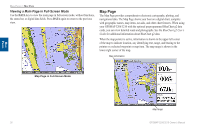
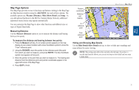
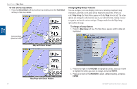
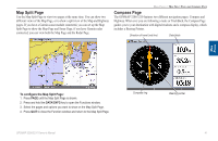
Main Pages Main Pages > Map Page Selecting Map Ranges The map display has 28 available range scales from 20 ft to 800 mi (5 m to 1200 km). The map range is controlled by the RANGE Up and RANGE Down keys, with the current range shown at the lower-right corner of the Map Page. Using Built-In Basemap Using BlueChart g2 Data Overzoom, no additional data To select a map range: Press the RANGE Up key to zoom out or the RANGE Down key to zoom in. Note: The scale value represents the distance from one end of the scale bar to the other. Cartography The GPSMAP 3206/3210 contains preloaded marine map detail using BlueChart® g2 technology. Coverage is for U.S. coastal areas, including Alaska and Hawaii. Features include integrated mapping, 2-D or mariner's eye map perspective, tide and current data, improved IALA symbols, navaids, marinas, boat ramps, roads, and more. The GPSMAP 3206/3210 accepts preprogrammed data cards and are compatible with the latest BlueChart® g2 series marine cartography. The unit shows cartography as long as there is chart information available for the selected range. Map coverage conforms to the following conditions: • Cartography appears when the selected zoom range is covered by either the internal database, or BlueChart g2 data. • When the selected zoom range is covered by both the internal database and BlueChart g2 data, the cartography with the best resolution appears. • When the selected zoom range exceeds the resolution of the data in use, overzoom cartography appears and an overzoom warning appears below the range. NOTE: The GPSMAP 3206/3210 is not compatible with Garmin BlueChart g2 Vision mapping data. 38 GPSMAP 3206/3210 Owner's Manual
-
 1
1 -
2
-
3
-
4
-
5
-
6
-
7
-
8
-
9
-
10
-
11
-
12
-
13
-
14
-
15
-
16
-
17
-
18
-
19
-
20
-
21
-
22
-
23
-
24
-
25
-
26
-
27
-
28
-
29
-
30
-
31
-
32
-
33
-
34
-
35
-
36
-
37
-
38
-
39
-
40
-
 41
41 -
 42
42 -
 43
43 -
 44
44 -
 45
45 -
 46
46 -
 47
47 -
 48
48 -
 49
49 -
 50
50 -
 51
51 -
52
-
53
-
54
-
55
-
56
-
57
-
58
-
59
-
60
-
61
-
62
-
63
-
64
-
65
-
66
-
67
-
68
-
69
-
70
-
71
-
72
-
73
-
74
-
75
-
76
-
77
-
78
-
79
-
80
-
81
-
82
-
83
-
84
-
85
-
86
-
87
-
88
-
89
-
90
-
91
-
92
-
93
-
94
-
95
-
96
-
97
-
98
-
99
-
100
-
101
-
102
-
103
-
104
-
105
-
106
-
107
-
108
-
109
-
110
-
111
-
112
-
113
-
114
-
115
-
116
-
117
-
118
-
119
-
120
-
121
-
122
-
123
-
124
-
125
-
126
-
127
-
128
-
129
-
130
 |
 |
