Nokia X6-00 User Guide - Page 114
Download and update maps, About positioning methods, Terrain view, Landmarks, Night mode - navigation internet
 |
View all Nokia X6-00 manuals
Add to My Manuals
Save this manual to your list of manuals |
Page 114 highlights
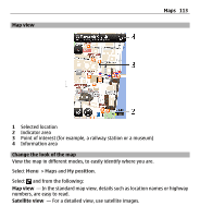
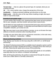
114 Maps Terrain view - View at a glance the ground type, for example, when you are traveling off-road. 3D - For a more realistic view, change the perspective of the map. Landmarks - Display prominent buildings and attractions on the map. Night mode - Dim the colors of the map. When traveling at night, the map is easier to read in this mode. Download and update maps To avoid cellular data transfer costs, download the latest maps and voice guidance files to your computer, and then transfer and save them to your device. Use the Nokia Ovi Suite application to download the latest maps and voice guidance files to your compatible computer. To download and install Nokia Ovi Suite on your compatible computer, go to www.ovi.com. Tip: Save new maps to your device before a journey, so you can browse the maps without an internet connection when traveling abroad. To make sure your device does not use an internet connection, in the main menu, select > Internet > Connection > Offline. About positioning methods Maps displays your location on the map using GPS, A-GPS, Wi-Fi, or cell ID based positioning. The Global Positioning System (GPS) is a satellite-based navigation system used for calculating your location. Assisted GPS (A-GPS) is a network service that sends you GPS data, improving the speed and accuracy of the positioning. Wi-Fi positioning improves position accuracy when GPS signals are not available, especially when you are indoors or between tall buildings. With cell ID based positioning, the position is determined through the antenna tower your cellular phone is currently connected to.
-
 1
1 -
2
-
3
-
4
-
5
-
6
-
7
-
8
-
9
-
10
-
11
-
12
-
13
-
14
-
15
-
16
-
17
-
18
-
19
-
20
-
21
-
22
-
23
-
24
-
25
-
26
-
27
-
28
-
29
-
30
-
31
-
32
-
33
-
34
-
35
-
36
-
37
-
38
-
39
-
40
-
41
-
42
-
43
-
44
-
45
-
46
-
47
-
48
-
49
-
50
-
51
-
52
-
53
-
54
-
55
-
56
-
57
-
58
-
59
-
60
-
61
-
62
-
63
-
64
-
65
-
66
-
67
-
68
-
69
-
70
-
71
-
72
-
73
-
74
-
75
-
76
-
77
-
78
-
79
-
80
-
81
-
82
-
83
-
84
-
85
-
86
-
87
-
88
-
89
-
90
-
91
-
92
-
93
-
94
-
95
-
96
-
97
-
98
-
99
-
100
-
101
-
102
-
103
-
104
-
105
-
106
-
107
-
108
-
 109
109 -
 110
110 -
 111
111 -
 112
112 -
 113
113 -
 114
114 -
 115
115 -
 116
116 -
 117
117 -
 118
118 -
 119
119 -
120
-
121
-
122
-
123
-
124
-
125
-
126
-
127
-
128
-
129
-
130
-
131
-
132
-
133
-
134
-
135
-
136
-
137
-
138
-
139
-
140
-
141
-
142
-
143
-
144
-
145
-
146
-
147
-
148
-
149
-
150
-
151
-
152
-
153
-
154
-
155
-
156
-
157
-
158
-
159
-
160
-
161
-
162
-
163
-
164
-
165
-
166
-
167
-
168
-
169
-
170
-
171
-
172
-
173
-
174
-
175
-
176
-
177
-
178
-
179
-
180
-
181
-
182
-
183
-
184
-
185
-
186
-
187
-
188
-
189
-
190
-
191
-
192
-
193
-
194
-
195
-
196
-
197
-
198
-
199
-
200
-
201
-
202
 |
 |