2012 Ford Explorer MyFord Touch/MyLincoln Touch Supplement 3rd Printing - Page 78
2012 Ford Explorer Manual

Page 78 highlights
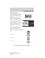
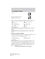
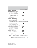
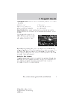
Navigation features 2D city maps show detailed outlines of buildings, visible land use and land elements and detailed railway infrastructure for the most essential cities around the globe. These 2D city maps also contain primary features such as town blocks, building footprints, and railways. 3D landmarks will appear when available on your current map. When in 3D map mode, these are clear, visible objects which are typically recognizable and have a certain tourist value. You can adjust how your map appears. Press the arrow icon repeatedly on the upper left side of the screen to choose between: • Heading up: Select for direction of forward travel to always be the upward direction on screen. Available for map scales up to 2.5 mi (5 km). For scales above that, the setting for Heading-Up is remembered, but the map is shown in North-Up only. If the scale returns below this level, then the Heading-Up setting is restored. • North up: In this mode, the northern direction is always the upward direction on screen. • 3D map mode: This map view provides an elevated perspective of the map. The viewing angle can be adjusted and the map can be rotated 180 degrees by dragging your finger along the circle tool that appears in the center of the map. Re-centering the map: Whenever you scroll the map away from your vehicle's current location, a centering icon will appear in the top left of the screen. Press this button to re-center the map back your vehicle's current location. 78 See End User License Agreement at the end of this book 2012 HMI-1 Gen 2 (fd1) Supplement, 4th Printing USA (fus)
-
 1
1 -
2
-
3
-
4
-
5
-
6
-
7
-
8
-
9
-
10
-
11
-
12
-
13
-
14
-
15
-
16
-
17
-
18
-
19
-
20
-
21
-
22
-
23
-
24
-
25
-
26
-
27
-
28
-
29
-
30
-
31
-
32
-
33
-
34
-
35
-
36
-
37
-
38
-
39
-
40
-
41
-
42
-
43
-
44
-
45
-
46
-
47
-
48
-
49
-
50
-
51
-
52
-
53
-
54
-
55
-
56
-
57
-
58
-
59
-
60
-
61
-
62
-
63
-
64
-
65
-
66
-
67
-
68
-
69
-
70
-
71
-
72
-
 73
73 -
 74
74 -
 75
75 -
 76
76 -
 77
77 -
 78
78 -
 79
79 -
 80
80 -
 81
81 -
 82
82 -
 83
83 -
84
-
85
-
86
-
87
-
88
-
89
-
90
-
91
-
92
-
93
-
94
-
95
-
96
-
97
-
98
-
99
-
100
-
101
-
102
-
103
 |
 |
