Garmin HTAWS User Guide
Garmin HTAWS Manual
 |
View all Garmin HTAWS manuals
Add to My Manuals
Save this manual to your list of manuals |
Garmin HTAWS manual content summary:
- Garmin HTAWS | User Guide - Page 1
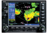
400W / 500W Series Garmin Optional Displays Pilot's Guide Addendum For: • GDL 69/69A XM Satellite Datalink • GTX 330/330D TIS • Garmin TAWS (GPS 500W & GNS 530W) • Garmin HTAWS (Helicopter Installations) • Terrain Proximity (Helicopter Installations) • Garmin GTS 8XX Series TAS - Garmin HTAWS | User Guide - Page 2
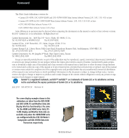
Garmin. Garmin hereby grants permission to download a single copy of this manual and of any revision to this manual Garmin Ltd. or its subsidiaries. July 2010 190-00356-30 Revision H The screen display examples shown in this addendum are taken from the GNS 430W and GNS 530W. TIS and Weather Data - Garmin HTAWS | User Guide - Page 3
Updates are released every 28 days. A database information packet is included in your Garmin 400W/500W Series Unit package. Pilots using an out-of-date database do so entirely at their own risk. CAUTION: The Weather Data Link, TIS, TAWS, HTAWS, and TERRAIN information contained in this Pilot's Guide - Garmin HTAWS | User Guide - Page 4
Service Traffic Data on TAWS Page 32 Inhibit Mode 34 External TAWS Inhibit Control 34 TAWS Manual Test 34 TAWS Symbols 35 General Database Information 36 Database Versions 36 Database Updates 37 Terrain/Obstacle Database Areas of Coverage 37 Section 3: TAWS Alerts 38 Forward Looking Terrain - Garmin HTAWS | User Guide - Page 5
Active Caution 49 HTAWS Manual Test 50 HTAWS Legend 50 HTAWS Symbols 51 General Database Information 52 Database Versions 52 Database Updates 53 Terrain Database Areas of Coverage 53 Obstacle Database Areas of Coverage 54 Section 3: HTAWS Alerts 54 Forward Looking Terrain Avoidance 55 - Garmin HTAWS | User Guide - Page 6
Introduction Table of Contents This page intentionally left blank iv 190-00356-30 Rev H - Garmin HTAWS | User Guide - Page 7
Control Radar Beacon System) Mode A and Mode C transponder-equipped aircraft within a specified service volume. The TIS ground sensor uses real-time track reports to generate traffic notification. TIS Traffic display is available to aircraft equipped with a Mode S Data Link such as the Garmin GTX - Garmin HTAWS | User Guide - Page 8
. Whenever the structure Garmin is not responsible for Mode S geographical coverage. Operation of the ground stations is the responsibility of the FAA. Refer to the Aeronautical Information Manual for a Terminal Mode S Radar Site Map covering the U.S. NOTE: TIS will be unavailable at low altitudes - Garmin HTAWS | User Guide - Page 9
. These are relatively rare occurrences and will be corrected in a few radar scans once the course has stabilized. Improving TIS Users of TIS can be reported in the following ways: • By telephone to the nearest Flight Service Station (FSS) facility. • By FAA Form 8000-7, Safety Improvement Report, - Garmin HTAWS | User Guide - Page 10
Advisories on the TIS display decreases and then increases, a new audio alert is sounded. The TIS audio alert is also generated whenever TIS service becomes unavailable. The volume, pitch, and duration of the audio alert (including the choice between a male or female voice) is configured during - Garmin HTAWS | User Guide - Page 11
coverage limitation due to a lineof-sight situation, a low altitude condition, no TIS service, or a result of flying directly over the radar site providing coverage (cone of silence). • NO DATA - "NO DATA" is displayed when no data are being received from the GTX 330. The pilot should be aware that - Garmin HTAWS | User Guide - Page 12
unit is on any page (other than the NAV Traffic Page or when a TAWS/Terrain, or Dead Reckoning pop-up is displayed) and a traffic threat is imminent or go back to the previous page by pressing CLR. Traffic Page TIS Traffic data are displayed on two 400W/500W Series unit pages, the Traffic Page and - Garmin HTAWS | User Guide - Page 13
four (500W Series) data fields on the right side of the Map Page. The Map Page displaying traffic. Configuring TIS Traffic Data on the Map Page traffic is displayed on the Map Page. Thumbnail Traffic displayed on the GNS 430W. NOTE: The thumbnail will display traffic coasting "TRFC CST" or traffic - Garmin HTAWS | User Guide - Page 14
Part One: Section 2 TIS Controls and Display Highlighting TIS Traffic Using Map Page Panning Another Map Page feature is panning, which allows you to move the map beyond its current limits without adjusting the map scale. When you select the panning function - by pressing the small right knob - a - Garmin HTAWS | User Guide - Page 15
the selected transponder. • UNAVAIL - When a 60 second period elapses with no data, TIS is considered to be unavailable. This state is indicated by the text situation, a low altitude condition, no TIS service, or a result of flying directly over the radar site providing coverage (cone of silence). - Garmin HTAWS | User Guide - Page 16
STBY) and operating (OPER) mode of operation to manually override automatic operation. To place the display into operating right knob to select "STBY?" 3. Press ENT to confirm. "DATA FAIL" Message The 'NO DATA' message indicates that data are not being received from the GTX 330. NOTE: This may - Garmin HTAWS | User Guide - Page 17
Activation Instructions and service if you are unable to locate the radio hardware IDs. Weather and/or audio data from your GDL 69/69A are provided by XM Satellite Radio, a company separate and independent from Garmin Terrain page. This page is like the map page, but can show NEXRAD weather data - Garmin HTAWS | User Guide - Page 18
Satellite Radio, the 400W/500W series unit can display the following aviation-related data: • NEXRAD. An indication of the intensity of weather radar echoes from the National Weather Service's network of NEXRAD (NEXt generation RADar) sites can be shown on the XM Weather Page and can optionally be - Garmin HTAWS | User Guide - Page 19
. In the unlikely event that the data should expire before a fresh update is received, the time will be dashed out and the data removed from the display. XM NEXRAD Weather The National Weather Service's network of WSR88D Doppler weather surveillance radars-also called NEXRAD, for Next Generation - Garmin HTAWS | User Guide - Page 20
right knob to highlight "Display US NEXRAD?" or "Display CN NEXRAD?," and then press ENT. (If "Hide US NEXRAD?" or "Hide CN NEXRAD?) appears, NEXRAD radar data are already enabled; just press MENU again to exit the Page Menu.) To display NEXRAD weather on the XM Weather page: 1. With the XM Weather - Garmin HTAWS | User Guide - Page 21
regarding displayed NEXRAD images. Some, but not all, causes of abnormal displayed information include: • Ground Clutter • Strobes and spurious radar data • Sun strobes, when the radar antenna points directly at the sun • Military aircraft deploy metallic dust which can cause alterations in - Garmin HTAWS | User Guide - Page 22
NEXRAD Limitations Certain limitations exist regarding the NEXRAD radar displays. Some, but not all, are data nor the age of the NEXRAD weather data are displayed at a zoom range of less than 10 NM. The resolution of displayed NEXRAD data update rate is every 12 minutes. 16 190-00356-30 Rev H - Garmin HTAWS | User Guide - Page 23
To display METARs on the XM Weather page: 1. While viewing the XM Weather page, check the upper left corner to see whether "METAR" or another weather product is displayed in the upper left corner. 2. If another weather product (rather than "METAR") is shown, press the small right (CRSR) knob to - Garmin HTAWS | User Guide - Page 24
Part Two: Section 2 XM Weather Textual METAR Page When the GDL 69/69A is installed, a Textual METAR page is added among the APT (airport) pages of the WPT page group. This page can be accessed from the XM Weather page as well as from the WPT page group. To display Textual METARs from the Nav XM - Garmin HTAWS | User Guide - Page 25
Part Two: Section 2 XM Weather Textual METAR/TAF Code The current airport weather reports on the Textual METAR page (and the airport weather forecasts on the TAF page, too) use a rather cryptic format originally devised for teleprinters. You can find information about this format in an FAA - Garmin HTAWS | User Guide - Page 26
Part Two: Section 2 XM Weather 3. Press ENT. The first item is the pop-up Page Menu will be "Review TFR?". NOTE: The full text of the NOTAM may be obtained from a local FSS or from the FAA web site, using the contents of this field as a reference to locate the particular NOTAM. However, the - Garmin HTAWS | User Guide - Page 27
Part Two: Section 2 XM Weather Cell Movement (CELL MOVE) When enabled, Cell Movement shows the storm cells identified by the ground-based system. The movement is depicted by an arrow. The tip of the arrow represents where the cell is expected to be in 10 minutes from the time the cell location was - Garmin HTAWS | User Guide - Page 28
are selected in the Winds Aloft Alt selection. The selected altitude is shown along with the product effective time. Winds Aloft predictions are updated every hour and are made available via the GDL 69/69A at a more frequent interval. The display includes: • Wind barbs, representing wind speed - Garmin HTAWS | User Guide - Page 29
any wind altitude from the ground up to 42,000 feet in 3,000 foot increments. When no data are shown at a given altitude, the data for that altitude has not been received. Wait for the next update. The selected altitude is depicted below the WINDS label. To change the XM Weather Winds Aloft - Garmin HTAWS | User Guide - Page 30
rather than a signal strength indication.) • Data ID. The Data ID field contains the eightcharacter ID code of the XM data radio built into the GDL 69 or GDL 500W-series only support a subset of the Aviator LT service from XM Satellite Radio. Product US NEXRAD CN NEXRAD Radar Coverage Precipitation - Garmin HTAWS | User Guide - Page 31
: that is, UTC (Coordinated Universal Time). Part Two: Section 4 XM Audio Section 4: XM Audio Audio entertainment is available through the XM Satellite Radio Service when activated in the optional installation of the GDL 69A. The 400W and 500W series units serve as the display and control head for - Garmin HTAWS | User Guide - Page 32
Part Two: Section 4 XM Audio The XM Audio page allows you to control the functions of the XM Audio receiver in the GDL 69A, such as, category and channel selection, artist selection, and volume. Pressing the MENU key displays the Page Menu selections. 3. Press ENT to select the highlighted category - Garmin HTAWS | User Guide - Page 33
XM Audio Menu The XM Audio Menu provides choices for selecting a channel, displaying the channel, artist, or title, enabling audio output, and controlling the volume. 1. While viewing the XM Audio page, press the MENU key. Part Two: Section 4 XM Audio 3. Turn the large right knob clockwise to move - Garmin HTAWS | User Guide - Page 34
Part Two: Section 4 XM Audio Enter Channel Number You may directly select a specific channel by using the "Enter Channel Number" item from the Page Menu. 1. While viewing the XM Audio page, press the MENU key. Turn the large right knob to highlight "Enter Channel Number." 2. Turn the large right - Garmin HTAWS | User Guide - Page 35
Part Two: Section 4 XM Audio Display Artist In List The name of the artists in the range of displayed channels can be shown in the middle pane by using the "Display Artist In List" item from the Page Menu. 1. While viewing the XM Audio page, press the MENU key. Turn the large right knob to - Garmin HTAWS | User Guide - Page 36
Part Two: Section 4 XM Audio Enable/Mute Audio Output The Enable/Mute Audio Output selection of the Page Menu allows you to toggle the audio output On or Off. When Audio Output is muted, a green slash will cross over the music symbol in the song pane. 1. While viewing the XM Audio page, press the - Garmin HTAWS | User Guide - Page 37
valid terrain/obstacle/ airport terrain database Limitations NOTE: The data contained in the terrain and obstacle databases comes from government agencies. Garmin accurately processes and cross-validates the data, but cannot guarantee the accuracy and completeness of the data. TAWS displays terrain - Garmin HTAWS | User Guide - Page 38
. GPSMSL altitude does not require local altimeter settings to determine MSL altitude. Therefore, GPS altitude provides a highly accurate and reliable MSL altitude source to calculate terrain and obstacle alerts. TAWS utilizes terrain and obstacle databases that are referenced to mean sea level - Garmin HTAWS | User Guide - Page 39
Select "Show (or Hide) Aviation Data?" and press ENT. Pressing the CLR key when the TAWS Page is displayed can also be used to toggle aviation information on or off. 120˚ Viewing Angle on the TAWS Page •360˚ View-View from above aircraft depicting surrounding terrain on all sides •120˚ View-View - Garmin HTAWS | User Guide - Page 40
using the Page Menu selection. TAWS Manual Test Garmin TAWS provides a manual test capability which verifies the proper operation of the aural and visual annunciations of the system prior to a flight. "Test TAWS" selection To manually test the TAWS system: 1. Select the TAWS Page and press MENU - Garmin HTAWS | User Guide - Page 41
above or within 100 ft below the aircraft altitude (Red) 1000 ft Terrain between 100 ft and 1000 ft below the aircraft altitude (Yellow) Terrain more than 1000 ft below the aircraft altitude (Black) TAWS Terrain Colors Unlighted Obstacle Lighted Obstacle < 1000 ft > 1000 ft < 1000 ft > 1000 - Garmin HTAWS | User Guide - Page 42
Impact Point Alert Level WARNING (Red) CAUTION (Yellow) TAWS Alert Coloring and Symbology General Database Information Garmin TAWS uses terrain and obstacle information supplied by government sources. The data undergoes verification by Garmin to confirm accuracy of the content, per TSO-C151b - Garmin HTAWS | User Guide - Page 43
Part Three: Section 2 TAWS Operation Database Updates Terrain/obstacle databases are updated periodically with the latest terrain and obstacle data. Visit the Garmin website to check for newer versions of terrain/ obstacle databases. Compare database cycle numbers to determine if a newer version is - Garmin HTAWS | User Guide - Page 44
(red) in nature and are described in further detail below. TAWS Annunciation Field Annunciations are color-coded according to the TAWS Alert Summary table. Pop-up terrain alerts can also appear during an alert, but only when the TAWS Page is not displayed. There are two options when an alert - Garmin HTAWS | User Guide - Page 45
Part Three: Section 3 TAWS Alerts WARNING- Estimated potential impact in approximately 15 seconds after a FLTA warning pop-up alert. FLTA warning pop-up alerts are accompanied by the aural message "Terrain, Terrain; Pull Up, Pull Up" or "Terrain Ahead, Pull Up; Terrain Ahead, Pull Up". Similarly, a - Garmin HTAWS | User Guide - Page 46
Part Three: Section 3 TAWS Alerts Excessive Descent Rate Alert (EDR) The purpose of the Excessive Descent Rate alert is to provide suitable notification when the aircraft is determined to be closing (descending) upon terrain at an excessive speed. The parameters for the alert as defined by TSO- - Garmin HTAWS | User Guide - Page 47
(EIGHT - Garmin HTAWS | User Guide - Page 48
, hardware status, and GPS status. If the terrain/obstacle database is not available, the aural message "TAWS System Failure" is issued along with the "TER FAIL" annunciation. "TERRAIN NOT AVAILABLE" Display TAWS FAILED Display TAWS Alert Summary The aural alert voice gender is configurable - Garmin HTAWS | User Guide - Page 49
None None None or Aural Message "TAWS System Failure" None "Terrain Not Available" "Sink Rate" "Pull Up" "Caution, Terrain; Caution, Terrain" or "Terrain Ahead; Terrain Ahead" Description TAWS has failed TAWS has been inhibited by flight crew TAWS not available Excessive Descent Rate Caution - Garmin HTAWS | User Guide - Page 50
the terrain or obstacle for avoidance. A TAWS warning may follow a TAWS caution unless the aircraft's path towards the terrain or obstacle is changed. NOTE: Display of terrain and obstacles on the display is supplemental data only. Maneuvering solely by reference to the terrain and obstacle data is - Garmin HTAWS | User Guide - Page 51
-corner for "HTAWS." Operating Criteria Garmin HTAWS requires the following to operate properly: • The system must have a valid 3D GPS position solution • The system must have a valid terrain/obstacle database. Limitations NOTE: The data contained in the terrain and obstacle databases comes from - Garmin HTAWS | User Guide - Page 52
. GPSMSL altitude does not require local altimeter settings to determine MSL altitude. Therefore, GPS altitude provides a highly accurate and reliable MSL altitude source to calculate terrain and obstacle alerts. HTAWS utilizes terrain and obstacle databases that are referenced to mean sea level - Garmin HTAWS | User Guide - Page 53
on or off. 120˚ Viewing Angle on the HTAWS Page • 360˚ View-View from above aircraft depicting surrounding terrain on all sides. • 120˚ View-View of terrain ahead of and 60˚ to either side of the aircraft flight path. Aviation Data NOTE: The HTAWS Page gives a "Track Up" display orientation, as - Garmin HTAWS | User Guide - Page 54
are inhibited. The annunciation is displayed in the terrain annunciator field whenever HTAWS is inhibited. NOTE: When the ground speed falls below 30 knots HTAWS will automatically display the "TAWS INHB" annunciation. This indicates that HTAWS is no longer providing CFIT protection. This automatic - Garmin HTAWS | User Guide - Page 55
"Reduce Protection?". 2. Press ENT. Protection is reduced. The "RP Mode" annunciation is displayed in the terrain annunciator field whenever protection is reduced. To enable full protection: 1. Select the HTAWS Page and press MENU. Turn the large or small right knob to highlight "Enable Full - Garmin HTAWS | User Guide - Page 56
Part Four: Section 2 HTAWS Operation HTAWS Manual Test Garmin HTAWS provides a manual test capability which verifies the proper operation of the aural and visual annunciations of the system prior to a flight. HTAWS Legend 1. Select the HTAWS Page and press MENU. Turn the large or small right knob - Garmin HTAWS | User Guide - Page 57
and colors in the following figures and table are used to represent obstacles and potential impact points on the HTAWS Page. Each color is associated with a height above terrain. The zoom range of obstacles (on the TAWS and NAV pages) is controlled by the NAV map's "Setup Map" menu option in the - Garmin HTAWS | User Guide - Page 58
Impact Point Alert Level WARNING (Red) CAUTION (Yellow) HTAWS Alert Coloring and Symbology General Database Information Garmin HTAWS uses terrain and obstacle information supplied by government sources. The data undergoes verification by Garmin to confirm accuracy of the content. However, the - Garmin HTAWS | User Guide - Page 59
and HTAWS. The databases required are: 1) 6 arc-second Terrain Database 2) Helicopter Obstacle Database 3) Helicopter Aviation Database including Heliports Database Updates Terrain/obstacle databases are updated periodically with the latest terrain and obstacle data. Visit the Garmin website - Garmin HTAWS | User Guide - Page 60
are necessarily charted and therefore may not be contained in the Obstacle Database. Section 3: HTAWS Alerts Alerts are issued when flight conditions meet parameters that are set within HTAWS software algorithms. HTAWS alerts employ either a CAUTION or a WARNING alert severity level. When an alert - Garmin HTAWS | User Guide - Page 61
information and the terrain and obstacle databases to provide alerts when the predicted flight path does not clear the terrain or obstacle by the NAV - HTAWS page map. The alerts are annunciated aurally through a voice message indicating the potential threat, such as "Caution - Terrain, Terrain" or " - Garmin HTAWS | User Guide - Page 62
" is issued along with the "TAWS FAIL" annunciation. "TAWS NOT AVAILABLE" Display Position Outside Terrain Database Coverage HTAWS FAILED Display HTAWS Alert Summary The aural alert voice gender is configurable to be either male or female. See your Garmin installer for further information on - Garmin HTAWS | User Guide - Page 63
to the terrain and obstacle data is not recommended or authorized. HTAWS Alerts Summary HTAWS Annunciation Pop-Up Alert None None None None None Aural Message "HTAWS System Failure" None "HTAWS Not Available" "Caution - Terrain, Terrain" "Warning - Terrain, Terrain" "Caution - Obstacle - Garmin HTAWS | User Guide - Page 64
Voice Call Out Selection The Voice Call Out (VCO) selection is available where HTAWS is installed. The VCO functionality provides a voice annunciation of the aircraft's height above terrain or the nearest airport, heliport, runway, or helipad when that threshold is first crossed. The available - Garmin HTAWS | User Guide - Page 65
be displayed on the Terrain Page around airports and heliports, to enhance locations. The Terrain legend (shown in the lower right of the display on the Terrain Page) defines heliports. Part Four: Section 3 Airport/Heliport Terrain "Cutouts" Airport and Heliport Cutouts NOTE: The - Garmin HTAWS | User Guide - Page 66
Part Four: Section 3 This page intentionally left blank 60 190-00356-30 Rev H - Garmin HTAWS | User Guide - Page 67
Part Five Terrain Proximity Part Five: Terrain Proximity Interface NOTE: Either the TERRAIN, TAWS (500W-series only), HTAWS, or Terrain Proximity functionality will be available via the Terrain page, depending on the installed hardware and configuration. . Introduction Garmin Terrain Proximity is - Garmin HTAWS | User Guide - Page 68
. The "View 120°" or "View 360°" option will be highlighted. Select the display of Aviation data on the Terrain Proximity page. The Page Menu selections allow you to hide or show aviation data overlay on the Terrain Proximity page. 1. Press the MENU key to display the Page Menu and turn the small - Garmin HTAWS | User Guide - Page 69
the Page Menu. 1. Press the MENU key to display the Page Menu and turn the small right knob to highlight the Legend selection. Part Five Terrain Proximity Select "Show Legend" 2. Press the ENT key to accept the displayed selection. Repeat these steps to toggle between the two selections - Garmin HTAWS | User Guide - Page 70
sources. The displayed information should never be understood as being allinclusive. NOTE: The data contained in the terrain and obstacle databases comes from government agencies. Garmin accurately processes and crossvalidates the data but cannot guarantee the accuracy and completeness of the - Garmin HTAWS | User Guide - Page 71
GTS 8XX Series Interface Introduction GTS 8XX Series Description Please refer to the GTS 8XX Series Pilot's Guide for a complete description of the GTS 8XX Series Traffic system. The Garmin GTS 8XX Series unit is a Traffic Advisory System (TAS - GTS 800 and GTS 820) or Traffic Alert and Collision - Garmin HTAWS | User Guide - Page 72
press ENT. Voice Announcements See the GTS 8XX Series Pilot's Guide for information on voice announcements. Switching Between Standby and Operating Modes range. If your aircraft has a squat switch and you do not manually switch out of standby, the GTS 8XX series unit will automatically switch - Garmin HTAWS | User Guide - Page 73
screen also displays unrestricted traffic (UNR) having a range of maximum specified by the GTS 8XX series unit Pilot's Guide. Please refer to the GTS 8XX series unit Pilot's Guide for Display Range Traffic Advisory (with no bearing information) Traffic Page +9,900 ft +2,700 ft +9,000 ft +2,700 - Garmin HTAWS | User Guide - Page 74
the user presses CLR). NOTE: GTS 8XX series unit data is only displayed on the Map Page if suitable aircraft heading data is available. See the Garmin 400W or 500W Series Installation Manuals available at your authorized Garmin service center for details. Traffic Page Display Range You can change - Garmin HTAWS | User Guide - Page 75
displayed as non-bearing banners on the Map Page. Selections for configuring traffic data are made from the Map Setup Menu on the Map Page. NOTE: Page, you can display traffic in a thumbnail format in any of the top three data fields (top four fields on the 500W Series) on the right side of the Map - Garmin HTAWS | User Guide - Page 76
Part Six GTS 800 Interface Highlighting Traffic Data Using Map Panning Another map page function is panning continued use of the GTS 8XX Series unit. Please see the GTS 8XX Series Pilot's Guide for detailed information on Failure Response. When the target pointer is placed on traffic, the traffic - Garmin HTAWS | User Guide - Page 77
- Garmin HTAWS | User Guide - Page 78
, Inc. 1200 East 151st Street, Olathe, Kansas 66062, U.S.A. Garmin AT, Inc. 2345 Turner Rd., S.E., Salem, Oregon 97302, U.S.A. Garmin (Europe) Ltd. Liberty House, Bulls Copse Road, Hounsdown Business Park, Southhampton, SO40 9RB, U.K. Garmin Corporation No. 68, Jangshu 2nd Road, Shijr, Taipei County
-
 1
1 -
 2
2 -
 3
3 -
 4
4 -
 5
5 -
 6
6 -
 7
7 -
8
-
9
-
10
-
11
-
12
-
13
-
14
-
15
-
16
-
17
-
18
-
19
-
20
-
21
-
22
-
23
-
24
-
25
-
26
-
27
-
28
-
29
-
30
-
31
-
32
-
33
-
34
-
35
-
36
-
37
-
38
-
39
-
40
-
41
-
42
-
43
-
44
-
45
-
46
-
47
-
48
-
49
-
50
-
51
-
52
-
53
-
54
-
55
-
56
-
57
-
58
-
59
-
60
-
61
-
62
-
63
-
64
-
65
-
66
-
67
-
68
-
69
-
70
-
71
-
72
-
73
-
74
-
75
-
76
-
77
-
78
 |
 |
400W / 500W Series
Garmin Optional Displays
Pilot’s Guide Addendum For:
• GDL 69/69A XM Satellite Datalink
• GTX 330/330D TIS
• Garmin TAWS (GPS 500W & GNS 530W)
• Garmin HTAWS (Helicopter Installations)
• Terrain Proximity (Helicopter Installations)
• Garmin GTS 8XX Series TAS