Garmin HTAWS User Guide - Page 43
Database, Coverage Area - taws terrain data updates
 |
View all Garmin HTAWS manuals
Add to My Manuals
Save this manual to your list of manuals |
Page 43 highlights
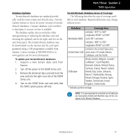
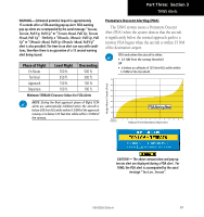
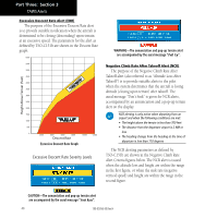
Part Three: Section 2 TAWS Operation Database Updates Terrain/obstacle databases are updated periodically with the latest terrain and obstacle data. Visit the Garmin website to check for newer versions of terrain/ obstacle databases. Compare database cycle numbers to determine if a newer version is available. The database update process includes either reprogramming or replacing the database card and inserting the updated card in the right card slot on the unit front panel. The terrain/obstacle database may be downloaded via the internet and the card reprogrammed using a USB programmer available from Garmin. Contact Garmin at 800-800-1020 or at www.garmin.com for more information. To update your terrain/obstacle databases: 1. Acquire a new terrain data card from Garmin. 2. Turn off the power to the 500W Series unit. 3. Remove the old terrain data card and insert the new card into the right-most slot of the 500W Series unit. 4. Turn on the 500W Series unit and verify that the TAWS system passes self-test. Terrain/Obstacle Database Areas of Coverage The following describes the area of coverage available in each database. Regional definitions may change without notice. Database Coverage Area Latitudes: N75° to S60° Longitudes: W180° to E180° Worldwide (WW) Cycle 09T1 and later: Latitudes: N90° to S90° Longitudes: W180° to E180° Limited to the United States plus United States (US) some areas of Canada, Mexico, Caribbean, and the Pacific. US/Europe Alaska, Austria, Belgium, Canada*, Caribbean*, Czech Republic, Denmark, Estonia, Finland, France, Germany, Greece, Hawaii, Iceland, Ireland, Italy, Latvia, Lithuania, Mexico*, Netherlands, Norway, Poland, Portugal, Slovakia, Spain, Sweden, Switzerland, United Kingdom, United States * Indicates partial coverage NOTE: It is very important to note that not all obstacles are necessarily charted and therefore may not be contained in the Obstacle Database. 190-00356-30 Rev H 37
-
 1
1 -
2
-
3
-
4
-
5
-
6
-
7
-
8
-
9
-
10
-
11
-
12
-
13
-
14
-
15
-
16
-
17
-
18
-
19
-
20
-
21
-
22
-
23
-
24
-
25
-
26
-
27
-
28
-
29
-
30
-
31
-
32
-
33
-
34
-
35
-
36
-
37
-
 38
38 -
 39
39 -
 40
40 -
 41
41 -
 42
42 -
 43
43 -
 44
44 -
 45
45 -
 46
46 -
 47
47 -
 48
48 -
49
-
50
-
51
-
52
-
53
-
54
-
55
-
56
-
57
-
58
-
59
-
60
-
61
-
62
-
63
-
64
-
65
-
66
-
67
-
68
-
69
-
70
-
71
-
72
-
73
-
74
-
75
-
76
-
77
-
78
 |
 |