Garmin HTAWS User Guide - Page 18
XM Weather
 |
View all Garmin HTAWS manuals
Add to My Manuals
Save this manual to your list of manuals |
Page 18 highlights
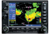
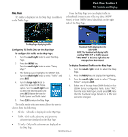
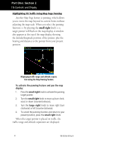
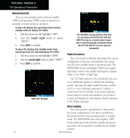
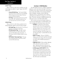
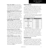
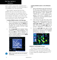
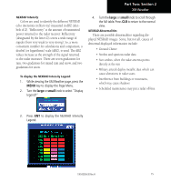
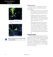
Part Two: Section 2 XM Weather XM WPT Pages Section 2: XM Weather When a GDL 69 or GDL 69A is installed, two XMrelated pages are added to "airport" pages in the WPT page group: • Textual METAR Page. The Textual METAR page shows the text of the most recent METAR (Meteorological Aerodrome Report) that has been received for an airport. • TAF Page. The TAF page shows the text of the most recent TAF (Terminal Aerodrome Forecast) that has been received for an airport. XM AUX Pages When a GDL 69 or GDL 69A is installed, the following XM pages appear in the AUX group of pages: • XM Audio Page (GDL 69A only). See Section 4 below for a description of this page. • XM Information Page. This page contains information that you will use when activating your XM satellite radio subscription. It also reports the GDL 69/69A's software version number. • XM Weather Timestamp Pages. This page show timestamp data for the most recently received XM weather data. The XM Weather Function is capable of displaying graphical weather information through the XM Satellite Radio Service when activated in the optional installation of the GDL 69/69A. Next Generation Weather Radar (NEXRAD), METARs symbols (METAR), Lightning (LTNG), Cell Movement (CELL MOVE), and Winds Aloft (WINDS) are displayed on the NAV pages. The types of products available depend on the subscription service with XM Satellite Radio. Once you have activated an aviation weather service from XM Satellite Radio, the 400W/500W series unit can display the following aviation-related data: • NEXRAD. An indication of the intensity of weather radar echoes from the National Weather Service's network of NEXRAD (NEXt generation RADar) sites can be shown on the XM Weather Page and can optionally be overlaid on the Map page. (Both these pages are in the NAV page group.) Canadian Radar may also be available. • Radar Coverage. Whenever NEXRAD is shown, a cross-hatch pattern indicates the limits of NEXRAD radar coverage. The cross-hatched area shows where NEXRAD information is unavailable. • Lightning (LTNG). When enabled, lightning strikes and cells are shown as yellow "+" signs. Lightning information indicates the location of cloud-to-ground lightning strikes. • Cell Movement (CELL MOVE). When enabled, Cell Movement shows the storm cells identified by the ground-based system. The movement is depicted by an arrow. The tip of the arrow represents where the cell is expected to be in 10 minutes from the time the cell location was determined. 12 190-00356-30 Rev H
-
 1
1 -
2
-
3
-
4
-
5
-
6
-
7
-
8
-
9
-
10
-
11
-
12
-
 13
13 -
 14
14 -
 15
15 -
 16
16 -
 17
17 -
 18
18 -
 19
19 -
 20
20 -
 21
21 -
 22
22 -
 23
23 -
24
-
25
-
26
-
27
-
28
-
29
-
30
-
31
-
32
-
33
-
34
-
35
-
36
-
37
-
38
-
39
-
40
-
41
-
42
-
43
-
44
-
45
-
46
-
47
-
48
-
49
-
50
-
51
-
52
-
53
-
54
-
55
-
56
-
57
-
58
-
59
-
60
-
61
-
62
-
63
-
64
-
65
-
66
-
67
-
68
-
69
-
70
-
71
-
72
-
73
-
74
-
75
-
76
-
77
-
78
 |
 |