Garmin HTAWS User Guide - Page 41
Obstacle Symbol
 |
View all Garmin HTAWS manuals
Add to My Manuals
Save this manual to your list of manuals |
Page 41 highlights
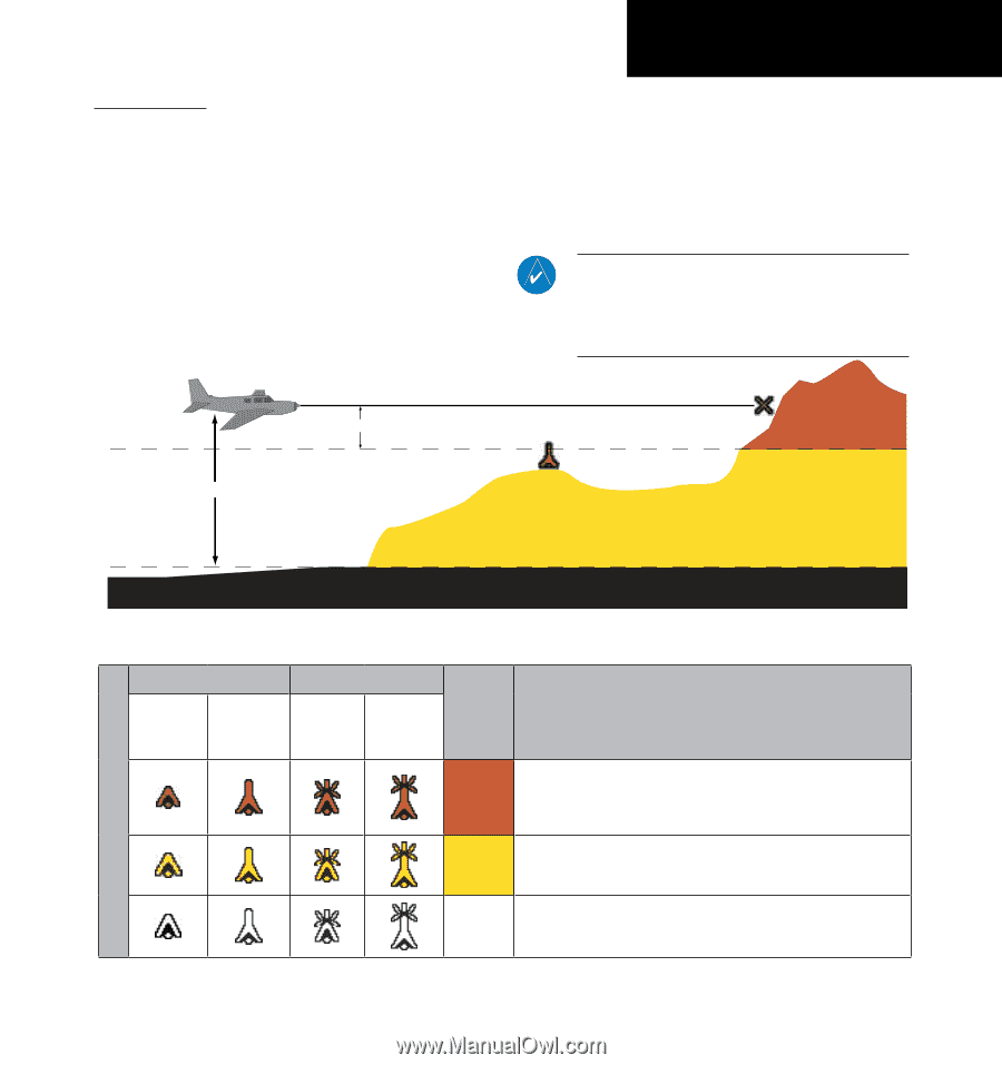
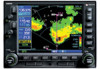
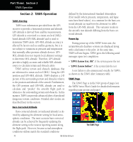
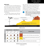
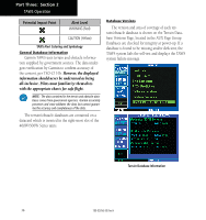
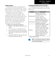
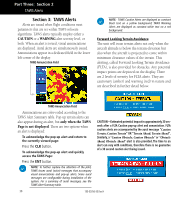
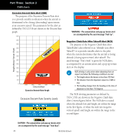
Part Three: Section 2 TAWS Operation TAWS Symbols The symbols and colors in the following figure and table are used to represent obstacles and potential impact points on the TAWS Page. TAWS uses yellow and red to depict terrain information relative to aircraft altitude. Each color is associated with an alert severity level. Terrain graphics and visual annunciations also use these color assignments. The zoom range of obstacles (on the TAWS and NAV pages) is controlled by the NAV map's "Setup Map" menu option in the "Terrain" group under the "Obstacles" option. Obstacles can be shown up to the maximum zoom range on the TAWS page. However, obstacles are ALWAYS shown on the TAWS page at 10 NM and below. Gray/White obstacles are shown on the Nav Map pages, but not on the TAWS page. NOTE: If an obstacle and the projected flight path of the aircraft intersect, the display automatically zooms in to the closest potential point of impact on the TAWS Page. 100 ft Threshold Projected Flight Path Unlighted Obstacle Potential Impact Point Terrain above or within 100 ft below the aircraft altitude (Red) 1000 ft Terrain between 100 ft and 1000 ft below the aircraft altitude (Yellow) Terrain more than 1000 ft below the aircraft altitude (Black) TAWS Terrain Colors Unlighted Obstacle Lighted Obstacle < 1000 ft > 1000 ft < 1000 ft > 1000 ft AGL AGL AGL AGL Color Obstacle Location Obstacle Symbol Red Obstacle at or within 100 ft below current aircraft altitude Yellow Obstacle between 100 ft and 1000 ft below current aircraft altitude White Obstacle is 1000 ft below current aircraft altitude TAWS Obstacle Colors and Symbology 190-00356-30 Rev H 35
-
 1
1 -
2
-
3
-
4
-
5
-
6
-
7
-
8
-
9
-
10
-
11
-
12
-
13
-
14
-
15
-
16
-
17
-
18
-
19
-
20
-
21
-
22
-
23
-
24
-
25
-
26
-
27
-
28
-
29
-
30
-
31
-
32
-
33
-
34
-
35
-
 36
36 -
 37
37 -
 38
38 -
 39
39 -
 40
40 -
 41
41 -
 42
42 -
 43
43 -
 44
44 -
 45
45 -
 46
46 -
47
-
48
-
49
-
50
-
51
-
52
-
53
-
54
-
55
-
56
-
57
-
58
-
59
-
60
-
61
-
62
-
63
-
64
-
65
-
66
-
67
-
68
-
69
-
70
-
71
-
72
-
73
-
74
-
75
-
76
-
77
-
78
 |
 |