Garmin HTAWS User Guide - Page 7
TIS Operation and, Symbology
 |
View all Garmin HTAWS manuals
Add to My Manuals
Save this manual to your list of manuals |
Page 7 highlights
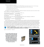
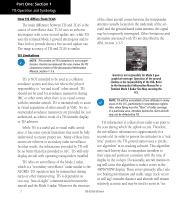
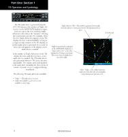
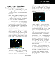
Part One: Section 1 TIS Operation and Symbology Part One: Traffic Information Service (TIS) Interface Section 1: TIS Operation and Symbology TIS Operation NOTE: Part One of this Addendum assumes the user has experience operating the 400W/500W Series units and the Garmin GTX 330 Transponder. The Traffic Information Service (TIS) provides a graphic display of traffic advisory information in the cockpit for non-TCAS (Traffic alert and Collision Avoidance System) equipped aircraft. TIS is a groundbased service providing relative location of all ATCRBS (Air Traffic Control Radar Beacon System) Mode A and Mode C transponder-equipped aircraft within a specified service volume. The TIS ground sensor uses real-time track reports to generate traffic notification. TIS Traffic display is available to aircraft equipped with a Mode S Data Link such as the Garmin GTX 330 Transponder. TIS Traffic from a GTX 330 Transponder can then be displayed on a Garmin 400W/500W Series unit. Surveillance data includes all transponderequipped aircraft within the coverage volume. Aircraft without an operating transponder are invisible to TIS. TIS displays up to eight traffic targets within seven nautical miles horizontally from 3000 feet below to 3500 feet above the requesting aircraft. • Your aircraft must be equipped with a Mode S data link transponder, such as the GTX 330. • You must be within range of a Mode S radar that provides the TIS service. Not all Mode S ground radars provide TIS service. • The "intruder" aircraft must be equipped with a transponder, and that transponder must be turned on. Aircraft that are not equipped with operating transponders will not be visible to the Mode S surveillance radar. • The "intruder" aircraft must be within the TIS coverage volume for your aircraft. TIS displays up to eight traffic targets within seven nautical miles horizontally from the requesting aircraft, and from 3,000 feet below to 3,500 feet above the requesting aircraft. • Both your aircraft and the intruder aircraft must be visible to the Mode S surveillance radar on the ground. Always remember that TIS cannot alert you to the presence of aircraft that are not equipped with transponders, nor can it alert you to aircraft that may be nearby, but obscured from the ground surveillance radar by intervening terrain. 7.0 nm 3,500 ft 3,000 ft TIS Coverage Volume (not to scale) The TIS is a ground-based service that displays nearby aircraft on your 400W/500W-series display. For the TIS feature to inform you of a nearby aircraft's presence, several conditions must be met: 190-00356-30 Rev H 1
-
 1
1 -
 2
2 -
 3
3 -
 4
4 -
 5
5 -
 6
6 -
 7
7 -
 8
8 -
 9
9 -
 10
10 -
 11
11 -
 12
12 -
13
-
14
-
15
-
16
-
17
-
18
-
19
-
20
-
21
-
22
-
23
-
24
-
25
-
26
-
27
-
28
-
29
-
30
-
31
-
32
-
33
-
34
-
35
-
36
-
37
-
38
-
39
-
40
-
41
-
42
-
43
-
44
-
45
-
46
-
47
-
48
-
49
-
50
-
51
-
52
-
53
-
54
-
55
-
56
-
57
-
58
-
59
-
60
-
61
-
62
-
63
-
64
-
65
-
66
-
67
-
68
-
69
-
70
-
71
-
72
-
73
-
74
-
75
-
76
-
77
-
78
 |
 |