Garmin HTAWS User Guide - Page 51
Part Four, HTAWS Interface
 |
View all Garmin HTAWS manuals
Add to My Manuals
Save this manual to your list of manuals |
Page 51 highlights
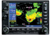
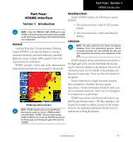
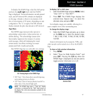
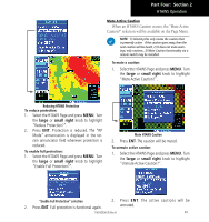
Part Four: Section 1 HTAWS Introduction Part Four: HTAWS Interface Section 1: Introduction NOTE: Either the TERRAIN, TAWS (500W-series only), HTAWS, or Terrain Proximity functionality will be available via the Terrain page, depending on the installed hardware and configuration. Overview Garmin's Helicopter Terrain Awareness Warning System (HTAWS) is an optional feature to increase situational awareness and aid in reducing controlled flight into terrain. Garmin TAWS satisfies TSO-C194 requirements for certification. HTAWS provides visual and aural annunciations when terrain and obstacles are a hazard to the aircraft. HTAWS Page with Terrain Alert NOTE: HTAWS-enabled units can be identified by observing the power-up screens. HTAWS-enabled units will display "HTAWS" after the model number. HTAWS-enabled units can also be identified by going to the Terrain page and checking the upper left-corner for "HTAWS." Operating Criteria Garmin HTAWS requires the following to operate properly: • The system must have a valid 3D GPS position solution • The system must have a valid terrain/obstacle database. Limitations NOTE: The data contained in the terrain and obstacle databases comes from government agencies. Garmin accurately processes and cross-validates the data, but cannot guarantee the accuracy and completeness of the data. HTAWS displays terrain and obstructions relative to the flight path of the aircraft. Individual obstructions may be shown if available in the database. However, all obstructions may not be available in the database and data may be inaccurate. Never use this information for navigation. Terrain information is based on terrain elevation data contained in a database that may contain inaccuracies. Terrain information should be used as an aid to situational awareness. Never use it for navigation or to maneuver to avoid terrain. HTAWS uses terrain and obstacle information supplied by government sources. The data undergoes verification by Garmin to confirm accuracy of the content. However, the displayed information should never be understood as being all-inclusive. 190-00356-30 Rev H 45
-
 1
1 -
2
-
3
-
4
-
5
-
6
-
7
-
8
-
9
-
10
-
11
-
12
-
13
-
14
-
15
-
16
-
17
-
18
-
19
-
20
-
21
-
22
-
23
-
24
-
25
-
26
-
27
-
28
-
29
-
30
-
31
-
32
-
33
-
34
-
35
-
36
-
37
-
38
-
39
-
40
-
41
-
42
-
43
-
44
-
45
-
 46
46 -
 47
47 -
 48
48 -
 49
49 -
 50
50 -
 51
51 -
 52
52 -
 53
53 -
 54
54 -
 55
55 -
 56
56 -
57
-
58
-
59
-
60
-
61
-
62
-
63
-
64
-
65
-
66
-
67
-
68
-
69
-
70
-
71
-
72
-
73
-
74
-
75
-
76
-
77
-
78
 |
 |
