Garmin HTAWS User Guide - Page 75
GTS 800 Interface
 |
View all Garmin HTAWS manuals
Add to My Manuals
Save this manual to your list of manuals |
Page 75 highlights
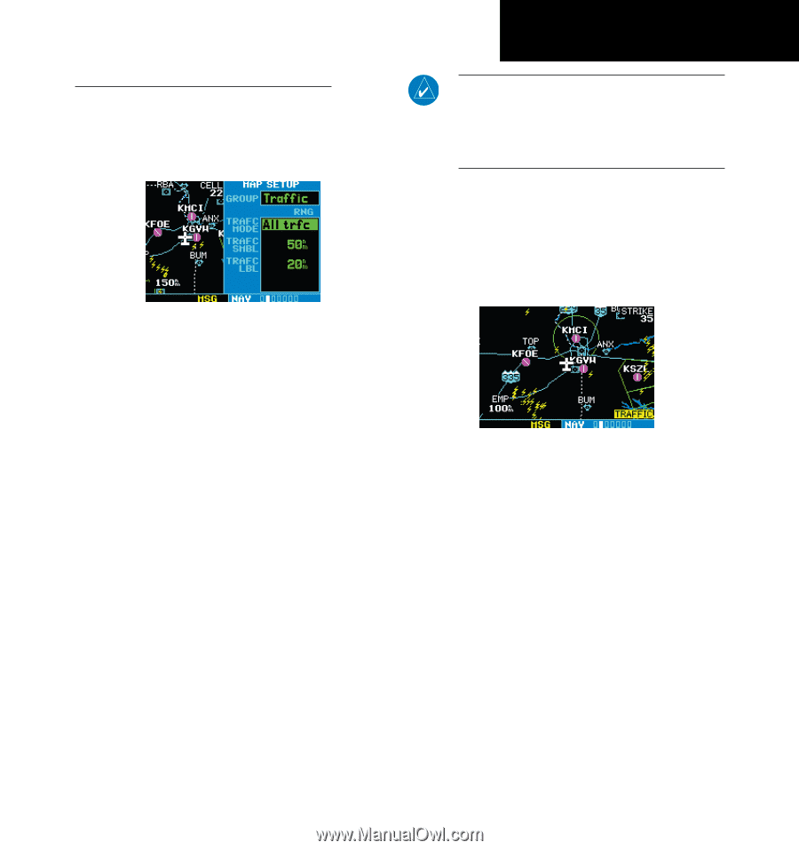
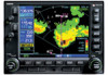
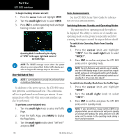
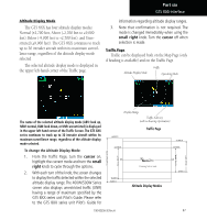
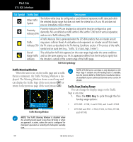
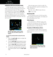
Part Six GTS 800 Interface Configuring Traffic Data on the Map Page Traffic is only displayed on the Map Page if aircraft heading data is available. When heading is not available, Traffic Advisories are displayed as non-bearing banners on the Map Page. Selections for configuring traffic data are made from the Map Setup Menu on the Map Page. NOTE: Proximity Advisories (PA) are displayed as solid white diamonds (may be configured as cyan). The GTS 800 shows these PAs as "other" (hollow diamonds). PAs are defined as traffic within the 6.0-NM range, with ± 1200 feet of altitude separation, and not a traffic advisory (TA). The traffic label is the altitude separation above or below the symbol and the vertical speed sense arrow to the right of the symbol. From the Map Page, you can display traffic in a thumbnail format in any of the top three data fields (top four fields on the 500W Series) on the right side of the Map Page. To configure traffic on the Map Page: 1. Turn the small right knob to select the Map Page. 2. Press MENU to display the Page Menu. Turn the small right knob to select "Setup Map?" and press ENT. 3. The flashing cursor highlights the GROUP field. Turn the small right knob to select Traffic and press ENT. 4. Turn the large right knob to select the desired Traffic Mode option. Turn the small right knob to select the desired option and press ENT. Repeat the step for Traffic Symbol and Traffic Label. 5. Return to the Map Page by pressing CLR. Traffic mode allows the operator to choose which traffic is displayed (all traffic, traffic and proximity advisories, or traffic advisories only). The traffic symbol is the symbol used to depict the type of traffic: When a Traffic Advisory is active, the "Traffic" banner is displayed in the lower right corner of the Map Page. To display Thumbnail Traffic on the Map Page 1. Turn the small right knob to select the Map Page. 2. Press MENU to display the Page Menu. 3. Turn the small right knob to select "Change Fields?" and press ENT. 4. Select one of the top three fields (top four fields on the 500W Series). Select TRFC from the Select Field Type List and press ENT. Note that the thumbnail range defaults to 6 NM and cannot be changed. 190-00356-30 Rev H 69
-
 1
1 -
2
-
3
-
4
-
5
-
6
-
7
-
8
-
9
-
10
-
11
-
12
-
13
-
14
-
15
-
16
-
17
-
18
-
19
-
20
-
21
-
22
-
23
-
24
-
25
-
26
-
27
-
28
-
29
-
30
-
31
-
32
-
33
-
34
-
35
-
36
-
37
-
38
-
39
-
40
-
41
-
42
-
43
-
44
-
45
-
46
-
47
-
48
-
49
-
50
-
51
-
52
-
53
-
54
-
55
-
56
-
57
-
58
-
59
-
60
-
61
-
62
-
63
-
64
-
65
-
66
-
67
-
68
-
69
-
 70
70 -
 71
71 -
 72
72 -
 73
73 -
 74
74 -
 75
75 -
 76
76 -
 77
77 -
 78
78
 |
 |