Garmin HTAWS User Guide - Page 28
Part Two:
 |
View all Garmin HTAWS manuals
Add to My Manuals
Save this manual to your list of manuals |
Page 28 highlights
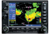
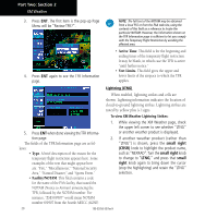
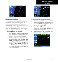
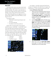
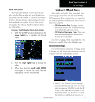
Part Two: Section 3 XM Weather Winds Aloft The Winds Aloft selection provides the pilot with a graphic display of predicted winds at any one of 15 selectable altitudes. The winds at a given altitude are selected in the Winds Aloft Alt selection. The selected altitude is shown along with the product effective time. Winds Aloft predictions are updated every hour and are made available via the GDL 69/69A at a more frequent interval. The display includes: • Wind barbs, representing wind speed, and direction • The selected altitude • The effective time for the prediction. Winds Aloft are represented by meteorological symbols known as "wind barbs". A wind barb consists of an arrow-like line that indicates the direction in which the wind is blowing, with marks ("barbs") along one side of the line to indicate wind speed. The barbed end of the symbol points in the direction from which the wind is coming. Barbs, which are used singly and in combinations, have the following values: • A short line: 5 knots • A long line: 10 knots • A pennant (triangle): 50 knots For example, a vertically oriented wind barb with a pennant, two long lines and a short line at its upper end would denote a 75-knot wind blowing from the north. To view XM Weather Winds Aloft: 1. While viewing the XM Weather page, check the upper left corner of the display. If a weather product other than "WINDS" is shown, press the small right (CRSR) knob to highlight the product name. Turn the small right knob until "WINDS" is displayed. 2. Turn the large right knob to move the cursor down to the Altitude field, then use the small right knob to select an altitude from ground level up to 42,000 feet (in 3,000-foot increments). Note that you can move up and down the atmosphere, comparing wind predictions at different altitudes. 3. When done, press the small right (CRSR) knob again to remove the cursor (remove highlighting from the altitude field). 22 190-00356-30 Rev H
-
 1
1 -
2
-
3
-
4
-
5
-
6
-
7
-
8
-
9
-
10
-
11
-
12
-
13
-
14
-
15
-
16
-
17
-
18
-
19
-
20
-
21
-
22
-
 23
23 -
 24
24 -
 25
25 -
 26
26 -
 27
27 -
 28
28 -
 29
29 -
 30
30 -
 31
31 -
 32
32 -
 33
33 -
34
-
35
-
36
-
37
-
38
-
39
-
40
-
41
-
42
-
43
-
44
-
45
-
46
-
47
-
48
-
49
-
50
-
51
-
52
-
53
-
54
-
55
-
56
-
57
-
58
-
59
-
60
-
61
-
62
-
63
-
64
-
65
-
66
-
67
-
68
-
69
-
70
-
71
-
72
-
73
-
74
-
75
-
76
-
77
-
78
 |
 |