Pioneer AVIC-X920BT Owner's Manual - Page 26
How to use the map - features
 |
UPC - 884938104241
View all Pioneer AVIC-X920BT manuals
Add to My Manuals
Save this manual to your list of manuals |
Page 26 highlights
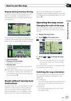
Chapter 04 How to use the map = For details, refer to Setting the current street name display on page 156. 9 Extension tab for the AV information bar Touching this tab opens the AV information bar and enables you to briefly view the current status on the AV source. Touching it again retracts the bar. a Shortcut to the AV operation screen The AV source currently selected is shown. Touching the indicator displays the AV operation screen of the current source directly. p If you connect your iPod to this navigation system, the artwork for the album that is playing appears. b Quick Access icon Displays the "Quick Access" menu. = For details, refer to Setting the "Quick Access" menu on page 28. c Map orientation indicator ! When "North up" is selected, is displayed. ! When "Heading up" is selected, is displayed. p The red arrow indicates north. d Current route* The route currently set is highlighted in color on the map. If a waypoint is set on the route, the route after the next waypoint is highlighted in another color. e Direction line* The direction towards your destination (next waypoint, or cursor) is indicated with a straight line. f Bluetooth connection icon This icon shows whether the device featuring Bluetooth technology is connected or not. You can select between display and non-display. = For details, refer to Displaying the Bluetooth connection icon on page 156. g Multi-Info window Each touch of [Multi-Info window] changes the display information. ! Distance to the destination (or distance to waypoint)* ! Estimated time of arrival at your destination or waypoint* The estimated time of arrival is an ideal value calculated based on the value set for "Average Speed" and the actual driving speed. The estimated time of arrival is only a reference value, and does not guarantee arrival at that time. ! Travel time to your destination or waypoint* h Current time Meaning of guidance flags Destination The checkered flag indicates your destination. Waypoint The blue flags indicate your waypoints. Guidance point The next guidance point (next turning point, etc.) is shown by a yellow flag. Enlarged map of the intersection When "Close Up View" in the "Map Settings" screen is "On", an enlarged map of the intersection appears. = For details, refer to Setting the auto-zoom display on page 154. 26 En
-
 1
1 -
2
-
3
-
4
-
5
-
6
-
7
-
8
-
9
-
10
-
11
-
12
-
13
-
14
-
15
-
16
-
17
-
18
-
19
-
20
-
 21
21 -
 22
22 -
 23
23 -
 24
24 -
 25
25 -
 26
26 -
 27
27 -
 28
28 -
 29
29 -
 30
30 -
 31
31 -
32
-
33
-
34
-
35
-
36
-
37
-
38
-
39
-
40
-
41
-
42
-
43
-
44
-
45
-
46
-
47
-
48
-
49
-
50
-
51
-
52
-
53
-
54
-
55
-
56
-
57
-
58
-
59
-
60
-
61
-
62
-
63
-
64
-
65
-
66
-
67
-
68
-
69
-
70
-
71
-
72
-
73
-
74
-
75
-
76
-
77
-
78
-
79
-
80
-
81
-
82
-
83
-
84
-
85
-
86
-
87
-
88
-
89
-
90
-
91
-
92
-
93
-
94
-
95
-
96
-
97
-
98
-
99
-
100
-
101
-
102
-
103
-
104
-
105
-
106
-
107
-
108
-
109
-
110
-
111
-
112
-
113
-
114
-
115
-
116
-
117
-
118
-
119
-
120
-
121
-
122
-
123
-
124
-
125
-
126
-
127
-
128
-
129
-
130
-
131
-
132
-
133
-
134
-
135
-
136
-
137
-
138
-
139
-
140
-
141
-
142
-
143
-
144
-
145
-
146
-
147
-
148
-
149
-
150
-
151
-
152
-
153
-
154
-
155
-
156
-
157
-
158
-
159
-
160
-
161
-
162
-
163
-
164
-
165
-
166
-
167
-
168
-
169
-
170
-
171
-
172
-
173
-
174
-
175
-
176
-
177
-
178
-
179
-
180
-
181
-
182
-
183
-
184
-
185
-
186
-
187
-
188
-
189
-
190
-
191
-
192
-
193
-
194
-
195
-
196
-
197
-
198
-
199
-
200
-
201
-
202
-
203
-
204
-
205
-
206
-
207
-
208
-
209
-
210
-
211
-
212
-
213
-
214
-
215
-
216
-
217
-
218
-
219
-
220
-
221
-
222
-
223
-
224
-
225
-
226
-
227
-
228
 |
 |
