Icom ID-52A Advanced Manual english - Page 104
GPS OPERATION ADVANCED, D-PRS data content
 |
View all Icom ID-52A manuals
Add to My Manuals
Save this manual to your list of manuals |
Page 104 highlights
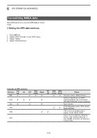
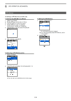
6 GPS OPERATION (ADVANCED) Transmitting D-PRS data TIP: D-PRS data content D-PRS data content are shown below� DPosition (Mobile) (e�g�) JA3YUA-A>API52,DSTAR*:/002338h3437�38N/13534�29E>090/002/A=000012ID-52 OP�SATOH qw e ru i !0 !1 !3 !4 o o DPosition (Base) (e�g�) JA3YUA-A>API52,DSTAR*:/002338h3437�38N/13534�29E-PHG5132OP�SATOH qw e ru i !0 !2 !4 o o DObject (e�g�) JA3YUA-A>API52,DSTAR*:;HAM FESTA*012345z3437�38N\13534�29Eh2021�11�01 am10-pm4 qw e r t yu i o !0 o !4 DItem (e�g�) JA3YUA-A>API52,DSTAR*:)REPEATER!3454�00N/13536�00ErPHG5132439�39MHzDV RPT JP3YHH A qw e r t y i o !0 o !2 !4 DWeather (e�g�) JA3YUA-A>API52,DSTAR*:/012345z3454�00N/13536�00E_220/004g005t077r000p000P000h50b09900 qw e ru i !0 !5 o o !6 !7 !8 !9 @0 @1 @2 qCall sign wSSID eUnproto Address rD-PRS Data type / Position with time stamp ! Position without time stamp ; Object ) Item tObject Name/Item Name yData Type * Live Object ! Live Item _ Killed Object/Killed Item uTime Stamp (UTC) h Hour Minute Second z Day Hour Minute iLatitude oSymbol !0Longitude !1Data Extension (Course/Speed) Course:0 ~ 360° Speed:0 ~ 999 knots !D2 ata Extension(PHG codes) PHG codes definitions First: Power Second: Height Third: Gain Fourth: Directivity 0 0 10 0 omni 1 1 20 1 45°NE 2 4 40 2 90°E 3 9 80 3 135°SE 4 16 160 4 180°S 5 6 7 8 25 36 49 64 320 640 1280 2560 5 6 7 8 225°SW 270°W 315°NW 360°N 9 81 5120 9 − (W) (feet) (dB) − !3Altitude −99999 ~ 999999 feet !4Comment !5Wind direction/Wind speed Wind direction:0 ~ 360° Wind speed: 0 ~ 999 mph !6Gust speed 0 ~ 999 mph !7Temperature −99 ~ 999ƒ !8Rainfall 0�00 ~ 9�99 inch !9Rainfall (24 Hours) 0�00 ~ 9�99 inch @0Rainfall (Midnight) 0�00 ~ 9�99 inch @1Humidity 1 ~ 99%, 00=100% @2Barometric pressure 0�0 ~ 9999�9 hPa 6-19
-
 1
1 -
2
-
3
-
4
-
5
-
6
-
7
-
8
-
9
-
10
-
11
-
12
-
13
-
14
-
15
-
16
-
17
-
18
-
19
-
20
-
21
-
22
-
23
-
24
-
25
-
26
-
27
-
28
-
29
-
30
-
31
-
32
-
33
-
34
-
35
-
36
-
37
-
38
-
39
-
40
-
41
-
42
-
43
-
44
-
45
-
46
-
47
-
48
-
49
-
50
-
51
-
52
-
53
-
54
-
55
-
56
-
57
-
58
-
59
-
60
-
61
-
62
-
63
-
64
-
65
-
66
-
67
-
68
-
69
-
70
-
71
-
72
-
73
-
74
-
75
-
76
-
77
-
78
-
79
-
80
-
81
-
82
-
83
-
84
-
85
-
86
-
87
-
88
-
89
-
90
-
91
-
92
-
93
-
94
-
95
-
96
-
97
-
98
-
 99
99 -
 100
100 -
 101
101 -
 102
102 -
 103
103 -
 104
104 -
 105
105 -
 106
106 -
 107
107 -
 108
108 -
 109
109 -
110
-
111
-
112
-
113
-
114
-
115
-
116
-
117
-
118
-
119
-
120
-
121
-
122
-
123
-
124
-
125
-
126
-
127
-
128
-
129
-
130
-
131
-
132
-
133
-
134
-
135
-
136
-
137
-
138
-
139
-
140
-
141
-
142
-
143
-
144
-
145
-
146
-
147
-
148
-
149
-
150
-
151
-
152
-
153
-
154
-
155
-
156
-
157
-
158
-
159
-
160
-
161
-
162
-
163
-
164
-
165
-
166
-
167
-
168
-
169
-
170
-
171
-
172
-
173
-
174
-
175
-
176
-
177
-
178
-
179
-
180
-
181
-
182
-
183
-
184
-
185
-
186
-
187
-
188
-
189
-
190
-
191
-
192
-
193
-
194
-
195
-
196
-
197
-
198
-
199
-
200
-
201
-
202
-
203
-
204
-
205
-
206
-
207
-
208
-
209
-
210
-
211
-
212
-
213
-
214
-
215
-
216
-
217
-
218
-
219
-
220
-
221
-
222
-
223
-
224
-
225
-
226
-
227
-
228
-
229
-
230
-
231
-
232
-
233
-
234
-
235
-
236
-
237
-
238
-
239
-
240
-
241
-
242
-
243
-
244
-
245
-
246
-
247
-
248
-
249
-
250
-
251
-
252
-
253
-
254
-
255
-
256
-
257
-
258
-
259
-
260
-
261
-
262
-
263
 |
 |
