Garmin eTrex Summit Owner's Manual (Software Version 3.00 and above) &nbs - Page 29
Map
 |
View all Garmin eTrex Summit manuals
Add to My Manuals
Save this manual to your list of manuals |
Page 29 highlights
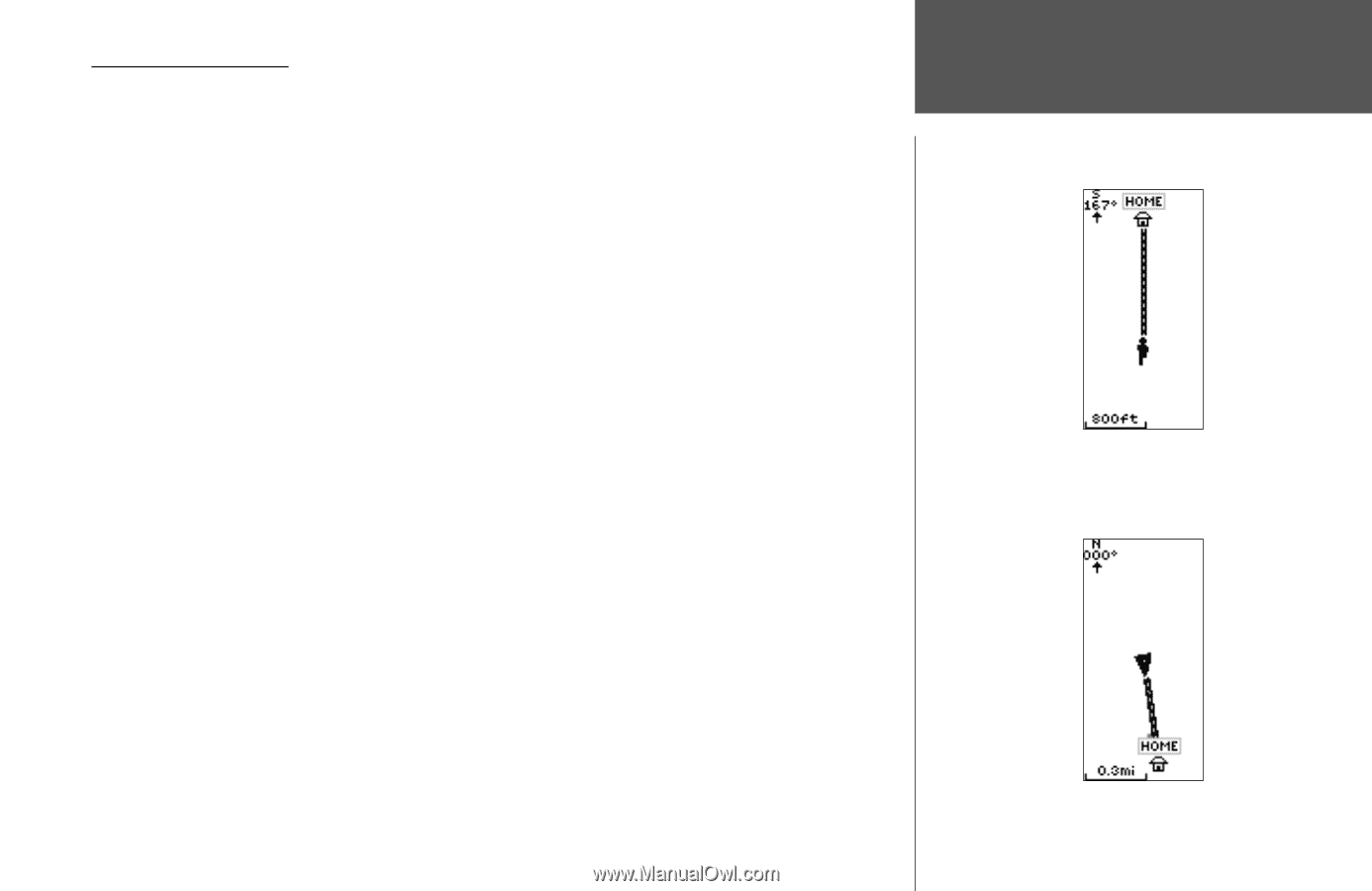
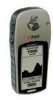
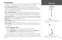
Map Page Options In addition to the Map Page basics described on page 4, there is a 'MAP OPTIONS' feature which allows you to customize the Map Page. The following options are available: • Orient Map Ahead/Northwards: When 'AHEAD' is selected, the top of the map is oriented in the direction you are currently moving. When 'NORTHWARDS' is selected, the map is always oriented to the north, and your current position is indicated by a direction arrow (see the illustrations on this page). • Show Course/Bearing Line: When using the GOTO function (see page 11), use this option to show a Course Line or Bearing Line to your destination. A Course Line is fixed from your starting location, while a Bearing Line changes based on your current location. • Auto Zoom On/Off: When 'AUTO ZOOM' is turned on, the map automatically adjusts its scale to display your entire navigating route. When it's turned off, you must press the UP or DOWN buttons to select the appropriate map scale. • Hide Waypoints: 'HIDE WAYPOINTS' will keep waypoint symbols and names from being displayed on the Map Page. • Stop Navigation: 'STOP NAVIGATION' stops any active navigation (navigation means there is a destination waypoint or active route). This option cannot be selected if there is no active navigation. To select a Map Page option: 1. Press the ENTER button on the MAP Page. The Map Options Menu appears. 2. Press the UP or DOWN button to highlight the desired option, then press ENTER. Once you press ENTER, the change is made and the Options Menu disappears. Notice the little grey "person" on the Map Page. The person stands still when you are not moving and moves when you move. A blinking "?" means the eTrex Summit has lost satellite reception. You should reposition the eTrex Summit or move to a place that has a clear view of the sky. Map Page Options Selecting 'Orient Map Ahead' from the Map Page options orients the map to the direction you are moving. When you select 'Orient Map Northwards' the figure icon is replaced by a 'direction' triangle. 15
-
 1
1 -
2
-
3
-
4
-
5
-
6
-
7
-
8
-
9
-
10
-
11
-
12
-
13
-
14
-
15
-
16
-
17
-
18
-
19
-
20
-
21
-
22
-
23
-
 24
24 -
 25
25 -
 26
26 -
 27
27 -
 28
28 -
 29
29 -
 30
30 -
 31
31 -
 32
32 -
 33
33 -
 34
34 -
35
-
36
-
37
-
38
-
39
-
40
-
41
-
42
-
43
-
44
-
45
-
46
-
47
-
48
-
49
-
50
-
51
-
52
-
53
-
54
-
55
-
56
-
57
-
58
-
59
-
60
-
61
-
62
-
63
-
64
-
65
-
66
-
67
-
68
-
69
-
70
-
71
-
72
-
73
-
74
-
75
-
76
-
77
-
78
-
79
-
80
 |
 |