Garmin eTrex Summit Owner's Manual (Software Version 3.00 and above) &nbs - Page 63
Heading
 |
View all Garmin eTrex Summit manuals
Add to My Manuals
Save this manual to your list of manuals |
Page 63 highlights
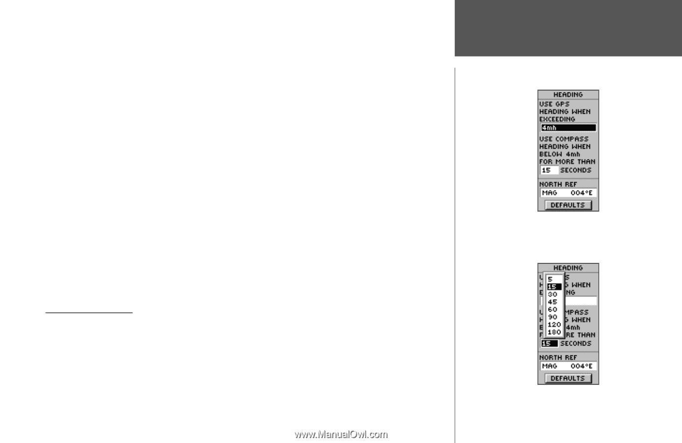
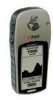
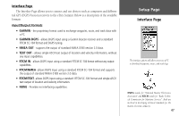
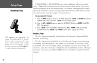
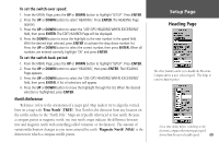
To set the switch-over speed: 1. From the MENU Page, press the UP or DOWN button to highlight 'SETUP'. Press ENTER. 2. Press the UP or DOWN button to select 'HEADING'. Press ENTER. The HEADING Page appears. 3. Press the UP or DOWN button to select the 'USE GPS HEADING WHEN EXCEEDING' field, then press ENTER. The EDIT NUMBER Page will be displayed. 4. Press the DOWN button to move the highlight to the next number in the speed field. With the desired digit selected, press ENTER to activate the drop down number list. Press the UP or DOWN button to select the correct number, then press ENTER. When all numbers are entered correctly, highlight 'OK' and press ENTER. To set the switch-back period: 1. From the MENU Page, press the UP or DOWN button to highlight 'SETUP'. Press ENTER. 2. Press the UP or DOWN button to select 'HEADING', then press ENTER. The HEADING Page appears. 3. Press the UP or DOWN button to select the 'USE GPS HEADING WHEN EXCEEDING' field, then press ENTER. A list of selections will appear. 4. Press the UP or DOWN button to move the highlight through the list. When the desired selection is highlighted, press ENTER. North Reference 'Reference' refers to the orientation of a map's grid. Map makers try to align the vertical lines on a map with 'True North' (TRUE). True North is the direction from any location on the earth's surface to the "North Pole". Maps are typically referenced to true north. Because a compass points to magnetic north, not true north, maps indicate the difference between true and magnetic north with something called 'variation' or 'declination'. The amount of variation/declination changes as you move around the earth. 'Magnetic North' (MAG) is the direction in which a compass needle points. Setup Page Heading Page The eTrex Summit can be set to disable the Electronic Compass above a user selected speed. This helps to conserve battery power. Set a time delay before switching to the electronic compass when moving at a speed slower than the user-selectable speed. 49
-
 1
1 -
2
-
3
-
4
-
5
-
6
-
7
-
8
-
9
-
10
-
11
-
12
-
13
-
14
-
15
-
16
-
17
-
18
-
19
-
20
-
21
-
22
-
23
-
24
-
25
-
26
-
27
-
28
-
29
-
30
-
31
-
32
-
33
-
34
-
35
-
36
-
37
-
38
-
39
-
40
-
41
-
42
-
43
-
44
-
45
-
46
-
47
-
48
-
49
-
50
-
51
-
52
-
53
-
54
-
55
-
56
-
57
-
 58
58 -
 59
59 -
 60
60 -
 61
61 -
 62
62 -
 63
63 -
 64
64 -
 65
65 -
 66
66 -
 67
67 -
 68
68 -
69
-
70
-
71
-
72
-
73
-
74
-
75
-
76
-
77
-
78
-
79
-
80
 |
 |