Garmin GPS III Plus Owner's Manual - Page 109

Index

Page 109 highlights

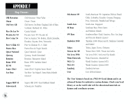
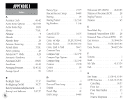
Options 56-57 GPS Overview 4 H Heading Selection 76 Highlight 2 Highway Display 12,24,43 Highway Page 12,24,43 Highway Page Options 44 Highway Exits 35,52 "How To" Index viii I Initialization 4-6,27,29 Installation, antenna 85 Installation, wiring 84 IN Zoom Key 2 Interface Formats 73,81,84 Interface Settings 73.81.84 Interstate Highway Exits 35 K Keypad Usage 2 L Lakes, on Map 39-40 Lat/Long Grid 39-40 Leg Distance 91 Leg Fuel 91 Leg Time 91 Loran TD 82-83 M Main Menu 13,67 Main Page Sequence 7,18 Manual Tune(DGPS 85 Map Datum List 88-90 Map Datum Selection 73,80 Map Detail 39 Map Orientation 10,19,39-40 Map Page 10,19,33-34 Map Page Options 37-40 Map Scale 10,19,33 Map Setup 39-40 MapSource Data . . . . . 37,39,42,84,91 Mark Position Page 14,22,45 Marking a Position . . . . . .14,22,45-46 Maximum Speed 91 Measuring Between Waypoints . . . . 38 Menu Key 2 Messages 86-87 MGRS Coordinates 82 APPENDIX I Index MOB Function 53,55 Mounting 82 N Navigation Basics 91-92 Navigation Units 76 Nearest Cities 15,38-41,51-52 Nearest Exits 15,38-41,51-52 Nearest Geo Points . . . 15,38-41,51-52 Nearest Location Options 52 Nearest Locations List 51,64 Nearest To Pointer 38-39 Nearest Waypoints . . . 15,38-41,51-52 NMEA Output Formats 84 O Off Course 79,91 Offset, local time 78 Odometer 91 Orientation, map 10,19 Orientation, screen 1,75 OUT Zoom Key 2 Output Setup 81 99

  • 1
  • 2
  • 3
  • 4
  • 5
  • 6
  • 7
  • 8
  • 9
  • 10
  • 11
  • 12
  • 13
  • 14
  • 15
  • 16
  • 17
  • 18
  • 19
  • 20
  • 21
  • 22
  • 23
  • 24
  • 25
  • 26
  • 27
  • 28
  • 29
  • 30
  • 31
  • 32
  • 33
  • 34
  • 35
  • 36
  • 37
  • 38
  • 39
  • 40
  • 41
  • 42
  • 43
  • 44
  • 45
  • 46
  • 47
  • 48
  • 49
  • 50
  • 51
  • 52
  • 53
  • 54
  • 55
  • 56
  • 57
  • 58
  • 59
  • 60
  • 61
  • 62
  • 63
  • 64
  • 65
  • 66
  • 67
  • 68
  • 69
  • 70
  • 71
  • 72
  • 73
  • 74
  • 75
  • 76
  • 77
  • 78
  • 79
  • 80
  • 81
  • 82
  • 83
  • 84
  • 85
  • 86
  • 87
  • 88
  • 89
  • 90
  • 91
  • 92
  • 93
  • 94
  • 95
  • 96
  • 97
  • 98
  • 99
  • 100
  • 101
  • 102
  • 103
  • 104
  • 105
  • 106
  • 107
  • 108
  • 109
  • 110
  • 111
  • 112
  • 113
  • 114

Index
APPENDIX I
99
Options
. . . . . . . . . . . . . . . .56-57
GPS Overview
. . . . . . . . . . . . . . . . . 4
H
Heading Selection
. . . . . . . . . . . . . 76
Highlight . . . . . . . . . . . . . . . . . . . . .2
Highway Display
. . . . . . . . . 12,24,43
Highway Page . . . . . . . . . . . . 12,24,43
Highway Page Options . . . . . . . . . . 44
Highway Exits
. . . . . . . . . . . . . .35,52
"How To" Index . . . . . . . . . . . . . . .viii
I
Initialization . . . . . . . . . . . . .4-6,27,29
Installation, antenna . . . . . . . . . . . . 85
Installation, wiring . . . . . . . . . . . . . 84
IN Zoom Key . . . . . . . . . . . . . . . . . .2
Interface Formats . . . . . . . . .73,81,84
Interface Settings . . . . . . . . .73.81.84
Interstate Highway Exits
. . . . . . . . 35
K
Keypad Usage . . . . . . . . . . . . . . . . . . 2
L
Lakes, on Map . . . . . . . . . . . . . .39-40
Lat/Long Grid . . . . . . . . . . . . . . .39-40
Leg Distance . . . . . . . . . . . . . . . . . . 91
Leg Fuel . . . . . . . . . . . . . . . . . . . . .91
Leg Time
. . . . . . . . . . . . . . . . . . . . 91
Loran TD . . . . . . . . . . . . . . . . . .82-83
M
Main Menu . . . . . . . . . . . . . . . . .13,67
Main Page Sequence . . . . . . . . . . .7,18
Manual Tune(DGPS) . . . . . . . . . . . . 85
Map Datum List . . . . . . . . . . . . .88-90
Map Datum Selection . . . . . . . . .73,80
Map Detail . . . . . . . . . . . . . . . . . . .39
Map Orientation . . . . . . . .10,19,39-40
Map Page . . . . . . . . . . . . .10,19,33-34
Map Page Options . . . . . . . . . . .37-40
Map Scale . . . . . . . . . . . . . . . 10,19,33
Map Setup . . . . . . . . . . . . . . . . .39-40
MapSource Data . . . . . 37,39,42,84,91
Mark Position Page . . . . . . . . 14,22,45
Marking a Position . . . . . .14,22,45-46
Maximum Speed
. . . . . . . . . . . . . . 91
Measuring Between Waypoints . . . . 38
Menu Key . . . . . . . . . . . . . . . . . . . . . 2
Messages
. . . . . . . . . . . . . . . . . .86-87
MGRS Coordinates . . . . . . . . . . . . . 82
MOB Function . . . . . . . . . . . . . .53,55
Mounting
. . . . . . . . . . . . . . . . . . . 82
N
Navigation Basics . . . . . . . . . . . .91-92
Navigation Units
. . . . . . . . . . . . . . 76
Nearest Cities . . . . . . .15,38-41,51-52
Nearest Exits
. . . . . . . 15,38-41,51-52
Nearest Geo Points . . . 15,38-41,51-52
Nearest Location Options . . . . . . . . 52
Nearest Locations List
. . . . . . . .51,64
Nearest To Pointer . . . . . . . . . . .38-39
Nearest Waypoints . . .15,38-41,51-52
NMEA Output Formats . . . . . . . . .84
O
Off Course . . . . . . . . . . . . . . . . .79,91
Offset, local time
. . . . . . . . . . . . . . 78
Odometer . . . . . . . . . . . . . . . . . . . . 91
Orientation, map . . . . . . . . . . . .10,19
Orientation, screen . . . . . . . . . . . .1,75
OUT Zoom Key . . . . . . . . . . . . . . . .2
Output Setup . . . . . . . . . . . . . . . . .81