Garmin GPS III Plus Owner's Manual - Page 62
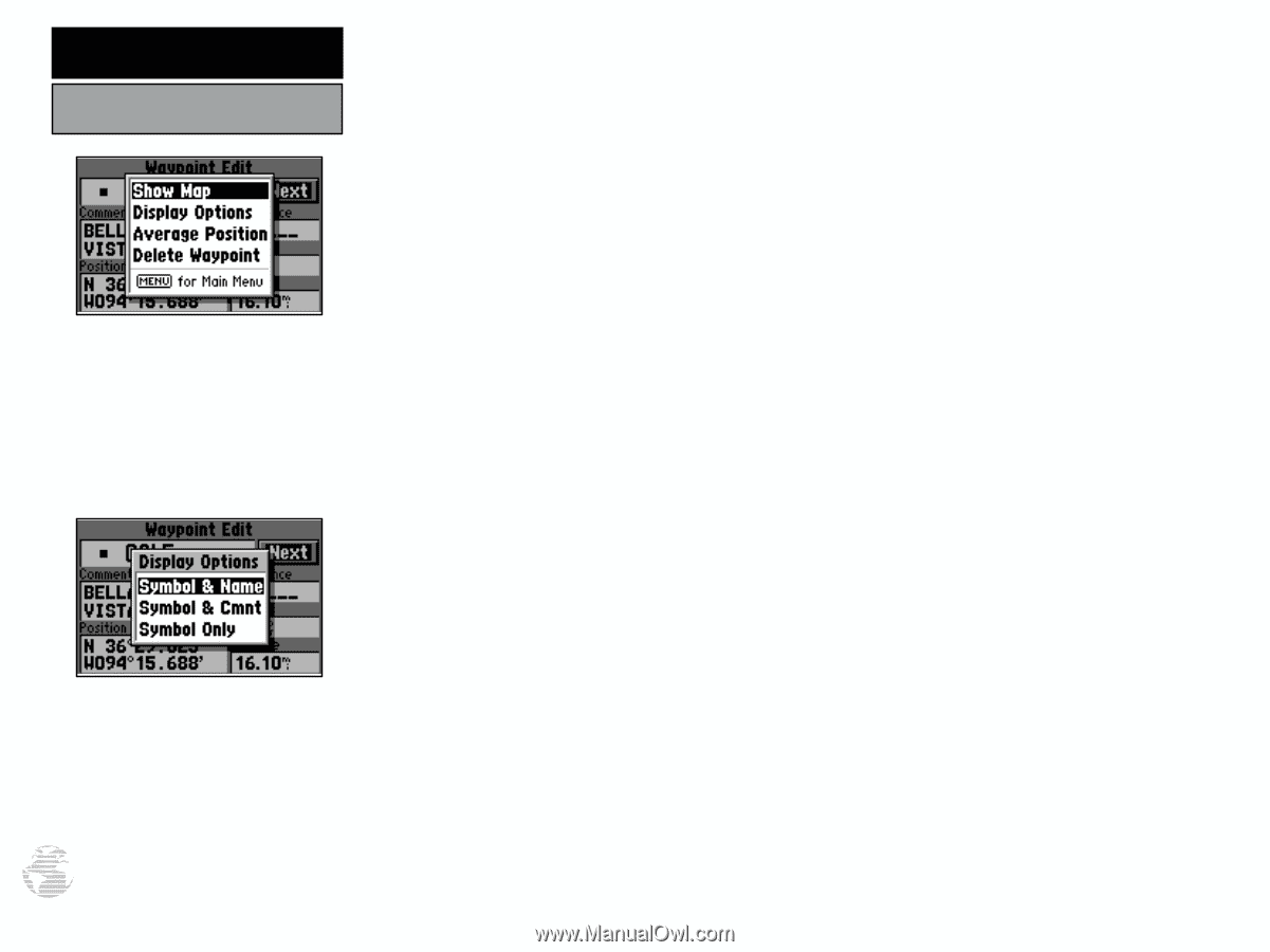
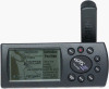
Comment Cmnt, or Symbol Only.
 |
UPC - 753759015817
View all Garmin GPS III Plus manuals
Add to My Manuals
Save this manual to your list of manuals |
Page 62 highlights
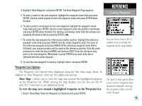
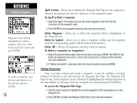
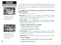
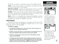
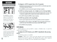
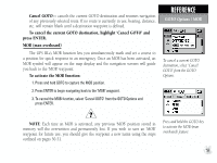
REFERENCE Waypoint Edit Options 'Show Map' allows you to view the area around the waypoint's position. 'Display Options' lets you determine what waypoint information will appear on the map display. 52 The Waypoint Edit Page also features an options page that allows you to delete the waypoint, view the map area around the waypoint position, define how the waypoint will appear on the map display or average the waypoint position to improve accuracy. To display the Waypoint Edit Options, press MENU (with the Waypoint Edit Page displayed). The following options are available: Show Map- allows you to view the map area surrounding the selected waypoint's position. While viewing the map display, you can also use the IN and OUT zoom keys to see additional detail. Display Options- lets you designate how the selected waypoint will appear on the map display. Options are provided to show Symbol & Name, Symbol & Comment (Cmnt), or Symbol Only. To change the display options for a waypoint: 1. Highlight 'Display Options' and press ENTER. 2. Highlight the desired option and press ENTER. Average Position- allows you to average position samples over time to update the waypoint's position with a more accurate position reading. (See page 31 for more information on averaging.) Delete Waypoint- allows you to remove the selected waypoint from memory. To delete a waypoint: 1. Highlight 'Delete Waypoint' and press ENTER. A confirmation screen is displayed. 2. ENTER to delete (or QUIT to cancel).
-
 1
1 -
2
-
3
-
4
-
5
-
6
-
7
-
8
-
9
-
10
-
11
-
12
-
13
-
14
-
15
-
16
-
17
-
18
-
19
-
20
-
21
-
22
-
23
-
24
-
25
-
26
-
27
-
28
-
29
-
30
-
31
-
32
-
33
-
34
-
35
-
36
-
37
-
38
-
39
-
40
-
41
-
42
-
43
-
44
-
45
-
46
-
47
-
48
-
49
-
50
-
51
-
52
-
53
-
54
-
55
-
56
-
 57
57 -
 58
58 -
 59
59 -
 60
60 -
 61
61 -
 62
62 -
 63
63 -
 64
64 -
 65
65 -
 66
66 -
 67
67 -
68
-
69
-
70
-
71
-
72
-
73
-
74
-
75
-
76
-
77
-
78
-
79
-
80
-
81
-
82
-
83
-
84
-
85
-
86
-
87
-
88
-
89
-
90
-
91
-
92
-
93
-
94
-
95
-
96
-
97
-
98
-
99
-
100
-
101
-
102
-
103
-
104
-
105
-
106
-
107
-
108
-
109
-
110
-
111
-
112
-
113
-
114
 |
 |