Garmin GPS III Plus Owner's Manual - Page 92
Setup Menu: Position
 |
UPC - 753759015817
View all Garmin GPS III Plus manuals
Add to My Manuals
Save this manual to your list of manuals |
Page 92 highlights
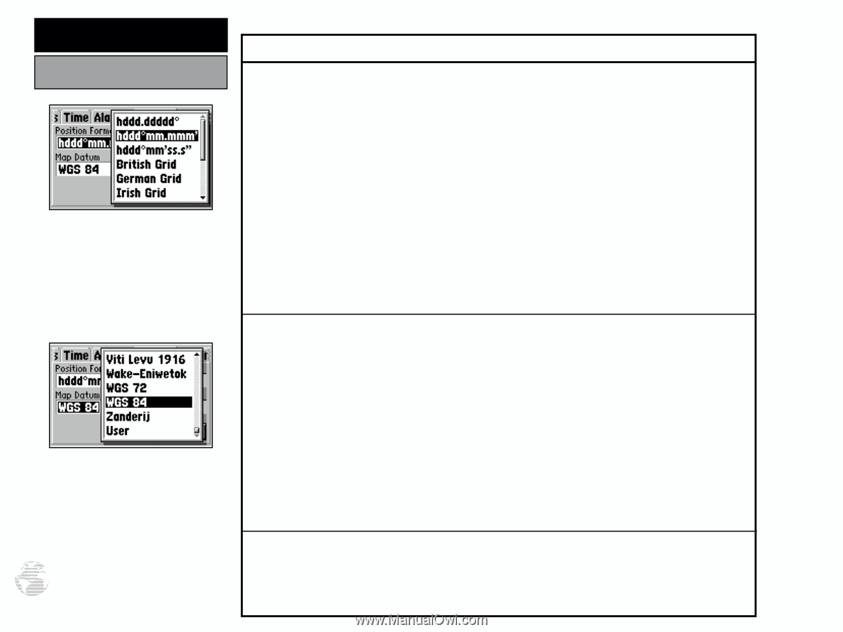
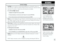
REFERENCE Setup Menu: Position Only the latitude/longitude, UTM/UPS and Maidenhead settings apply worldwide. The additional grid settings are only valid for a specific region. Datums are used to describe geographic positions for surveying, mapping, and navigation and are not actual maps built in the unit. Use WGS 84 unless your chart specifies otherwise. 82 Position Settings Position Format is used to change the coordinate system in which a given position reading is displayed. The default format is latitude and longitude in degrees and minutes (hddd°mm.mmm'). The following additional formats are available: • hddd.ddddd° - latitude/longitude in decimal degrees only • hddd°mm'ss.s" - latitude/longitude in degrees, minutes, seconds • UTM/UPS - Universal Transverse Mercator / Universal Polar Stereographic grids • MGRS - Military Grid Reference System • British Grid • German Grid • Irish Grid • Maidenhead • New Zealand • Swedish Grid • Swiss Grid • Taiwan Grid • User UTM Grid • Loran TD (See following page.) Map Datum allows you to select the datum reference used to determine where a given position is. The default setting is 'WGS 84'. Although over 100 datums are available (as listed on page 92-94), you should only change the datum if you are using a map or chart that specifies a different datum. Make sure the settings under the 'Position' tab of the III+ match that of the map or chart. This information should be displayed somewhere on the map or chart. If the information is not present, contact the map or chart maker to determine what position format, datum, heading and units of measure are being used for the map or chart. WARNING: Selecting the wrong map datum can result in substantial position errors. When in doubt, seek assistance or use the default WGS 84 datum for best overall performance. To change the position format and/or map datum: 1. Highlight the 'Position Format' or 'Map Datum' field and press ENTER. 2. Select the desired setting (using the rocker keypad) and press ENTER.
-
 1
1 -
2
-
3
-
4
-
5
-
6
-
7
-
8
-
9
-
10
-
11
-
12
-
13
-
14
-
15
-
16
-
17
-
18
-
19
-
20
-
21
-
22
-
23
-
24
-
25
-
26
-
27
-
28
-
29
-
30
-
31
-
32
-
33
-
34
-
35
-
36
-
37
-
38
-
39
-
40
-
41
-
42
-
43
-
44
-
45
-
46
-
47
-
48
-
49
-
50
-
51
-
52
-
53
-
54
-
55
-
56
-
57
-
58
-
59
-
60
-
61
-
62
-
63
-
64
-
65
-
66
-
67
-
68
-
69
-
70
-
71
-
72
-
73
-
74
-
75
-
76
-
77
-
78
-
79
-
80
-
81
-
82
-
83
-
84
-
85
-
86
-
 87
87 -
 88
88 -
 89
89 -
 90
90 -
 91
91 -
 92
92 -
 93
93 -
 94
94 -
 95
95 -
 96
96 -
 97
97 -
98
-
99
-
100
-
101
-
102
-
103
-
104
-
105
-
106
-
107
-
108
-
109
-
110
-
111
-
112
-
113
-
114
 |
 |