Garmin GPS III Plus Owner's Manual - Page 47
Map Options - mapsource
 |
UPC - 753759015817
View all Garmin GPS III Plus manuals
Add to My Manuals
Save this manual to your list of manuals |
Page 47 highlights
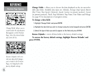
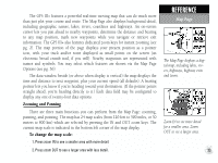
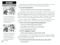
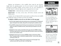
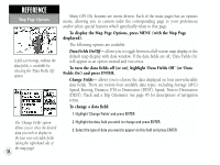
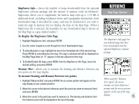
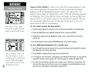
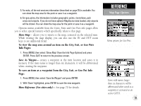
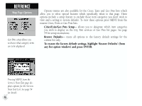
MapSource Info- shows the number of maps downloaded from the optional MapSource software package and the amount of memory used (in kilobytes). MapSource allows you to supplement the built-in map with up to 1.44 MB of additional detail, including residential streets and topographic information. Each downloaded map is described by name, and may be deselected if you wish to retain the map in memory, but not display the data on the Map Page. (When a MapSource file is selected, the boundary for any downloaded map is shown on the Map Page as a gray shaded outline.) To display the MapSource Info Page: 1. Highlight 'MapSource Info' and press ENTER. 2. Use the rocker keypad to scroll through the list of downloaded maps. 3. To select/deselect a map, highlight the box to the immediate left of the desired map. Press ENTER to select/deselect the map. The map is selected and will be displayed on the Map Page when an "X" appears in the box adjacent to that map. 4. To Enable/Disable All maps, press MENU from the MapSource Info Page, select the desired setting, and press ENTER. Measure Dist- allows you to measure the bearing and distance between any two points on the map display. To measure bearing and distance between two points: 1. Highlight 'Measure Dist' and press ENTER. An on-screen pointer will appear on the map display at your present position. 2. Move the cursor to the desired reference point (the point you want to measure from) and press ENTER. 3. Move the cursor to the point you want to measure to. The bearing and distance from the reference point will be displayed at the top of the page. REFERENCE Map Page Options The MapSource Info page lists any detailed maps that have been downloaded from the optional MapSource software package. When using the 'Measure Dist' option, the arrow includes an 'Enter Reference' prompt and the arrow position appears at the top of the map display. 37
-
 1
1 -
2
-
3
-
4
-
5
-
6
-
7
-
8
-
9
-
10
-
11
-
12
-
13
-
14
-
15
-
16
-
17
-
18
-
19
-
20
-
21
-
22
-
23
-
24
-
25
-
26
-
27
-
28
-
29
-
30
-
31
-
32
-
33
-
34
-
35
-
36
-
37
-
38
-
39
-
40
-
41
-
 42
42 -
 43
43 -
 44
44 -
 45
45 -
 46
46 -
 47
47 -
 48
48 -
 49
49 -
 50
50 -
 51
51 -
 52
52 -
53
-
54
-
55
-
56
-
57
-
58
-
59
-
60
-
61
-
62
-
63
-
64
-
65
-
66
-
67
-
68
-
69
-
70
-
71
-
72
-
73
-
74
-
75
-
76
-
77
-
78
-
79
-
80
-
81
-
82
-
83
-
84
-
85
-
86
-
87
-
88
-
89
-
90
-
91
-
92
-
93
-
94
-
95
-
96
-
97
-
98
-
99
-
100
-
101
-
102
-
103
-
104
-
105
-
106
-
107
-
108
-
109
-
110
-
111
-
112
-
113
-
114
 |
 |
