Magellan Meridian Platinum User Manual - Page 38
Setting Up Map Data Fields, Turning Map Info On/Off, Selecting the Map Information, Two Data Fields
 |
UPC - 763357103267
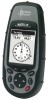
View all Magellan Meridian Platinum manuals
Add to My Manuals
Save this manual to your list of manuals |
Page 38 highlights
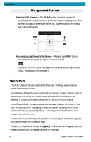
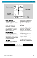
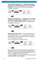
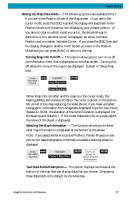
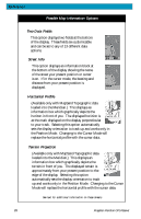
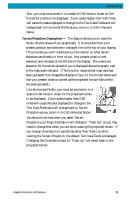
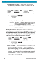
Reference Setting Up Map Data Fields - The following options are available ONLY if you are in the Position Mode of the Map screen. If you are in the cursor mode, press the [ESC] key and the display will snap back to the Position Mode with the arrow icon displaying your present postion. (If you are not clear on which mode you are in, the simpliest way to determine it is to see what cursor is displayed; an arrow indicates Position and a crosshair indicates Cursor. If you press the [ESC] key and the display changes to another NAV Screen you were in the Position Mode and you can press [NAV] to return to the map. Turning Map Info On/Off - This option allows you to turn on or off the information field that is displayed on the Map screen. Turning this off allows for more of the map to be displayed. Default is "Show Map Info". From the MAP Screen MENU Highlight Hide Map Info or Show Map Info ENTER When Map Info is hidden and the map is in the cursor mode, the bearing (BRG) and distance (DIS) to the cursor is shown in the bottom left corner of the map replacing the scale. (Note: if you have uploaded topographic information from Magellan's MapSend Topo for the United States CD-ROM, the elevation at the cursor's location is displayed, not the bearing and distance.) If the cursor happens to be on a map object, the name of the object is displayed. Selecting the Map Information - This function allows you to select what map information is displayed at the bottom of the screen. Note: If you select either Horizontal Profile or Terrain Projection and you do not have topographic information loaded a warning screen is displayed. From MENU the MAP Screen Highlight Select Map Info ENTER Use U/D arrows to select desired information ENTER Two Data Fields Description - This option displays two boxes at the bottom of the map that can display data that you choose. Displaying these data fields is the default for the Meridian. Magellan Meridian GPS Receiver 27
-
 1
1 -
2
-
3
-
4
-
5
-
6
-
7
-
8
-
9
-
10
-
11
-
12
-
13
-
14
-
15
-
16
-
17
-
18
-
19
-
20
-
21
-
22
-
23
-
24
-
25
-
26
-
27
-
28
-
29
-
30
-
31
-
32
-
 33
33 -
 34
34 -
 35
35 -
 36
36 -
 37
37 -
 38
38 -
 39
39 -
 40
40 -
 41
41 -
 42
42 -
 43
43 -
44
-
45
-
46
-
47
-
48
-
49
-
50
-
51
-
52
-
53
-
54
-
55
-
56
-
57
-
58
-
59
-
60
-
61
-
62
-
63
-
64
-
65
-
66
-
67
-
68
-
69
-
70
-
71
-
72
-
73
-
74
-
75
-
76
-
77
-
78
-
79
-
80
-
81
-
82
-
83
-
84
-
85
-
86
-
87
-
88
-
89
-
90
-
91
-
92
-
93
-
94
-
95
-
96
-
97
-
98
-
99
-
100
-
101
-
102
-
103
-
104
-
105
 |
 |
