Magellan Meridian Platinum User Manual - Page 41
Available Data Options, Bearing, Distance, Speed, Heading, Elevation
 |
UPC - 763357103267
View all Magellan Meridian Platinum manuals
Add to My Manuals
Save this manual to your list of manuals |
Page 41 highlights
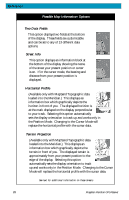
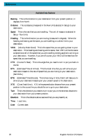
Reference Available Data Options Bearing This is the direction to your destination from your present position, in degrees, from North. Distance This is distance (measured in the Nav Units selected in Setup) to your destination. Speed This is the rate that you are travelling. The unit of measure is selected in Setup - Nav Units. Heading This is the direction you are moving (measured in degrees). When the heading and bearing are the same, you are travelling on a direct line to your destination. VMG (Velocity Made Good). This is the speed that you are getting closer to your destination. If the heading and bearing are the same, then VMG will be the same as Speed since all of the speed that you are travelling is being applied to arriving to your destination. However, if you are off course, your VMG will be less than the speed that you are travelling. CTS (Course To Steer). This is the angle that you need to turn to put you back on course. ETA (Estimated Time of Arrival). This the local time that you will arrive at your destination based on the rate of speed that you are moving to your destination. (See VMG.) ETE (Estimated Time Enroute). This is how long, in time, that it will take you to arrive at your destination based upon your present speed to the destination. XTE (Cross Track Error). XTE is the perpendicular distance from your present position to the course line you should be on to go to your destination. Turn This is the direction you need to turn to put you on the shortest distance to your destination from your present position. Elevation This is the distance above sea level that you are presently at. Time Local time. Date Current date. 30 Magellan Meridian GPS Receiver
-
 1
1 -
2
-
3
-
4
-
5
-
6
-
7
-
8
-
9
-
10
-
11
-
12
-
13
-
14
-
15
-
16
-
17
-
18
-
19
-
20
-
21
-
22
-
23
-
24
-
25
-
26
-
27
-
28
-
29
-
30
-
31
-
32
-
33
-
34
-
35
-
 36
36 -
 37
37 -
 38
38 -
 39
39 -
 40
40 -
 41
41 -
 42
42 -
 43
43 -
 44
44 -
 45
45 -
 46
46 -
47
-
48
-
49
-
50
-
51
-
52
-
53
-
54
-
55
-
56
-
57
-
58
-
59
-
60
-
61
-
62
-
63
-
64
-
65
-
66
-
67
-
68
-
69
-
70
-
71
-
72
-
73
-
74
-
75
-
76
-
77
-
78
-
79
-
80
-
81
-
82
-
83
-
84
-
85
-
86
-
87
-
88
-
89
-
90
-
91
-
92
-
93
-
94
-
95
-
96
-
97
-
98
-
99
-
100
-
101
-
102
-
103
-
104
-
105
 |
 |
