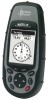
Magellan Meridian Platinum User Manual - Page 9

Routes, Using Vertical Profile, Setup - gps receiver

Page 9 highlights

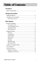
Routes 51 Creating a GOTO Route 51 Creating a Backtrack Route 51 Creating a Multileg Route 52 Activating/Deactivating a Route 53 Viewing a Route 54 Editing a Route 54 Inserting a Leg 54 Deleting a Leg 55 Replacing a Leg 55 Appending a Leg 55 Appending a Newly Created Waypoint to a Route 55 Reversing a Route 56 Deleting a Route 56 Viewing a Route on the Map Screen 56 Creating a Route using Track History 56 Using Vertical Profile 57 Selecting Vertical Profile 57 Track History Description 58 Highlighted Road Vertical Profile Description 58 Route Vertical Profile Description 58 Path Check Description 58 Setup ...59 Initializing the Meridian 59 Turning the NAV Screens On/Off 59 Selecting the Coordinate System 60 Selecting a Map Datum 60 Selecting the Elevation Mode 61 Selecting the Time Format 61 Selecting NAV Units 61 Selecting the North Reference 62 Selecting Daylight Savings 62 Power Off Timer 63 Setting the Backlight Timer 63 Turning the Beeper On/Off 64 Selecting NMEA Message 64 Selecting the Baud Rate 64 iv Magellan Meridian GPS Receiver

  • 1
  • 2
  • 3
  • 4
  • 5
  • 6
  • 7
  • 8
  • 9
  • 10
  • 11
  • 12
  • 13
  • 14
  • 15
  • 16
  • 17
  • 18
  • 19
  • 20
  • 21
  • 22
  • 23
  • 24
  • 25
  • 26
  • 27
  • 28
  • 29
  • 30
  • 31
  • 32
  • 33
  • 34
  • 35
  • 36
  • 37
  • 38
  • 39
  • 40
  • 41
  • 42
  • 43
  • 44
  • 45
  • 46
  • 47
  • 48
  • 49
  • 50
  • 51
  • 52
  • 53
  • 54
  • 55
  • 56
  • 57
  • 58
  • 59
  • 60
  • 61
  • 62
  • 63
  • 64
  • 65
  • 66
  • 67
  • 68
  • 69
  • 70
  • 71
  • 72
  • 73
  • 74
  • 75
  • 76
  • 77
  • 78
  • 79
  • 80
  • 81
  • 82
  • 83
  • 84
  • 85
  • 86
  • 87
  • 88
  • 89
  • 90
  • 91
  • 92
  • 93
  • 94
  • 95
  • 96
  • 97
  • 98
  • 99
  • 100
  • 101
  • 102
  • 103
  • 104
  • 105

iv
Magellan Meridian GPS Receiver
Routes
...................................................................................................
51
Creating a GOTO Route
.............................................................................
51
Creating a Backtrack Route
..........................................................................
51
Creating a Multileg Route
............................................................................
52
Activating/Deactivating a Route
..................................................................
53
Viewing a Route
..........................................................................................
54
Editing a Route
............................................................................................
54
Inserting a Leg
.........................................................................................
54
Deleting a Leg
.........................................................................................
55
Replacing a Leg
........................................................................................
55
Appending a Leg
......................................................................................
55
Appending a Newly Created Waypoint to a Route
.......................................
55
Reversing a Route
........................................................................................
56
Deleting a Route
..........................................................................................
56
Viewing a Route on the Map Screen
............................................................
56
Creating a Route using Track History
..........................................................
56
Using Vertical Profile
............................................................................
57
Selecting Vertical Profile
...............................................................................
57
Track History Description
...........................................................................
58
Highlighted Road Vertical Profile Description
.............................................
58
Route Vertical Profile Description
................................................................
58
Path Check Description
...............................................................................
58
Setup
....................................................................................................
59
Initializing the Meridian
..............................................................................
59
Turning the NAV Screens On/Off
...............................................................
59
Selecting the Coordinate System
..................................................................
60
Selecting a Map Datum
...............................................................................
60
Selecting the Elevation Mode
.......................................................................
61
Selecting the Time Format
...........................................................................
61
Selecting NAV Units
....................................................................................
61
Selecting the North Reference
......................................................................
62
Selecting Daylight Savings
...........................................................................
62
Power Off Timer
..........................................................................................
63
Setting the Backlight Timer
.........................................................................
63
Turning the Beeper On/Off
.........................................................................
64
Selecting NMEA Message
............................................................................
64
Selecting the Baud Rate
...............................................................................
64