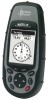
Magellan Meridian Platinum User Manual - Page 8

Position Screen, Road Screen, Data Screen, Speed Screen, Satellite Status Screen, Waypoints / - manual

Page 8 highlights

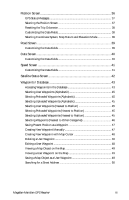
Position Screen 36 GPS Status Messages 37 Selecting the Position Screen 37 Resetting the Trip Odometer 38 Customizing the Data Fields 38 Selecting Coordinate System, Map Datum and Elevation Mode 38 Road Screen 39 Customizing the Data Fields 39 Data Screen 40 Customizing the Data Fields 40 Speed Screen 41 Customizing the Data Fields 41 Satellite Status Screen 42 Waypoints / Database 43 Accessing Waypoints in the Database 43 Selecting User Waypoints (Alphabetic 45 Selecting Preloaded Waypoints (Alphabetic 45 Selecting Uploaded Waypoints (Alphabetic 45 Selecting User Waypoints (Nearest to Position 45 Selecting Preloaded Waypoints (Nearest to Position 45 Selecting Uploaded Waypoints (Nearest to Position 45 Selecting Waypoints (Nearest to Other Categories 46 Saving Present Position as a Waypoint 47 Creating New Waypoint Manually 47 Creating New Waypoint with Map Cursor 48 Deleting a User Waypoint 48 Editing a User Waypoint 48 Viewing a Map Object on the Map 49 Viewing a User Waypoint on the Map 49 Saving a Map Object as a User Waypoint 49 Searching for a Street Address 50 Magellan Meridian GPS Receiver iii

  • 1
  • 2
  • 3
  • 4
  • 5
  • 6
  • 7
  • 8
  • 9
  • 10
  • 11
  • 12
  • 13
  • 14
  • 15
  • 16
  • 17
  • 18
  • 19
  • 20
  • 21
  • 22
  • 23
  • 24
  • 25
  • 26
  • 27
  • 28
  • 29
  • 30
  • 31
  • 32
  • 33
  • 34
  • 35
  • 36
  • 37
  • 38
  • 39
  • 40
  • 41
  • 42
  • 43
  • 44
  • 45
  • 46
  • 47
  • 48
  • 49
  • 50
  • 51
  • 52
  • 53
  • 54
  • 55
  • 56
  • 57
  • 58
  • 59
  • 60
  • 61
  • 62
  • 63
  • 64
  • 65
  • 66
  • 67
  • 68
  • 69
  • 70
  • 71
  • 72
  • 73
  • 74
  • 75
  • 76
  • 77
  • 78
  • 79
  • 80
  • 81
  • 82
  • 83
  • 84
  • 85
  • 86
  • 87
  • 88
  • 89
  • 90
  • 91
  • 92
  • 93
  • 94
  • 95
  • 96
  • 97
  • 98
  • 99
  • 100
  • 101
  • 102
  • 103
  • 104
  • 105

Magellan Meridian GPS Receiver
iii
Position Screen
......................................................................................
36
GPS Status Messages
....................................................................................
37
Selecting the Position Screen
........................................................................
37
Resetting the Trip Odometer
........................................................................
38
Customizing the Data Fields
........................................................................
38
Selecting Coordinate System, Map Datum and Elevation Mode
..................
38
Road Screen
..........................................................................................
39
Customizing the Data Fields
........................................................................
39
Data Screen
...........................................................................................
40
Customizing the Data Fields
........................................................................
40
Speed Screen
.........................................................................................
41
Customizing the Data Fields
........................................................................
41
Satellite Status Screen
............................................................................
42
Waypoints / Database
...........................................................................
43
Accessing Waypoints in the Database
...........................................................
43
Selecting User Waypoints (Alphabetic)
.........................................................
45
Selecting Preloaded Waypoints (Alphabetic)
.................................................
45
Selecting Uploaded Waypoints (Alphabetic)
.................................................
45
Selecting User Waypoints (Nearest to Position)
............................................
45
Selecting Preloaded Waypoints (Nearest to Position)
....................................
45
Selecting Uploaded Waypoints (Nearest to Position)
....................................
45
Selecting Waypoints (Nearest to Other Categories)
......................................
46
Saving Present Position as a Waypoint
..........................................................
47
Creating New Waypoint Manually
...............................................................
47
Creating New Waypoint with Map Cursor
..................................................
48
Deleting a User Waypoint
............................................................................
48
Editing a User Waypoint
..............................................................................
48
Viewing a Map Object on the Map
..............................................................
49
Viewing a User Waypoint on the Map
.........................................................
49
Saving a Map Object as a User Waypoint
.....................................................
49
Searching for a Street Address
......................................................................
50