Magellan Meridian Platinum User Manual - Page 39
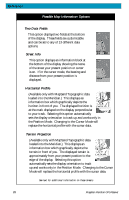
Two Data Fields, Street Info, Horizontal Profile, Terrain Projection
 |
UPC - 763357103267
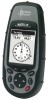
View all Magellan Meridian Platinum manuals
Add to My Manuals
Save this manual to your list of manuals |
Page 39 highlights
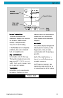
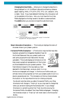
Reference Possible Map Information Options Two Data Fields This option displays two fields at the bottom of the display. These fields are customizable and can be set to any of 13 different data options. Street Info This option displays an information block at the bottom of the display showing the name of the street your present position or cursor is on. If in the cursor mode, the bearing and distance from your present position is displayed. Horizontal Profile (Available only with MapSend Topographic data loaded into the Meridian.) This displays an information box which graphically depicts the horizon in front of you. The displayed horizion is at the mark displayed on the display perpendicular to your track. Selecting this option automatically sets the display orientation to track up and works only in the Position Mode. Changing to the Cursor Mode will replace the horizontal profile with the cursor data. Terrain Projection (Available only with MapSend Topographic data loaded into the Meridian.) This displays an information box which graphically depicts the terrain in front of you. The displayed terrain is approximately from your present position to the edge of the display. Selecting this option automatically sets the display orientation to track up and works only in the Position Mode. Changing to the Cursor Mode will replace the horizontal profile with the cursor data. See text for additional information on these screens. 28 Magellan Meridian GPS Receiver
-
 1
1 -
2
-
3
-
4
-
5
-
6
-
7
-
8
-
9
-
10
-
11
-
12
-
13
-
14
-
15
-
16
-
17
-
18
-
19
-
20
-
21
-
22
-
23
-
24
-
25
-
26
-
27
-
28
-
29
-
30
-
31
-
32
-
33
-
 34
34 -
 35
35 -
 36
36 -
 37
37 -
 38
38 -
 39
39 -
 40
40 -
 41
41 -
 42
42 -
 43
43 -
 44
44 -
45
-
46
-
47
-
48
-
49
-
50
-
51
-
52
-
53
-
54
-
55
-
56
-
57
-
58
-
59
-
60
-
61
-
62
-
63
-
64
-
65
-
66
-
67
-
68
-
69
-
70
-
71
-
72
-
73
-
74
-
75
-
76
-
77
-
78
-
79
-
80
-
81
-
82
-
83
-
84
-
85
-
86
-
87
-
88
-
89
-
90
-
91
-
92
-
93
-
94
-
95
-
96
-
97
-
98
-
99
-
100
-
101
-
102
-
103
-
104
-
105
 |
 |
