Magellan Meridian Platinum User Manual - Page 7
Reference - maps
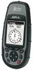 |
UPC - 763357103267
View all Magellan Meridian Platinum manuals
Add to My Manuals
Save this manual to your list of manuals |
Page 7 highlights
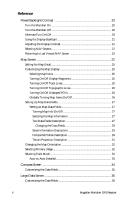
Reference Power/Backlight/Contrast 20 Turn the Meridian On 20 Turn the Meridian Off 20 Alternate Turn On/Off 20 Using the Display Backlight 21 Adjusting the Display Contrast 21 Selecting NAV Screens 22 Returning to Last Viewed NAV Screen 22 Map Screen 22 Setting the Map Detail 25 Customizing the Map Display 25 Selecting Map Items 25 Turning On/Off Display Waypoints 25 Turning On/Off Track Lines 25 Turning On/Off Topographic Lines 26 Turning On/Off Displayed POI's 26 Globally Turning Map Items On/Off 26 Setting Up Map Data Fields 27 Setting up Map Data Fields 27 Turning Map Info On/Off 27 Selecting the Map Information 27 Two Data Fields Description 27 Changing the Data Fields 29 Street Information Description 29 Horizontal Profile Description 29 Terrain Projection Description 31 Changing the Map Orientation 32 Selecting Primary Usage 32 Selecting Track Mode 32 Auto vs. Auto Detailed 33 Compass Screen 34 Customizing the Data Fields 35 Large Data Screen 35 Customizing the Data Fields 36 ii Magellan Meridian GPS Receiver
-
 1
1 -
 2
2 -
 3
3 -
 4
4 -
 5
5 -
 6
6 -
 7
7 -
 8
8 -
 9
9 -
 10
10 -
 11
11 -
 12
12 -
13
-
14
-
15
-
16
-
17
-
18
-
19
-
20
-
21
-
22
-
23
-
24
-
25
-
26
-
27
-
28
-
29
-
30
-
31
-
32
-
33
-
34
-
35
-
36
-
37
-
38
-
39
-
40
-
41
-
42
-
43
-
44
-
45
-
46
-
47
-
48
-
49
-
50
-
51
-
52
-
53
-
54
-
55
-
56
-
57
-
58
-
59
-
60
-
61
-
62
-
63
-
64
-
65
-
66
-
67
-
68
-
69
-
70
-
71
-
72
-
73
-
74
-
75
-
76
-
77
-
78
-
79
-
80
-
81
-
82
-
83
-
84
-
85
-
86
-
87
-
88
-
89
-
90
-
91
-
92
-
93
-
94
-
95
-
96
-
97
-
98
-
99
-
100
-
101
-
102
-
103
-
104
-
105
 |
 |
