Garmin GPSMAP 298C Owner's Manual - Page 36
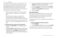
Map Options, To change data field contents and configuration
 |
UPC - 753759052072
View all Garmin GPSMAP 298C manuals
Add to My Manuals
Save this manual to your list of manuals |
Page 36 highlights
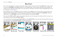
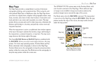
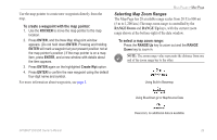
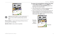
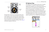
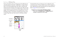
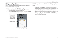
MAIN PAGES > MAP PAGE The GPSMAP 292/298 has a built-in worldwide database, with more detailed coverage available through the use of the optional preloaded BlueChart g2 data cards or other MapSource data. The GPSMAP 292/298 shows cartography as long as there is chart information available for the range you have selected. Map coverage conforms to the following conditions: • When the selected zoom range is covered by the internal database, BlueChart, or MapSource data, cartography is shown. • When the selected zoom range is covered by both the internal database and BlueChart/MapSource data, cartography is shown using the data with the best resolution. • When the selected zoom range exceeds the resolution of the data in use, an Overzoom warning appears below the zoom range. To change data field contents and configuration: 1. Press and hold DATA/CNFG. The Configuration window appears. 2. Using the ROCKER, highlight the function you want to add or remove, such as the status bar or first and second rows of data fields, and press ENTER. Only functions with a check mark in the check box to the left of the name appear on the main page. 3. Move the field highlight to the data field slider and use the ROCKER to select the number of data fields. 4. Move the field highlight to a data field, and press ENTER. 5. Using the ROCKER to move up or down on the list of data field options. Press ENTER to select an option. 6. To exit, press QUIT. Map Page Options Many features of the GPSMAP 292/298 are menu driven. Each main page has an options menu, allowing you to customize the corresponding page to your preferences and/or select special features that specifically relate to that page. The Map Page provides access to functions and features relating to the Map Page. To show and select the Map Page options: 1. Press ADJ/MENU. 2. Use the ROCKER to highlight an option, and press ENTER. The available options are Measure Distance, Show/Hide Detail, and Setup. Following are details on using each of these options. 30 GPSMAP 292/298 Owner's Manual
-
 1
1 -
2
-
3
-
4
-
5
-
6
-
7
-
8
-
9
-
10
-
11
-
12
-
13
-
14
-
15
-
16
-
17
-
18
-
19
-
20
-
21
-
22
-
23
-
24
-
25
-
26
-
27
-
28
-
29
-
30
-
 31
31 -
 32
32 -
 33
33 -
 34
34 -
 35
35 -
 36
36 -
 37
37 -
 38
38 -
 39
39 -
 40
40 -
 41
41 -
42
-
43
-
44
-
45
-
46
-
47
-
48
-
49
-
50
-
51
-
52
-
53
-
54
-
55
-
56
-
57
-
58
-
59
-
60
-
61
-
62
-
63
-
64
-
65
-
66
-
67
-
68
-
69
-
70
-
71
-
72
-
73
-
74
-
75
-
76
-
77
-
78
-
79
-
80
-
81
-
82
-
83
-
84
-
85
-
86
-
87
-
88
-
89
-
90
-
91
-
92
-
93
-
94
-
95
-
96
-
97
-
98
-
99
-
100
-
101
-
102
-
103
-
104
-
105
-
106
-
107
-
108
-
109
-
110
-
111
-
112
-
113
-
114
-
115
-
116
-
117
-
118
-
119
-
120
 |
 |