Garmin GPSMAP 298C Owner's Manual - Page 73
Distance, Speed and Elevation, Heading, Auto Mag Var, User Mag Var
 |
UPC - 753759052072
View all Garmin GPSMAP 298C manuals
Add to My Manuals
Save this manual to your list of manuals |
Page 73 highlights
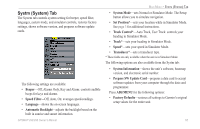
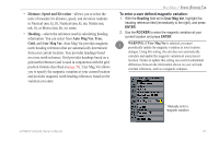
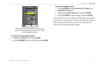
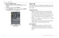
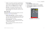
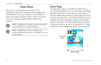
• Distance, Speed and Elevation-allows you to select the units of measure for distance, speed, and elevation readouts in Nautical (nm, kt, ft), Nautical (nm, kt, m), Statute (mi, mh, ft), or Metric (km, kh, m) terms. • Heading-selects the reference used in calculating heading information. You can select from Auto Mag Var, True, Grid, and User Mag Var. Auto Mag Var provides magnetic north heading references that are automatically determined from your current location. True provides headings based on a true north reference. Grid provides headings based on a grid north reference (and is used in conjunction with the grid position formats described on page 70). User Mag Var allows you to specify the magnetic variation at your current location and provides magnetic north heading references based on the variation you enter. MAIN MENU > SYSTM (SYSTEM) TAB To enter a user defined magnetic variation: 1. With the Heading field set to User Mag Var, highlight the heading reference field (immediately to the right), and press ENTER. 2. Use the ROCKER to enter the magnetic variation at your current location and press ENTER. WARNING: If User Mag Var is selected, you must periodically update the magnetic variation as your location changes. Using this setting, the unit does not automatically calculate and update the magnetic variation at your present location. Failure to update this setting can result in substantial differences between the information shown on your unit and external references, such as a magnetic compass. GPSMAP 292/298 Owner's Manual Manually enter a magnetic variation. 67
-
 1
1 -
2
-
3
-
4
-
5
-
6
-
7
-
8
-
9
-
10
-
11
-
12
-
13
-
14
-
15
-
16
-
17
-
18
-
19
-
20
-
21
-
22
-
23
-
24
-
25
-
26
-
27
-
28
-
29
-
30
-
31
-
32
-
33
-
34
-
35
-
36
-
37
-
38
-
39
-
40
-
41
-
42
-
43
-
44
-
45
-
46
-
47
-
48
-
49
-
50
-
51
-
52
-
53
-
54
-
55
-
56
-
57
-
58
-
59
-
60
-
61
-
62
-
63
-
64
-
65
-
66
-
67
-
 68
68 -
 69
69 -
 70
70 -
 71
71 -
 72
72 -
 73
73 -
 74
74 -
 75
75 -
 76
76 -
 77
77 -
 78
78 -
79
-
80
-
81
-
82
-
83
-
84
-
85
-
86
-
87
-
88
-
89
-
90
-
91
-
92
-
93
-
94
-
95
-
96
-
97
-
98
-
99
-
100
-
101
-
102
-
103
-
104
-
105
-
106
-
107
-
108
-
109
-
110
-
111
-
112
-
113
-
114
-
115
-
116
-
117
-
118
-
119
-
120
 |
 |
