Garmin GPSMAP 298C Owner's Manual - Page 88
Understanding the Sonar Screen, Transducer Coverage, circle at a 30-foot depth.
 |
UPC - 753759052072
View all Garmin GPSMAP 298C manuals
Add to My Manuals
Save this manual to your list of manuals |
Page 88 highlights
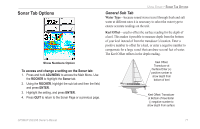
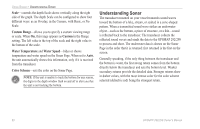
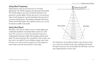
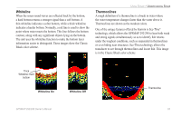
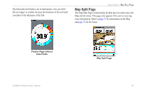
USING SONAR > UNDERSTANDING SONAR Understanding the Sonar Screen The Sonar Page does not show a three-dimensional representation of the underwater environment; the screen is in two-dimensions, much like if you took a picture of an aquarium. Only the depth of the item in the water is shown. The Sonar screen does not show you where an item is located horizontally in the water, as shown in the drawings below. The fish is not directly above the tree in reality, but it can look like it is on the Sonar Page. Transducer Coverage The area covered by the transmitted sound waves is determined by the cone angle of the transducer and the water depth. The wide cone angles (40°) associated with low frequencies (50 kHz) provide a large coverage area for finding fish within a coverage width that is approximately 2/3 of the water depth. However, this also means that wide cone angles produce less bottom detail and resolution. As shown in the drawing on the near right, the 40° cone angle produces a coverage area of approximately a 20-foot diameter circle at a 30-foot depth. The narrow cone angles (10°) associated with the high frequencies (200 kHz) provide better bottom resolution and crisper detail, but cannot show a large coverage area for finding fish. The 10° cone angle provides a coverage width that is approximately 2/10 of the water depth. As shown in the drawing on the far right, the 10° cone angle produces a coverage area of approximately a 6-foot diameter circle at a 30-foot depth. Dual frequency mode combines both frequencies to get the best coverage area and contour/depth readings. 82 GPSMAP 292/298 Owner's Manual
-
 1
1 -
2
-
3
-
4
-
5
-
6
-
7
-
8
-
9
-
10
-
11
-
12
-
13
-
14
-
15
-
16
-
17
-
18
-
19
-
20
-
21
-
22
-
23
-
24
-
25
-
26
-
27
-
28
-
29
-
30
-
31
-
32
-
33
-
34
-
35
-
36
-
37
-
38
-
39
-
40
-
41
-
42
-
43
-
44
-
45
-
46
-
47
-
48
-
49
-
50
-
51
-
52
-
53
-
54
-
55
-
56
-
57
-
58
-
59
-
60
-
61
-
62
-
63
-
64
-
65
-
66
-
67
-
68
-
69
-
70
-
71
-
72
-
73
-
74
-
75
-
76
-
77
-
78
-
79
-
80
-
81
-
82
-
 83
83 -
 84
84 -
 85
85 -
 86
86 -
 87
87 -
 88
88 -
 89
89 -
 90
90 -
 91
91 -
 92
92 -
 93
93 -
94
-
95
-
96
-
97
-
98
-
99
-
100
-
101
-
102
-
103
-
104
-
105
-
106
-
107
-
108
-
109
-
110
-
111
-
112
-
113
-
114
-
115
-
116
-
117
-
118
-
119
-
120
 |
 |