Garmin GPSMAP 298C Owner's Manual - Page 68
Detail Sub Tab, and Lat/Lon Grid
 |
UPC - 753759052072
View all Garmin GPSMAP 298C manuals
Add to My Manuals
Save this manual to your list of manuals |
Page 68 highlights
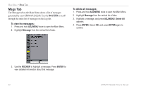
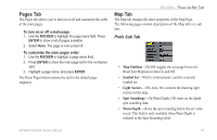
MAIN MENU > MAP TAB • Orientation-North Up: fixes the top of the Map Page to a north heading. Track Up: fixes the top of the Map Page to the current track heading. Course Up: fixes the map so the direction of navigation is always up. Detail Sub Tab • Chart-Most, More, Normal, Less, Least: controls how much map detail is shown. This setting only applies to map features set to Auto. Features that have a specified zoom range or are turned off are unaffected by this setting. • Waypoints, Active Route, Tide Stations, Services, Saved Tracks, Track Log, and Lat/Lon Grid-Auto, Off, 120 ft-800 mi: sets the maximum zoom range the feature should appear on the Map Page. Some types of data only show up to specific zoom ranges. Labels Sub Tab The Labels Sub Tab contains the screen size of the name or symbol of the listed feature. You can choose from None, Small, Medium, and Large. Nav Sub Tab • AutoZoom-On, Off: when On the map automatically adjusts the map zoom range to a lower range as you approach you destination point. • Accuracy Circle-On, Off: toggles the circle On and Off. The circle represents the approximate accuracy of the unit based on EPE, DOP, and basemap quality. Your location is within the circle. • Bearing Line-On, Off: toggles the black/white line that points to the current navigation point. • Course Line-Auto, Off, 120 ft-800 mi: sets the maximum zoom range the course line appears on the screen. • Heading Line-On, Off: draws an extension from the end of the boat icon in the direction of travel. AIS Sub Tab Refer to page 25 for more information on AIS. 62 GPSMAP 292/298 Owner's Manual
-
 1
1 -
2
-
3
-
4
-
5
-
6
-
7
-
8
-
9
-
10
-
11
-
12
-
13
-
14
-
15
-
16
-
17
-
18
-
19
-
20
-
21
-
22
-
23
-
24
-
25
-
26
-
27
-
28
-
29
-
30
-
31
-
32
-
33
-
34
-
35
-
36
-
37
-
38
-
39
-
40
-
41
-
42
-
43
-
44
-
45
-
46
-
47
-
48
-
49
-
50
-
51
-
52
-
53
-
54
-
55
-
56
-
57
-
58
-
59
-
60
-
61
-
62
-
 63
63 -
 64
64 -
 65
65 -
 66
66 -
 67
67 -
 68
68 -
 69
69 -
 70
70 -
 71
71 -
 72
72 -
 73
73 -
74
-
75
-
76
-
77
-
78
-
79
-
80
-
81
-
82
-
83
-
84
-
85
-
86
-
87
-
88
-
89
-
90
-
91
-
92
-
93
-
94
-
95
-
96
-
97
-
98
-
99
-
100
-
101
-
102
-
103
-
104
-
105
-
106
-
107
-
108
-
109
-
110
-
111
-
112
-
113
-
114
-
115
-
116
-
117
-
118
-
119
-
120
 |
 |
