Garmin GPSMAP 298C Owner's Manual - Page 90
Flasher soft bottom, hard bottom
 |
UPC - 753759052072
View all Garmin GPSMAP 298C manuals
Add to My Manuals
Save this manual to your list of manuals |
Page 90 highlights
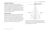
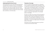
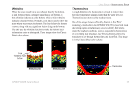
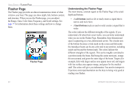
USING SONAR > FLASHER PAGE Flasher Page The Flasher page provides an almost instantaneous return of what is below your boat. This page can show depth, fish, bottom content, and structure. When you use the Flasher page, you can adjust the Range, Gain, Color Gain, Frequency, and Scroll settings. See page 77 for information about these settings and how to change them. Flasher Page Understanding the Flasher Page The most intense, constant signal on the Flasher Page is the actual depth and bottom: • A soft bottom (such as silt or mud) creates a signal that is narrow and more faint. • A hard bottom (such as sand or rock) creates a signal that is wider. The colors indicate the different strengths of the signals. If you understand a bit about how sonar works, you can better understand what you see on the Flasher Page. Remember, three-dimensional space is appearing on a two-dimensional screen. The circular area of the bottom becomes a wide mark on the screen and fish inside the transducer beam can be any color and in any position, including inside and beyond the bottom mark. The colors indicate the different strengths of the signals. This can be roughly correlated to a position inside the beam. Red being the center most part, orange the area around, and green the outer edge of the beam. Targets (for example, fish) with larger surface area appear more red; and targets with less surface area appear orange, and green for the smallest stuff. The colors will give you information. You need to interpret it. Experience and experimentation are the keys to being very good at reading your flasher. 84 GPSMAP 292/298 Owner's Manual
-
 1
1 -
2
-
3
-
4
-
5
-
6
-
7
-
8
-
9
-
10
-
11
-
12
-
13
-
14
-
15
-
16
-
17
-
18
-
19
-
20
-
21
-
22
-
23
-
24
-
25
-
26
-
27
-
28
-
29
-
30
-
31
-
32
-
33
-
34
-
35
-
36
-
37
-
38
-
39
-
40
-
41
-
42
-
43
-
44
-
45
-
46
-
47
-
48
-
49
-
50
-
51
-
52
-
53
-
54
-
55
-
56
-
57
-
58
-
59
-
60
-
61
-
62
-
63
-
64
-
65
-
66
-
67
-
68
-
69
-
70
-
71
-
72
-
73
-
74
-
75
-
76
-
77
-
78
-
79
-
80
-
81
-
82
-
83
-
84
-
 85
85 -
 86
86 -
 87
87 -
 88
88 -
 89
89 -
 90
90 -
 91
91 -
 92
92 -
 93
93 -
 94
94 -
 95
95 -
96
-
97
-
98
-
99
-
100
-
101
-
102
-
103
-
104
-
105
-
106
-
107
-
108
-
109
-
110
-
111
-
112
-
113
-
114
-
115
-
116
-
117
-
118
-
119
-
120
 |
 |